< STS043-151-163 >
| NASA Photo ID | STS043-151-163 |
| Focal Length | 90mm |
| Date taken | 1991.08.09 |
| Time taken | 18:19:22 GMT |
Resolutions offered for this image:
640 x 480 pixels
640 x 480 pixels
Cloud masks available for this image:
Spacecraft nadir point: 15.2° S, 67.3° W
Photo center point: 15.5° S, 70.0° W
Photo center point by machine learning:
Photo center point: 15.5° S, 70.0° W
Photo center point by machine learning:
Nadir to Photo Center: West
Spacecraft Altitude: 165 nautical miles (306km)
Country or Geographic Name: | PERU |
Features: | PAN, ANDES MOUNTAINS |
| Features Found Using Machine Learning: | |
Cloud Cover Percentage: | 60 (51-75)% |
Sun Elevation Angle: | 49° |
Sun Azimuth: | 319° |
Camera: | Linhof |
Focal Length: | 90mm |
Camera Tilt: | High Oblique |
Format: | QX868: Kodak, natural color positive, Ektachrome QX868(5017 emulsion), ASA 64, thin base |
Film Exposure: | Normal |
| Additional Information | |
| Width | Height | Annotated | Cropped | Purpose | Links |
|---|---|---|---|---|---|
| 640 pixels | 480 pixels | No | No | ISD 1 | Download Image |
Download Packaged File
Download a Google Earth KML for this Image
View photo footprint information
No GeoTIFF is available for this photo.Image Caption:
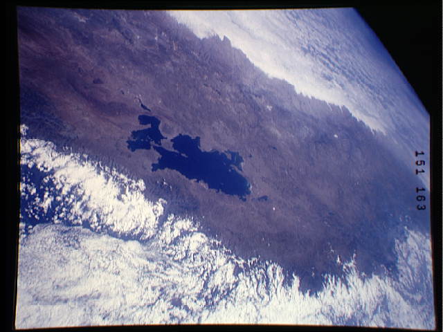
S43-151-163 - Lake Titicaca
The lake is seen in this oblique northwestward view. The lake, at
an altitude of 3800 meters, and having a depth of 300 meters, is
the highest navigable lake on Earth. The capital of Bolivia, La
Paz, may be seen at the center left. Linhof camera, 90mm lens, 8
August 1991, 18:19 GMT
Lake Titicaca, high in the Andean Altiplano of South America, is on the border between Peru and Bolivia (15.5S, 70.0W). At an altitude of 12,500 ft, an area of 3,206 sq. mi. and a depth of about 900 ft., it is the world's highest navigable fresh water lake. La Paz, the capital city of Bolivia, may be seen near the center left of the image on the eastern downslope side of the mountains. 3,206 sq mi (8,303 sqkm), 12,
