< STS41C-36-1618 >
| NASA Photo ID | STS41C-36-1618 |
| Focal Length | 50mm |
| Date taken | 1984.04.__ |
| Time taken | GMT |


Cloud masks available for this image:
Spacecraft nadir point:
Photo center point: 27.0° N, 85.0° W
Photo center point by machine learning:
Photo center point: 27.0° N, 85.0° W
Photo center point by machine learning:
Nadir to Photo Center:
Spacecraft Altitude: nautical miles (0km)
Country or Geographic Name: | GULF OF MEXICO |
Features: | LDEF DEPLOY-RMS |
| Features Found Using Machine Learning: | |
Cloud Cover Percentage: | 60 (51-75)% |
Sun Elevation Angle: | ° |
Sun Azimuth: | ° |
Camera: | Hasselblad |
Focal Length: | 50mm |
Camera Tilt: | High Oblique |
Format: | 6017: Kodak Ektachrome 64, 220 Roll Format |
Film Exposure: | Normal |
| Additional Information | |
| Width | Height | Annotated | Cropped | Purpose | Links |
|---|---|---|---|---|---|
| 4410 pixels | 4600 pixels | No | No | Download Image | |
| 479 pixels | 500 pixels | No | No | Download Image | |
| 640 pixels | 480 pixels | No | No | Download Image |
Download Packaged File
Download a Google Earth KML for this Image
View photo footprint information
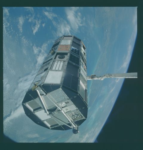
No GeoTIFF is available for this photo.Image Caption: This single scene, taken during the Long Duration Exposure Facility (LDEF) satellite deploy, captures the entire Florida Peninsula (27.0N, 85.0W) in a single view. The multi-paneled LDEF satellite, suspended by the RMS, is undergoing final checkout procedures immediately prior to release. As a long term materials testing facility, the LDEF contained material samples in the many surface panels to determine the effects of long term exposure to space. multi-paneled LDEF satellite was deployed 27.0N, 85.0W)
