< STS043-151-159 >
| NASA Photo ID | STS043-151-159 |
| Focal Length | 90mm |
| Date taken | 1991.08.09 |
| Time taken | 18:18:15 GMT |
Resolutions offered for this image:
640 x 480 pixels
640 x 480 pixels
Cloud masks available for this image:
Spacecraft nadir point: 13.3° S, 71.2° W
Photo center point: 14.5° S, 72.5° W
Photo center point by machine learning:
Photo center point: 14.5° S, 72.5° W
Photo center point by machine learning:
Nadir to Photo Center: Southwest
Spacecraft Altitude: 166 nautical miles (307km)
Country or Geographic Name: | PERU |
Features: | PAN, ANDES MTNS. |
| Features Found Using Machine Learning: | |
Cloud Cover Percentage: | 40 (26-50)% |
Sun Elevation Angle: | 53° |
Sun Azimuth: | 322° |
Camera: | Linhof |
Focal Length: | 90mm |
Camera Tilt: | High Oblique |
Format: | QX868: Kodak, natural color positive, Ektachrome QX868(5017 emulsion), ASA 64, thin base |
Film Exposure: | Normal |
| Additional Information | |
| Width | Height | Annotated | Cropped | Purpose | Links |
|---|---|---|---|---|---|
| 640 pixels | 480 pixels | No | No | ISD 1 | Download Image |
Download Packaged File
Download a Google Earth KML for this Image
View photo footprint information
No GeoTIFF is available for this photo.Image Caption:
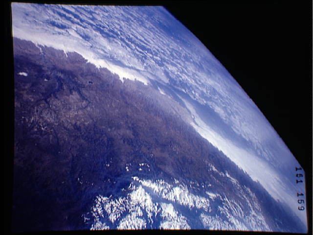
S43-151-159 - South American Coast
This photograph looks westward over the high plateau of the
southern Peruvian Andes west and north of Lake Titicaca (not in
field of view). Lima, Peru lies under the clouds just north of
the clear coastal area. Because the high Andes have been uplifted
10,000 to 13,000 feet during the past 20 million years, the
rivers which cut down to the Pacific Ocean have gorges almost
that deep, such as the Rio Ocona at the bottom of the photograph.
The eastern slopes of the Andes are heavily forested, forming the
headwaaters of the Amazon system. Smoke from burning in the Ama-
zon basin fills river valleys on the right side of the photo-
graph. Linhof camera, 90mm lens, GMT
