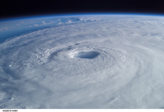
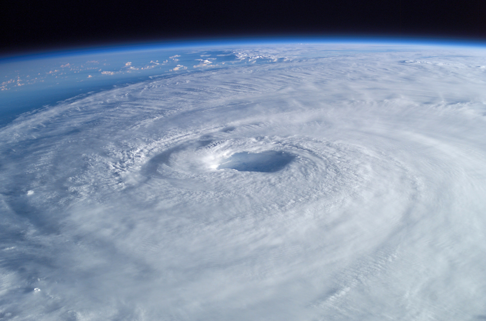
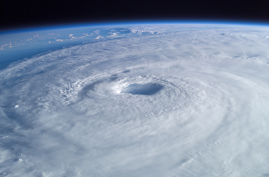
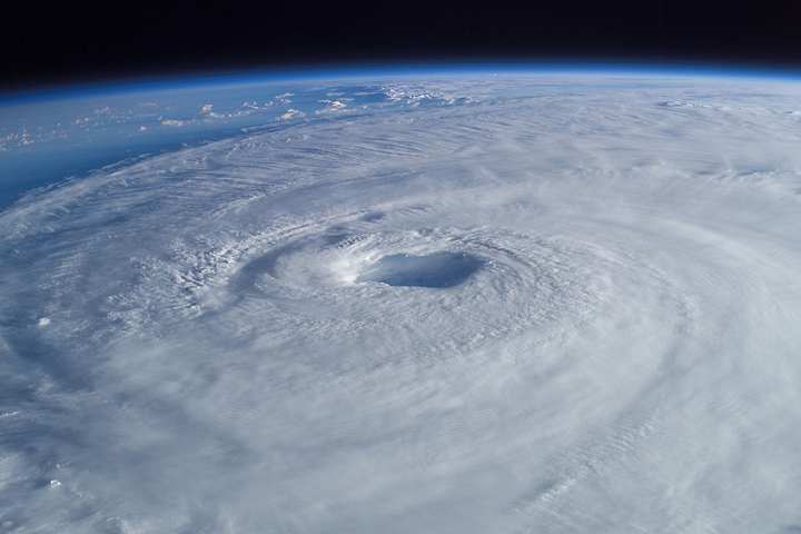
ISS007-E-14887
| NASA Photo ID | ISS007-E-14887 |
| Focal Length | 50mm |
| Date taken | 2003.09.15 |
| Time taken | 10:54:05 GMT |
Resolutions offered for this image:
1000 x 660 pixels 540 x 356 pixels 720 x 480 pixels 1024 x 768 pixels 540 x 405 pixels 3032 x 2064 pixels 639 x 435 pixels
1000 x 660 pixels 540 x 356 pixels 720 x 480 pixels 1024 x 768 pixels 540 x 405 pixels 3032 x 2064 pixels 639 x 435 pixels


Spacecraft nadir point: 17.6° N, 66.4° W
Photo center point: 25.0° N, 69.0° W
Photo center point by machine learning:
Photo center point: 25.0° N, 69.0° W
Photo center point by machine learning:
Nadir to Photo Center: North
Spacecraft Altitude: 204 nautical miles (378km)
Country or Geographic Name: | ATLANTIC OCEAN |
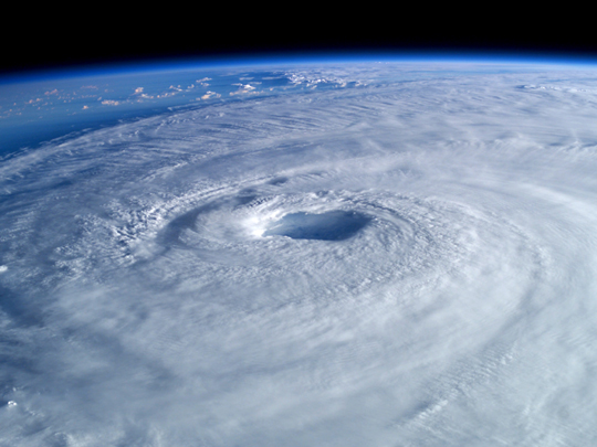
Features: | PAN-HURRICANE ISABEL, EYE |
| Features Found Using Machine Learning: | PAN- |
Cloud Cover Percentage: | 100 (76-100)% |
Sun Elevation Angle: | 9° |
Sun Azimuth: | 90° |
Camera: | Kodak DCS760c Electronic Still Camera |
Focal Length: | 50mm |
Camera Tilt: | High Oblique |
Format: | 3060E: 3060 x 2036 pixel CCD, RGBG array |
Film Exposure: | |
| Additional Information | |
| Width | Height | Annotated | Cropped | Purpose | Links |
|---|---|---|---|---|---|
| 1000 pixels | 660 pixels | No | Yes | Earth From Space collection | Download Image |
| 540 pixels | 356 pixels | No | Yes | Earth From Space collection | Download Image |
| 720 pixels | 480 pixels | No | No | NASA's Earth Observatory web site | Download Image |
| 1024 pixels | 768 pixels | Yes | Yes | Presentation | Download Image |
| 540 pixels | 405 pixels | Yes | Yes | Presentation | Download Image |
| 3032 pixels | 2064 pixels | No | No | Download Image | |
| 639 pixels | 435 pixels | No | No | Download Image |
Download Packaged File
Download a Google Earth KML for this Image
View photo footprint information
Download a GeoTIFF for this photo
Image Caption: Astronaut Ed Lu snapped this oblique photo of Hurricane Isabel from the International Space Station on September 15, 2003 at 10:54 UTC. At the time, Isabel was heading for the east coast of the US . It had dropped to a Category 3 hurricane on the Saffir-Simpson Hurricane Scale. After originating in the eastern Atlantic west of the Cape Verde Islands, Isabel became the second major hurricane of the 2003 Atlantic season when it was declared a Category 3 storm by the National Hurricane Center on September 8. Over the next four days, Isabel strengthened into an extremely powerful Category 5 hurricane with winds estimated at 160 mph before dropping in strength as it approached the US.
Why Unique: These images taken obliquely provide both detail and vertical structure of the storm. Images like these have been used by researchers to characterize the bands of thunderstorms around the eye, and understand the short term dynamics of the storm.
These images were used by the National Hurricane Center, NOAA, the Weather channel and many other media organizations covering the news story.
