< ISS024-E-12749 >

| NASA Photo ID | ISS024-E-12749 |
| Focal Length | 180mm |
| Date taken | 2010.08.28 |
| Time taken | 12:41:09 GMT |
Resolutions offered for this image:
1000 x 698 pixels 540 x 377 pixels 720 x 480 pixels 4288 x 2929 pixels 640 x 437 pixels
1000 x 698 pixels 540 x 377 pixels 720 x 480 pixels 4288 x 2929 pixels 640 x 437 pixels


Spacecraft nadir point: 28.8° S, 27.9° E
Photo center point: 29.3° S, 27.5° E
Photo center point by machine learning: 29.32° S, 27.49° E
Photo center point: 29.3° S, 27.5° E
Photo center point by machine learning: 29.32° S, 27.49° E
Nadir to Photo Center: Southwest
Spacecraft Altitude: 191 nautical miles (354km)

Country or Geographic Name: | LESOTHO |
Features: | MASERU, LADYBRAND, CALEDON RIVER, AGR., DISSECTED PLATEAU |
| Features Found Using Machine Learning: | |
Cloud Cover Percentage: | 10 (1-10)% |
Sun Elevation Angle: | 37° |
Sun Azimuth: | 311° |
Camera: | Nikon D2Xs Electronic Still Camera |
Focal Length: | 180mm |
Camera Tilt: | 11 degrees |
Format: | 4288E: 4288 x 2848 pixel CMOS sensor, RGBG imager color filter |
Film Exposure: | |
| Additional Information | |
| Width | Height | Annotated | Cropped | Purpose | Links |
|---|---|---|---|---|---|
| 1000 pixels | 698 pixels | No | Yes | Earth From Space collection | Download Image |
| 540 pixels | 377 pixels | Yes | Yes | Earth From Space collection | Download Image |
| 720 pixels | 480 pixels | Yes | Yes | NASA's Earth Observatory web site | Download Image |
| 4288 pixels | 2929 pixels | No | No | Download Image | |
| 640 pixels | 437 pixels | No | No | Download Image |
Download Packaged File
Download a Google Earth KML for this Image
View photo footprint information
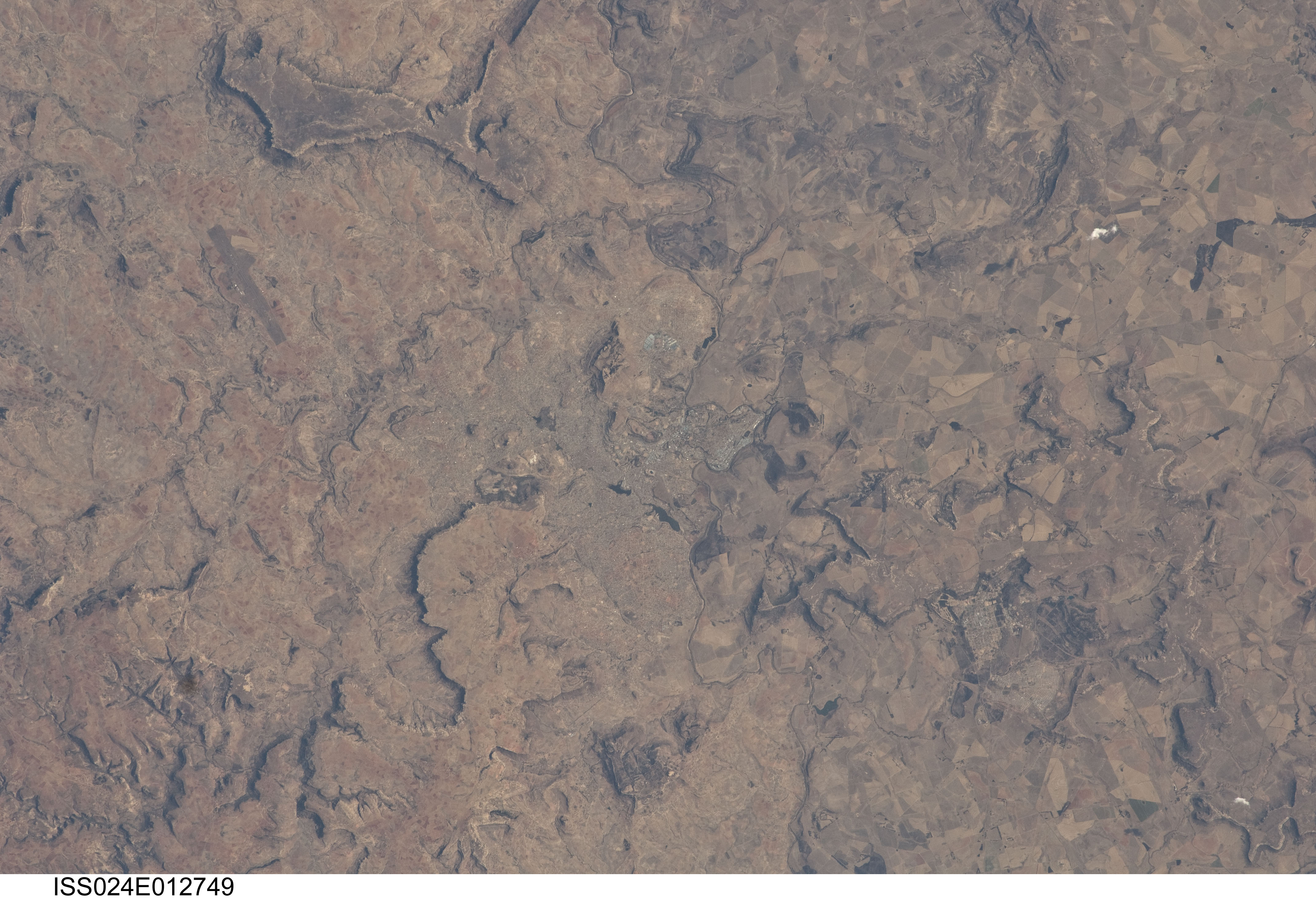
No GeoTIFF is available for this photo.Image Caption: Maseru, Lesotho
Maseru is the capital city of the Kingdom of Lesotho, and is located along the northwestern border of the country with the Republic of South Africa. The footprint of the urban area, recognizable by street grids and distinctive blue-roofed industrial buildings at image center, is only just visible against the surrounding landscape. The city has expanded eightfold (population 230,000 today) since independence from the United Kingdom of Great Britain and Northern Ireland in 1966, and is now home to one in five citizens of the country.
The Caledon (or Mohokare) River flows adjacent to Maseru and forms a part of the border between Lesotho and South Africa. Locally, the border extends from approximately image top center left to image bottom center right, with the cities of Ladybrand and Manyatseng located in South Africa. Moshoeshoe International Airport (left) provides access to the capital. Major industries in the city include flour mills and footwear and textile companies. Tourism is also a growing part of the local economy.
The Kingdom of Lesotho is completely landlocked by the surrounding Republic of South Africa. Major landforms visible in the image include the Qeme and Berea Plateaus, erosional remnants of horizontally layered sedimentary rocks that formed in the Karoo Basin approximately 200 - 229 million years ago during the Upper Triassic Period.
