< STS030-151-122 >
| NASA Photo ID | STS030-151-122 |
| Focal Length | 250mm |
| Date taken | 1989.05.06 |
| Time taken | 14:24:00 GMT |
Resolutions offered for this image:
640 x 480 pixels
640 x 480 pixels
Cloud masks available for this image:
Spacecraft nadir point: 13.2° N, 87.8° W
Photo center point: 12.5° N, 87.0° W
Photo center point by machine learning:
Photo center point: 12.5° N, 87.0° W
Photo center point by machine learning:
Nadir to Photo Center: Southeast
Spacecraft Altitude: 177 nautical miles (328km)
Country or Geographic Name: | NICARAGUA |
Features: | GOLFO DE FONSECA |
| Features Found Using Machine Learning: | |
Cloud Cover Percentage: | 30 (26-50)% |
Sun Elevation Angle: | 40° |
Sun Azimuth: | 79° |
Camera: | Linhof |
Focal Length: | 250mm |
Camera Tilt: | 20 degrees |
Format: | 5017: Kodak, natural color positive, Ektachrome, X Professional, ASA 64, standard base |
Film Exposure: | Normal |
| Additional Information | |
| Width | Height | Annotated | Cropped | Purpose | Links |
|---|---|---|---|---|---|
| 640 pixels | 480 pixels | No | No | ISD 1 | Download Image |
Download Packaged File
Download a Google Earth KML for this Image
View photo footprint information
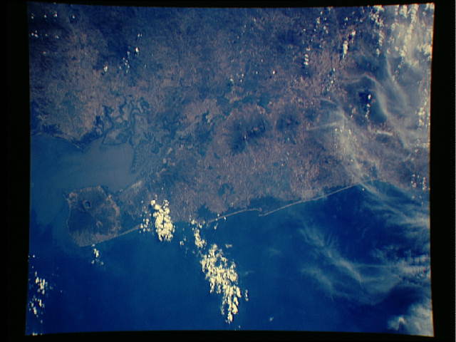
No GeoTIFF is available for this photo.Image Caption: This 150 kilometer stretch of the Pacific coastal plain of Nicaragua (12.0N, 86.5W) from the Gulf of Fonseca to Lake Managua. The large crater on the peninsula is Coseguina, which erupted in 1835, forming a 2 km. wide by 500 meter deep caldera and deposited ash as far away as Mexico City, some 1400 km. to the north. A plume of Steam can be seen venting from San Cristobal volcano, in the Marabios Range, the highest mouintain in Nicaragua.
