< ISS036-E-10628 >
| NASA Photo ID | ISS036-E-10628 |
| Focal Length | 400mm |
| Date taken | 2013.06.23 |
| Time taken | 10:22:13 GMT |
Resolutions offered for this image:
1000 x 665 pixels 540 x 359 pixels 1440 x 960 pixels 720 x 480 pixels 4256 x 2832 pixels 640 x 426 pixels
1000 x 665 pixels 540 x 359 pixels 1440 x 960 pixels 720 x 480 pixels 4256 x 2832 pixels 640 x 426 pixels


Spacecraft nadir point: 28.5° N, 35.3° E
Photo center point: 28.0° N, 34.5° E
Photo center point by machine learning: 27.96° N, 34.52° E
Photo center point: 28.0° N, 34.5° E
Photo center point by machine learning: 27.96° N, 34.52° E
Nadir to Photo Center: Southwest
Spacecraft Altitude: 220 nautical miles (407km)

Country or Geographic Name: | SAUDI ARABIA |
Features: | TIRAN ISLAND, NABQ, STRAITS OF TIRAN, RED SEA, GULF OF AQABA |
| Features Found Using Machine Learning: | |
Cloud Cover Percentage: | 10 (1-10)% |
Sun Elevation Angle: | 80° |
Sun Azimuth: | 245° |
Camera: | Nikon D3S Electronic Still Camera |
Focal Length: | 400mm |
Camera Tilt: | 14 degrees |
Format: | 4256E: 4256 x 2832 pixel CMOS sensor, 36.0mm x 23.9mm, total pixels: 12.87 million, Nikon FX format |
Film Exposure: | |
| Additional Information | |
| Width | Height | Annotated | Cropped | Purpose | Links |
|---|---|---|---|---|---|
| 1000 pixels | 665 pixels | No | Yes | Earth From Space collection | Download Image |
| 540 pixels | 359 pixels | Yes | Yes | Earth From Space collection | Download Image |
| 1440 pixels | 960 pixels | No | Yes | NASA's Earth Observatory web site | Download Image |
| 720 pixels | 480 pixels | Yes | No | NASA's Earth Observatory web site | Download Image |
| 4256 pixels | 2832 pixels | No | No | Download Image | |
| 640 pixels | 426 pixels | No | No | Download Image |
Download Packaged File
Download a Google Earth KML for this Image
View photo footprint information
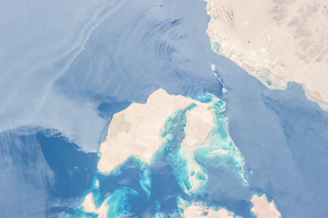
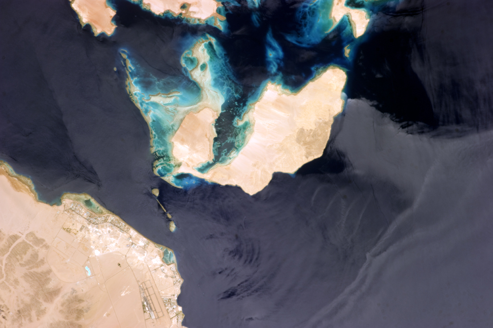
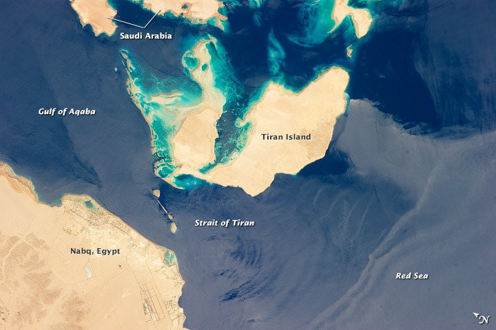
No GeoTIFF is available for this photo.Image Caption: Strait of Tiran, Red Sea and Gulf of Aqaba
Note: This caption refers to the image versions labeled "NASA's Earth Observatory web site".
The approximately 6 kilometer wide Strait of Tiran (also known as the Straits of Tiran) between the Egyptian mainland and Tiran Island separates the Gulf of Aqaba from the Red Sea, and provides two channels (290 m and 73 m deep, respectively) navigable by large ships bound for ports in Jordan and Israel. A smaller passage also exists between the east side of Tiran Island and Saudi Arabia, but this a single channel that is 16 meters deep. Due to its strategic position, control of the Strait has been an important factor in historical conflicts of the region, such as the Suez Crisis in 1956 and the Six-Day War in 1967.
This astronaut photograph from the International Space Station (ISS) illustrates the morphology of the Strait. The relatively clear, deep water passages of the western Strait of Tiran are visible at image left, while the more sinuous shallow-water passage on the Saudi Arabia side can be seen at image top center. Light blue to turquoise areas around Tiran Island indicate shallow water, while the island itself is arid and largely free of vegetation. Coral reefs are also found in the Straits of Tiran and are a popular diving destination.
The silvery sheen on the water surface within the Strait and the south of Tiran Island is sunglint - light reflecting off the water surface back towards the astronaut observer on the ISS . Disturbance to the water surface, as well as presence of substances such as oils and surfactants, can change the reflective properties of the water surface and highlight both surface waves and subsurface currents. For example, a large wave set is highlighted by sunglint at image lower right.
