< STS039-94-10 >

| NASA Photo ID | STS039-94-10 |
| Focal Length | 250mm |
| Date taken | 1991.05.04 |
| Time taken | 20:18:48 GMT |
Resolutions offered for this image:
3936 x 3872 pixels 639 x 629 pixels 5700 x 6000 pixels 500 x 526 pixels 640 x 480 pixels
3936 x 3872 pixels 639 x 629 pixels 5700 x 6000 pixels 500 x 526 pixels 640 x 480 pixels


Cloud masks available for this image:
Spacecraft nadir point: 36.2° N, 115.9° W
Photo center point: 32.7° N, 115.0° W
Photo center point by machine learning:
Photo center point: 32.7° N, 115.0° W
Photo center point by machine learning:
Nadir to Photo Center: South
Spacecraft Altitude: 145 nautical miles (269km)
Country or Geographic Name: | USA-CALIFORNIA |
Features: | US-MEXICO BORDER |
| Features Found Using Machine Learning: | |
Cloud Cover Percentage: | 0 (no clouds present) |
Sun Elevation Angle: | 59° |
Sun Azimuth: | 172° |
Camera: | Hasselblad |
Focal Length: | 250mm |
Camera Tilt: | Low Oblique |
Format: | 5017: Kodak, natural color positive, Ektachrome, X Professional, ASA 64, standard base |
Film Exposure: | Normal |
| Additional Information | |
| Width | Height | Annotated | Cropped | Purpose | Links |
|---|---|---|---|---|---|
| 3936 pixels | 3872 pixels | No | No | Earth From Space collection | Download Image |
| 639 pixels | 629 pixels | No | No | Earth From Space collection | Download Image |
| 5700 pixels | 6000 pixels | No | No | Download Image Download Color Calibration Image for this Image |
|
| 500 pixels | 526 pixels | No | No | Download Image Download Color Calibration Image for this Image |
|
| 640 pixels | 480 pixels | No | No | Download Image |
Download Packaged File
Download a Google Earth KML for this Image
View photo footprint information
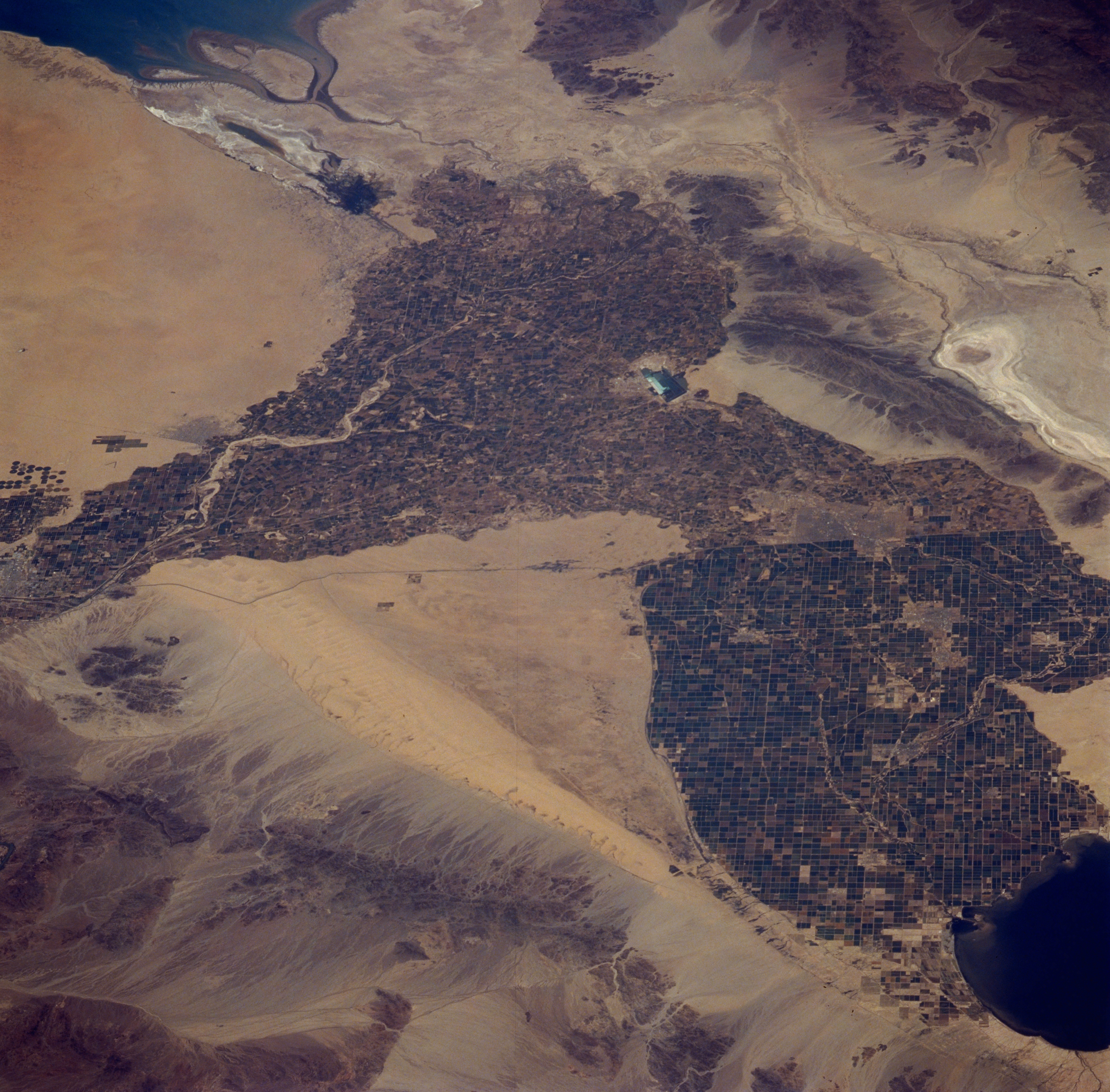
No GeoTIFF is available for this photo.Image Caption: STS039-094-010 Sonoran Desert, California, U.S.A. and Mexico May 1991
The light browns and tans of this photograph provide a clue to the natural environment for this part of southern California. This section of the Sonoran Desert shows two large, irrigated, cultivated field patterns where a variety of crops is grown--cotton, winter vegetables, alfalfa, citrus fruits, and dates. The Imperial Valley to the north contains large, regimented fields where mechanized, commercial agriculture is practiced (U.S. side of the border). The roughly triangular Colorado River delta shows smaller irrigated fields that are not neatly aligned (Mexican side of the border). The dark east-west line is the U.S.-Mexico border. A line of northwest-southeast-trending sand dunes, the Sand Hills, separates the Imperial Valley from the Chocolate Mountains to the east. The Salton Sea, 230 feet (70 meters) below sea level, is visible to the northwest. The highly reflective Laguna Salada, extending south of the border, intermittently receives water.
The light browns and tans of this photograph provide a clue to the natural environment for this part of southern California. This section of the Sonoran Desert shows two large, irrigated, cultivated field patterns where a variety of crops is grown--cotton, winter vegetables, alfalfa, citrus fruits, and dates. The Imperial Valley to the north contains large, regimented fields where mechanized, commercial agriculture is practiced (U.S. side of the border). The roughly triangular Colorado River delta shows smaller irrigated fields that are not neatly aligned (Mexican side of the border). The dark east-west line is the U.S.-Mexico border. A line of northwest-southeast-trending sand dunes, the Sand Hills, separates the Imperial Valley from the Chocolate Mountains to the east. The Salton Sea, 230 feet (70 meters) below sea level, is visible to the northwest. The highly reflective Laguna Salada, extending south of the border, intermittently receives water.
