DATA FUSION IN CORAL REEF MAPPING:
WORKING AT MULTIPLE SCALES WITH SeaWiFS AND ASTRONAUT PHOTOGRAPHY [*]
Julie A. Robinson
Office of Earth Sciences, Johnson Space Center
Houston, Texas, U. S. A.
Gene C. Feldman, Norman Kuring, and Bryan Franz
NASA Goddard Space Flight Center
Greenbelt, Maryland, U. S. A.
Ed Green
World Conservation Monitoring Centre
Cambridge, U. K.
Marco Noordeloos
International Center for Living Aquatic Resources Management
Penang, Malaysia
Richard P. Stumpf
NOAA National Ocean Service
Silver Spring, Maryland, U. S. A.
Recommended Citation: Robinson, J. A., G. C. Feldman, N. Kuring, B. Franz, E. Green, M. Noordeloos, and R. P. Stumpf. 2000. Data fusion in coral reef mapping: working at multiple scales with SeaWiFS and astronaut photography. Proceedings of the 6th International Conference on Remote Sensing for Marine and Coastal Environments, Vol. 2, pp. 473-483. Also available at http://eol.jsc.nasa.gov/newsletter/DataFusionInCoralReefMapping/
ABSTRACT
Limitations in knowledge on the location, extent, and status of coral reefs have led to international calls to improve the mapping of coral reef environments. Ideally, mapping programs will work simultaneously at multiple scales to produce maps quickly and then improve these maps over time. We describe an approach to reef mapping that uses a uniform 1-km dataset (SeaWiFS) as a backbone for global-scale reef mapping and for integrating other higher-resolution remote sensing data. SeaWiFS data were used to produce composite maps of bathymetry. Global reef maps compiled by the World Conservation Monitoring Centre can be overlaid with SeaWiFS data to facilitate comparison and refinement of the maps. Data sets at moderate resolution (e.g. Landsat) and high resolution (e.g. aerial photography) were converted to the same projection. Astronaut photography of Earth is an additional source of moderate resolution (pixel sizes of 30 m or less) remote sensing data that makes a unique contribution to these datasets. We describe the methods used to georeference astronaut photographs for incorporation into ReefBase and the WCMC-SeaWiFS database. Georeferenced astronaut photographs were incorporated as GIS base layers into a prototype for ReefBase: A Global Database on Coral Reefs, and linked to information on coral reef biology, status, exploitation, management and socioeconomics. Finally, the global maps and remote sensing data were made available for interactive searching on a prototype Coral Reef Remote Sensing Web site (http://oceancolor.gsfc.nasa.gov/SeaWiFS/reefs/).
1.0 INTRODUCTION
The high biological diversity of coral reefs make them valuable resources that sustain local and national economies through fisheries, coastal protection, and tourism. In spite of these important benefits, it has been estimated that 58% of coral reefs globally are threatened by human activities (Bryant et al., 1998; Hoegh-Guldberg, 1999). Lack of scientific data about the locations, spatial extent, and health of reefs have hindered responses to these threats. There have been a number of international calls from non-governmental organizations and groups of scientists to improve the mapping of coral reef environments (e.g., McManus and Noordeloos, 1998; Center for Marine Conservation, 1999; Cousteau Society, 1999; USDOC/NOAA/NESDIS et al., 1999) and mapping has been one of the major working themes for the U.S. Coral Reef Taskforce (1999).
Estimates of near-surface reef area vary from 255,000 km2 (Spalding and Grenfell, 1997) to 600,000 km2 (Smith, 1978) and even as high as 1,432,000 km2 (Kleypas, 1997). These figures both define the lack of information about existing reefs, and the spatial extent of the challenge for increasing available information. Remote sensing provides the only feasible means for global inventory and monitoring of reefs. Remote sensing may also be the only feasible tool for much local and regional mapping since many of the world's coral reefs are found in areas where field surveys are restricted by the geographic area to be covered and limitations in financial and human resources (USDOC/NOAA/NESDIS et al., 1999)
Ideally, mapping programs will work simultaneously at multiple scales to produce maps quickly and then improve these maps over time (McManus and Noordeloos, 1998; Mapping and Information Synthesis Working Group, 1999). We describe an approach to data compilation and reef mapping that uses a uniform 1-km dataset (SeaWiFS) as a backbone for integrating other higher-resolution remote sensing data. The primary objective of the pilot project was to show how data from NASA (particularly data from SeaWiFS and astronaut photography) could enhance existing international projects for reef mapping and information distribution, and facilitate distribution of reef remote sensing data. To meet this objective we:
(1) Developed an algorithm for using SeaWiFS data to construct low-resolution maps of reefs based on bathymetry (Stumpf et al., 1999), and combined these maps with global reef maps produced by the World Conservation Monitoring Centre.
(2) Used georeferenced astronaut photographs as GIS base layers in a prototype for a new version of ReefBase being produced by the International Center for Living Aquatic Resources Management.
(3) Used the SeaWiFS bathymetry and WCMC maps as base maps for a Web site that allows examination and download of reef remote sensing data from a number of different platforms (including SeaWiFS, Space Shuttle, Landsat, and Aircraft).
2.0 PRIMARY DATA SOURCES
2.1 WORLD CONSERVATION MONITORING CENTRE MAPS
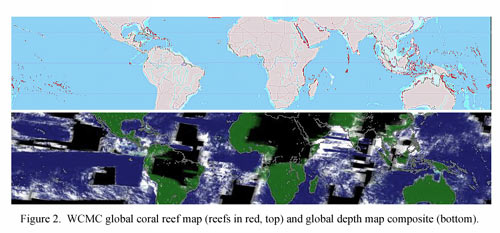
The World Conservation Monitoring Centre has produced a global map of coral reef distribution by compiling coral reef features into a multi-national, multi-source ARC/INFO GIS. The first set of maps was published in book form (UNEP/IUCN, 1988), and these have subsequently been updated and made available online (WCMC 1999). The WCMC approach has created the only existing global coral reef map, from which new estimates of coral reef area have been produced (Spalding and Grenfell, 1998). However problems with data availability, variation in scale, reef definition, accuracy of data (e.g. age of some charts) and human digitizing errors have meant that the final maps are of variable quality and utility. Coral reefs in 118 countries have been mapped and, while there are exceptions, the majority were prepared from sources at scales between 1:250,000 and 1:1,000,000. These sources range from navigational charts to national topographic maps, and occasionally specialized coral reef or shallow substrate maps. Apart from the latter categories the original data sources rarely include a definition of the areas mapped as "reefs". Typically the "reef" features are lines marking emergent or near-emergent reef crests, shallow coral reefs, and reef flats, i.e. navigational hazards. Deeper reefs are not well mapped. Despite their limitations these maps remain the best global representation of shallow coral reef areas produced to date.
For this project, the WCMC global coral reef map above was output in digital form in Robinson projection as a 39,462 ´ 20,016-pixel image representing the entire globe. The scale of the map pixels is approximately 1 km ´ 1 km in the tropics and 257,013 of these pixels represented reef areas. Latitudinal range of reef "pixels" extended from Bermuda (32.4802° N) to the Chatham Islands (44.0792° S).
2.2 ReefBase
ReefBase is a project by the International Center for Living Aquatic Resources Management (ICLARM) that aims to make reef information available to a wide audience in order to promote awareness and informed management of coral reef systems. ReefBase promotes the analysis of ecosystem health and integrity on coral reefs by facilitating the investigation of norms and bounds of key variables, developing guidelines for information gathering, and constructing national, regional and global status summaries. It is the official database of the Global Coral Reef Monitoring Network, and thus compiles the global network's results from assessments of status and trends in coral reefs and how people use the resources. In its current version (Version 3.0, McManus and Vergara, 1998) ReefBase locates over 8000 reefs, identifies related resources, describes marine protected areas and their features, and provides information on reef stresses, threats, management initiatives, reef-related socioeconomic variables and tourism. It also features the WCMC reef maps and low-resolution digitized versions of astronaut photographs of Earth from the NASA archives.
2.3 SeaWiFS
SeaWiFS (Sea-viewing Wide Field-of-View Sensor) was launched in August 1997 for routine global monitoring of the color of the ocean (SeaWiFS, undated; McClain et al., 1998). Although designed for chlorophyll measurement, the spectral range of information obtained allows a number of additional remote sensing applications including estimation of depth and bottom characteristics. SeaWiFS has an instantaneous field-of-view as narrow as 1.1 km per pixel (Local Area Coverage mode, LAC), and potential repeat coverage of every two days in the tropics. SeaWiFS has onboard storage capabilities and a network of over 65 receiving stations; the onboard storage capacity is particularly important for obtaining images of reefs in remote areas for later downlink to ground stations.
SeaWiFS data is collected, processed, archived and distributed by NASA to researchers worldwide. From 21 June through 26 September 1999, LAC data was collected systematically over tropical ocean areas with the objective of acquiring a body of imagery of reef areas worldwide. We now have coverage of at least one image over 90% of the reef-bearing tropical ocean (between 35° N and 35° S). An additional set of reef area scenes collected by ground stations around the globe during real-time transmission from the satellite (HRPT scenes) were also identified and incorporated into this project.
2.4 ASTRONAUT PHOTOGRAPHY OF EARTH
NASA astronauts have been photographing Earth through spacecraft windows ever since the beginning of human spaceflight. The photography is managed through Johnson Space Center's Office of Earth Sciences, and includes formal scientific investigations and informal "Earth Observations" objectives. Primarily consisting of 70-mm format color reversal film, the database maintained by the Office of Earth Sciences at Johnson Space Center (1999), currently contains over 375,000 frames. As of January 2000, we estimate that the database includes over 28,000 photographs of potential value for reef remote sensing (not too oblique, long lens, normal exposure and focus, center point within 200 km of a known reef area on the WCMC global map). Photography of reef areas from the Space Shuttle (and soon the International Space Station) will continue as part of Earth Science activities. Digitized photographs have been used for land cover classification with results comparable to those from Landsat (Webb et al., in press). Investigations of their use for coral reef habitat mapping are under way (S. Andréfouët et al., unpubl. data). Because astronauts visually select scenes as they photograph Earth, reef images from the archive tend to have relatively low cloud cover.
3.0 METHODS AND RESULTS
3.1 CORAL REEF MAPPING ALGORITHM FOR SeaWiFS DATA
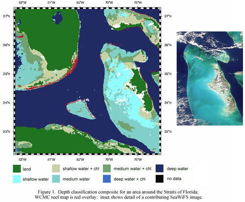
We generated a composite depth map (36,000 ´ 7,000 pixels from 35° N to 35° S) from SeaWiFS data using a classification algorithm (Table 1) and compositing of multiple scenes. Three depth intervals are used: shallow, medium, and deep (Figure 1). Shallow water is shallower than about 5 m, and deep water is greater than 20 m (the exact depth associated with the breaks depends on water clarity. The break between medium and deep water should be 20-30 m for all reefs).
Table 1. Classes Used in SeaWiFS Bottom Feature Map [†]
|
Rank |
Class |
Algorithm |
|---|---|---|
|
1 |
Missing data |
|
|
2 |
Clouds |
SeaDAS standard (Lt(865) > standard threshold) |
|
3 |
Land |
Rrs(670) < 0 |
|
4 |
Shallow + pigment |
Rrs(670) > 0.0015 and chl > 1.5 |
|
5 |
Shallow water |
Rrs(670) > 0.0015 |
|
6 |
Medium + pigment |
Rrs(555) > 0.0035 and chl > 1.5 |
|
7 |
Medium water |
Rrs(555) > 0.0035 |
|
8 |
Deep + pigment |
Rrs(555) < 0.0035 and > 0 and chl > 1.5 |
|
9 |
Deep water |
Rrs(555) < 0.0035 and > 0 |
|
|
|
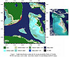
When each scene is processed, a pixel is added to the composite if the class at the pixel has a higher rank than found in the composite. This removes most effects of transient turbidity, as well as gradually clearing missing data and clouds[‡]. The current composite consists primarily of LAC data from 6 September 1997 – 16 September 1999, with some additional HRPT data; a total of 5299 individual scenes were processed to make the composite. When the WCMC map is overlaid on SeaWiFS depth map, discrepancies can be identified (Figure 2).
|
|
|
This algorithm has some limitations. The most severe is that chronically turbid water (as near major river plumes) cannot be separated from shallow water. The compositing would remove transient events, such as resuspension of sediments during strong wind events. Changes in bottom albedo are not fully addressed in this algorithm. Dense bottom vegetation (seagrass or algae) may lead to misclassification of a deeper depth. For example, shallow water with dense seagrass may be classified as medium depth water with pigment owing to the low albedo of the seagrass.
3.2 ASTRONAUT PHOTOGRAPHS AS BASE LAYERS FOR ReefBase GIS
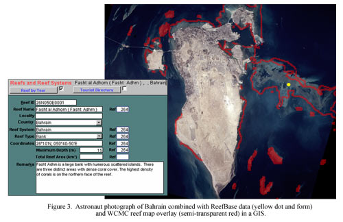
ReefBase is developing a new interface, which will present much of the database in a Geographic Information System (GIS) available both on the Web and on CD-ROM. Utilizing standardized software, protocols, and formats, this GIS is intended to improve the accessibility, compatibility, and use of the information contained in ReefBase. Generally, this system will enable users to display information stored in ReefBase on a scalable map, use search and query functions, and retrieve information from the database simply by clicking on any of the features displayed on the map (e.g. a coral reef, dive site, or marine protected area). We investigated the possibility of incorporating astronaut photographs into the GIS to allow their display as base images and the overlay of ReefBase map features.
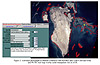
In a "ReefBase GIS Prototype" pilot project, astronaut photographs of Grand Cayman Island and Bahrain were identified and digitized from 2nd generation film at 1600 ppi using an Agfa Arcus II scanner, and saved in TIFF format. Although this resolution is less than the film resolving power for color reversal films used (Robinson et al., unpublished data), it was selected as an optimized solution to the trade-off between data storage and information content. Using Adobe Photoshop, some basic image enhancement procedures were performed, such as cropping, color balancing and brightness/contrast adjusting. This was done to make the images more suitable as visual base maps in the GIS, and to provide a level of standardization across images. Next, these images were imported in ER Mapper 5.5 for georeferencing. Ground control points selected from the World Vector Shoreline dataset (BODC, 1997) were used to perform polynomial rectification of the images to Geodetic Projection with WGS-84 datum and cell size of 0.0005 decimal degrees. These raster-datasets were then exported for use in the GIS (Figure 3). The yellow dot on the image represents a data point from the ReefBase coral reefs layer, which had been overlaid on the image. Clicking on this feature provides access to the database by opening the "Reefs and Reef Systems" data form.
|
|
|
For the first application of this prototype, an initial set of 750 astronaut photographs have been digitized and are being image-enhanced and georeferenced for inclusion in ReefBase. These images will serve as the first set of photographic base maps in the new ReefBase GIS interface.
3.3 GEOREFERENCING ASTRONAUT PHOTOGRAPHS FOR DATA DISTRIBUTION
In a second pilot project using astronaut photographs, the "Data Distribution Prototype," 30 astronaut photographs of reefs were digitized from 2nd generation film at 2400 ppi using an Agfa Arcus II scanner. We used the automatic density function in the scanning software to get color representation that was visually similar to the film, but made no other color adjustments. We georeferenced the images using a cleaned-up version of the World-Vector-Shoreline data digital coastline available as part of Generic Mapping Tools (GMT, Wessel and Smith, 1999) in a Plate Carree projection with 30 pixels = 0.01 degree. Georeferencing was done using ERDAS Imagine software (v. 8.3) and a 2nd order polynomial model. In a few cases the 2nd order polynomial gave poor results, and a 1st order model was used instead. The astronaut photographs were resampled to the pixel sizes in the coastline map. Because each photo was taken form a different altitude and different angle of obliquity, each photograph has a different spatial resolution. On average, the original images had average pixel sizes of 15 m and the georeferenced images had pixel sizes of 30-37 m (depending on longitude). In general, the surplus spatial resolution in the original image allowed for correction of obliquity in look angle during image resampling for georeferencing. Georeferenced images maintained much of the original information in the photographs (i.e., the images could potentially have been georeferenced at a larger scale to retain more information; methods for evaluating spatial resolution of astronaut photographs are in preparation). Although a contrast (brightness) stretch of two standard deviations is the default for displaying image colors in Imagine (ERDAS, Inc., 1997), most images were returned to a contrast stretch from minimum-maximum brightness before being exported in TIFF format for addition to the " Coral Reef Remote Sensing" Web site (see section 3.4). Using a contrast stretch from minimum to maximum provided a color representation that more closely approximated the original film colors, while the 2 SD stretch gave output images with very reduced levels of green tones.
In general, processing of a digital image required 20 minutes to 1 person-hour depending on the ease of matching coastline features from the reference map to the reefs in the image. For example, we had great difficulty in tying astronaut photographs of the Maldives to the reference coastlines because the reference map usually consisted of a few similar islets while the astronaut photograph showed extensive underwater detail that was difficult to distinguish form the islets. Similarly, we were unable to georeference photographs from the Great Barrier Reef to this reference map because the reference map sometimes did not show any subareal features at all. Such difficulties could be avoided by the use of more detailed reference maps.
3.4 INTERNET DATA FUSION AND DISTRIBUTION
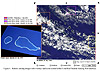
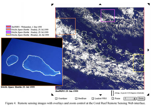
Users at the "Coral Reef Remote Sensing" prototype (http://seawifs.gsfc.nasa.gov/reefs) are presented with three global maps: (1) the most recent global composite of SeaWiFS one-kilometer data that have been passed through the depth-classification algorithm, (2) the WCMC global reef map, and (3) a locator map with coastlines and boxes representing images from various sensors which can be viewed with the interface. The user has control over which of these maps are displayed as the session continues.
The interface was designed to be able to include remotely sensed imagery from any platform and a variety of maps. Data included in our prototype (e.g., Figure 4) included SeaWiFS (1100 m pixels), MOS/IRS-P3 (500 m), digitized astronaut photography (10-50 m), Landsat TM (30 m), AVIRIS/NASA Aircraft (20 m), AISA NOAA Aircraft (5 m), and USGS Aircraft (1m). To access data on a specific area, the user clicks on one of the global maps. The interface then adds a more detailed map of the SeaWiFS depth classification for that area with boxes indicating the boundaries of any available remote sensing imagery and a legend of links to available imagery for that area. The user has the option of overlaying coastlines, the WCMC reef map, and Landsat Worldwide Reference System (WRS). The map can be panned and zoomed to best incorporate the area of interest. The user can also access and display matching maps extracted from the global bathymetry data (from ETOPO5/NOAA) or current NOAA Sea-surface Temperature "HotSpot" data (Toscano et al., 1999).
|
|
|
One of the first challenges of providing a single graphical user interface for georeferenced reef remote sensing data was to display data from different projections. We selected cylindrical equidistant (i.e., Plate Carree) as the projection for the Web interface. The WCMC global reef maps were reprojected from Robinson to Plate Carree using GMT software tools (and the default Akima's spline interpolant). Once initially georeferenced, astronaut photographs were readily added to the interface by knowing the locations of the corner points. Other remotely sensed imagery came in a variety of projections and formats, and were reprojected as needed.
The Web presentation of the remote sensing and ReefBase data is built around a directory that contains images of a known projection (Plate Carree), scale, and location. The area covered by each image in the directory is encoded in the image filename as a northern, southern, western, and eastern boundary (e.g. the WCMC map is ReefBase.coral.90N.90S.180W.180E.pbm; a SeaWiFS image of the Galapagos is S1999173175244.L1A_LAC.2N.2S.94W.87W.Galapagos.ppm). The scale of each image is computed from the image dimensions in pixels (which can be read from a header at the beginning of the file) and the dimensions in degrees which are parsed from the filename.
All image manipulations and overlays are performed on the fly when a Web client requests a page from the reefs.pl Common Gateway Interface (CGI) script. Coastlines are generated by the GMT program, pscoast. WCMC map overlays are cut out of the image file and scaled to match the selected image before being combined with that image. To date, over 100 remotely sensed images can be accessed via the prototype, including 18 astronaut photographs and 75 hand-selected SeaWiFS "true color" HRPT images.
4.0 DISCUSSION
In combining maps and remote sensing data from a variety of sources, we used a composite map based on SeaWiFS data as a backbone for distributing remotely sensed images. The Web-based distribution site allows for searching and retrieving images at a variety of resolutions and from a variety of sources. As additional data become available, they can be added to the database with direct access at the Web site. Such data include astronaut photography, Landsat imagery, MOS imagery, aircraft photographs and sensor observations as well as others.
For regions with poor chart information, the assembled georeferenced data can help in validating the positioning of reefs. For first-order corrections of global reef maps, the 1-km positional accuracy at nadir for SeaWiFS and the use of the associated depth classification maps can directly improve identification of the locations of reefs worldwide. The depth algorithm presented for SeaWiFS data is the first step in establishing detailed information on bathymetry and bottom characteristics in coral reef environments and illustrates the potential application of SeaWiFS data for improving reef mapping at a global scale. Future efforts could improve the final map product by refining compositing methods. Incorporation of more images into the composite would allow eventual completion of a complete global reef map. Future investigations could reconcile the two data sources and produce a consensus reef map.
Georeferenced astronaut photographs, whether in raw form or incorporated into a geographic information system, can be of great value to research efforts aimed at establishing estimates of coral reef locations and extent on national, regional and global scales. Astronaut photographs provide a unique source of moderate resolution (~30 m) reef remote sensing data because of their worldwide coverage and availability in the public domain. Although Landsat 7 data are likely to provide many advantages for detailed reef habitat classification (Andréfouët et al., 1999), astronaut photographs have advantages for applications requiring multiple images, where cloud cover is a problem, and where historical information is needed.
Astronaut photography provided particular advantages to ReefBase because it is relatively inexpensive to digitize, store, manipulate, and distribute sets of hundreds of images. The "ReefBase GIS Prototype" pilot project showed that astronaut photographs provide an excellent visual tool for displaying coral reef related information, adding value to the information contained in the database. On the other hand, the information contained in the database helped us to identify and interpret features on the images (see Figure 3). As the degree to which such photographs are suited for reef mapping and classification is better understood, the growing archive of high-resolution digital images can be a resource for the reef research community.
Although the prototype efforts we have described above represent a real advance in combining data sources and information about coral reefs on a global scale, much work remains to be done. For example, NOAA data on Sea Surface Temperature HotSpots and coral bleaching (Toscano et al., 1999) could be better integrated. Addition of Landsat 7 data now being systematically acquired for reef areas (Andréfouët et al., 1999) would also be important for reef researchers, but requires interagency data distribution agreements before implementation. Finally, coordination of georeferencing efforts for astronaut photographs so that images georeferenced for ReefBase can also be incorporated (in raw form) into the Remote Sensing of Coral Reefs distribution system would significantly increase access to this data source. As more and more reef remote sensing imagery is assembled, acquired, and combined, remote sensing can become a routinely applied tool for coral reef mapping at global, regional, and local scales.
5.0 ACKNOWLEDGEMENTS
We thank Barbara Boland for her work georeferencing astronaut photographs for the Data Distribution Prototype. C. A. Evans, J. W. McManus, and K. P. Lulla and provided constructive reviews.
6.0 REFERENCES
S. Andréfouët, F. Muller-Karger, and C. Hu, "Landsat 7: Long-term Large-scale Reef Studies," Reef Encounter, Vol. 26, pp. 27-29, 1999.
British Oceanographic Data Centre (BODC), General Bathymetric Chart of the Oceans (GEBCO-97) Digital Atlas. CD-ROM, United Kingdom, 1997.
D. Bryant, L. Burke, J. McManus, and M. Spalding, Reefs at Risk: A Map-based Indicator of Threats to the World's Coral Reefs, World Resources Institute, International Center for Living Aquatic Resources Management, World Conservation Monitoring Centre, and United Nations Environment Programme, Washington D. C., 1998.
Center for Marine Conservation, "Technical Issues Related to Coral Reef Remote Sensing and Workshop Recommendations," Center for Marine Conservation, Washington, D. C., June, 1999.
Cousteau Society, "Recommendations for Congress and the Administration," Calypso Log, p. 7, August 1999.
ERDAS, Inc., ERDAS Field Guide, 4th ed., ERDAS, Inc., Atlanta, Georgia, 1997.
O. Hoegh-Guldberg, "Climate Change, Coral Bleaching and the Future of the World's Coral Reefs," Marine and Freshwater Research, Vol. 50, pp. 839-866, 1999.
J. S. Kleypas, "Modeled Estimates of Global Reef Habitat and Carbonate Production Since the Last Glacial Maximum, Paleoceanography, Vol. 12, pp. 533-545, 1997.
Mapping and Information Synthesis Working Group, "Coral Reef Mapping Implementation Plan (2nd Draft)," U.S. Coral Reef Taskforce, Mapping and Information Synthesis Working Group, NOAA, NASA and USGS, Washington, D. C., November 1999. Also available at http://coralreef.gov/MIP.html .
S. Maritorena and J. E. O'Reilly, "Update on the Operational SeaWiFS Chlorophyll a Algorithm." In SeaWiFS Postlaunch Technical Report Series, NASA Technical Memorandum 1999-206892, S. B. Hooker and E. R. Firestone, eds., NASA Goddard Space Flight Center, Greenbelt, Maryland, in press.
C. R. McClain, M. L. Cleave, G. C. Feldman, W. W. Gregg, S. B. Hooker, and N. Kuring, "Science Quality SeaWiFS Data for Global Biosphere Research," Sea Technology, Vol. 39 No. 9, 1998.
J. W. McManus and M. Noordeloos, "Toward a Global Inventory of Coral Reefs (GICOR): Remote Sensing, International Cooperation and ReefBase," Proceedings of the Fifth International Conference on Remote Sensing of the Marine Environment, San Diego, California, 5-7 October 1998, Vol. I, pp. 83-89, 1998.
J. W. McManus and S. G. Vergara, editors, ReefBase: A Global Database on Coral Reefs and their Resources, Version 3.0, CD-ROM, International Center for Living Aquatic Resources Management, Manila, Philippines, 1998.
Office of Earth Sciences, NASA-Johnson Space Center, "Homepage," http://eol.jsc.nasa.gov , 13 Sep. 1999.
SeaWiFS, "Home Page," http://seawifs.gsfc.nasa.gov/SEAWIFS.html , NASA Goddard Space Flight Center.
S. V. Smith, "Coral Reef Area and Contributions of Reefs to Processes and Resources of the World's Oceans", Nature, Vol. 273, pp. 225-226, 1978.
M. Spalding and A. M. Grenfell, "New Estimates of Global and Regional Coral Reef Areas," Coral Reefs, Vol. 16, pp. 225-230, 1997.
R. P. Stumpf, G. Feldman, N. Kuring, B. Franz, E. Green, J. Robinson, “SeaWiFS spies reefs”, Reef Encounter, Vol. 26, pp. 29-30, 1999.
M. A. Toscano, A. E. Strong, and I. C. Guch, "New analyses for ocean HotSpots and coral reef bleaching," Reef Encounter, Vol. 26, p. 31, 1999.
UNEP/IUCN, Coral Reefs of the World, 3 Vols., World Conservation Union (IUCN), Gland, Switzerland, and United National Environment Programme (UNEP), Nairobi, Kenya, 1988.
U.S. Coral Reef Taskforce, "The National Action Plan to Conserve Coral Reefs," U.S. Department of the Interior and U.S. Department of Commerce, November 2, 1999. Also available at http://coralreef.gov/WG-reports.html . See also U.S. Department of the Interior and U.S. Department of Commerce, "Notice of Availability of Documents for Public Review and Comment," Federal Register, Vol. 64, pp. 67928-67929, 1999.
USDOC/NOAA/NESDIS, NOAA/CSC, and ICLARM, "Advancing Remote Sensing Technologies for the Sustainable Management of Coral Reefs, Resolution and Recommendations for Action," International Workshop On The Use Of Remote Sensing Tools For Mapping And Monitoring Coral Reefs, June 7-10, 1999, East-West Center, Honolulu, Hawaii, USA, http://www.coral.noaa.gov/corvil/coral_reefs/resolution.html .
P. Wessel and W. H. F. Smith., The Generic Mapping Tools Technical Reference and Cookbook, http://gmt.soest.hawaii.edu/gmt/doc/html/GMT_Docs/GMT_Docs.html, 1999.
World Conservation Monitoring Centre, "Marine Programme," http://www.wcmc.org.uk/marine/ , 18 June 1999.
[*] Presented at the Sixth International Conference on Remote Sensing for Marine and Coastal Environments, Charleston, South Carolina, 1-3 May 2000, http://www.erim-int.com/CONF/marine/MARINE.html . (Best of Plenary Session Award)
[†] Lt(865) is the total radiance at 865 nm. Rrs(670 or 555) is the remote sensing reflectance at the respective wavelength (670 and 555 nm bands). Chl is the chlorophyll concentration in µg/L from the standard algorithm (OC2 version 2, Maritorena and O'Reilly, in press).
[‡] However, as currently constructed, this compositing rule also leads to a gradual loss of pixels representing landmasses and shallow water. Thus, when future data are added to the current depth maps, we would employ a more sophisticated rule for identifying and replacing outlier depth values with new data while leaving valid values intact.
