Geographic Region: USA-TEXAS
Feature: MATAGORDA BAY
|
Geographic Region: USA-TEXAS Feature: MATAGORDA BAY |
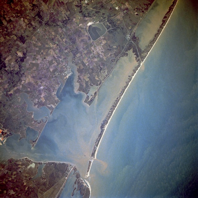 |
| STS61A-48-0071 Matagorda Bay, Texas, U.S.A. November 1985 Sediment-filled Matagorda Bay and its arm, Lavaca Bay, to the northwest, comprise the centerpiece of this near-vertical photograph. Matagorda Bay, an inlet of the Gulf of Mexico, was first visited in 1685 by French explorer Robert LaSalle on his last expedition. Although the region is often hit with tropical storms and hurricanes, the bay, 50 miles (80 kilometers) long and 3 to 12 miles (5 to 19 kilometers) wide, is generally protected from the gulf by Matagorda Peninsula, a long sandspit, at the west end of which is the entrance to Matagorda Bay through Cavallo Pass; farther west and mostly out of the photograph is Matagorda Island, a sandbar on which Matagorda State Park is located. The small city of Port O'Connor, north of Cavallo Pass, is also discernible. At the east end of the bay is the small delta of the Colorado River, which is 900 miles (1448 kilometers) long and rises in the Staked Plains of northwest Texas. North of the delta, a large holding pond for a nuclear power plant can be seen. Although mostly a cattle-raising region, agriculture (rice, cotton, grain, corn, truck crops, fruit, dairy products, livestock, and poultry) is prevalent. The region around the bay is also noted for its fishing industries. |
| Images: | All Available Images Low-Resolution 127k |
|
| Mission: | STS61A |
|
| Roll - Frame: | 48 - 71 |
|
| Geographical Name: | USA-TEXAS |
|
| Features: | MATAGORDA BAY |
|
| Center Lat x Lon: | 28.5N x 96W |
|
| Film Exposure: | N | N=Normal exposure, U=Under exposed, O=Over exposed, F=out of Focus |
| Percentage of Cloud Cover-CLDP: | 0 |
|
| Camera:: | HB |
|
| Camera Tilt: | 10 | LO=Low Oblique, HO=High Oblique, NV=Near Vertical |
| Camera Focal Length: | 250 |
|
| Nadir to Photo Center Direction: | S | The direction from the nadir to the center point, N=North, S=South, E=East, W=West |
| Stereo?: | N | Y=Yes there is an adjacent picture of the same area, N=No there isn't |
| Orbit Number: | 64 |
|
| Date: | 19851103 | YYYYMMDD |
| Time: | 164024 | GMT HHMMSS |
| Nadir Lat: | 29.0N |
Latitude of suborbital point of spacecraft |
| Nadir Lon: | 96W |
Longitude of suborbital point of spacecraft |
| Sun Azimuth: | 151 | Clockwise angle in degrees from north to the sun measured at the nadir point |
| Space Craft Altitude: | 177 | nautical miles |
| Sun Elevation: | 41 | Angle in degrees between the horizon and the sun, measured at the nadir point |
| Land Views: | COAST, ISLAND |
|
| Water Views: | BAY, RIVER, SEDIMENT, INLET |
|
| Atmosphere Views: | |
|
| Man Made Views: | AGRICULTURE |
|
| City Views: | |
|
Photo is not associated with any sequences | ||
| NASA Home Page |
JSC Home Page |
JSC Digital Image Collection |
Earth Science & Remote Sensing |
|
This service is provided by the International Space Station program and the JSC Earth Science & Remote Sensing Unit, ARES Division, Exploration Integration Science Directorate.

|