Geographic Region: JAPAN
Feature: NAGOYA
|
Geographic Region: JAPAN Feature: NAGOYA |
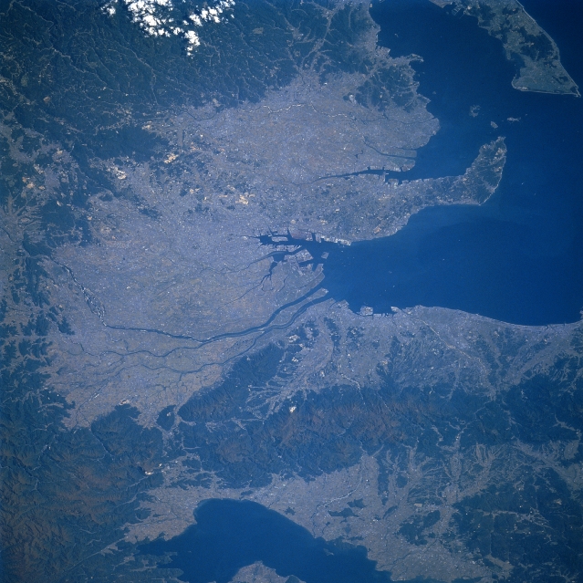 |
| STS61A-44-0097 Nagoya, Honshu, Japan November 1985 Located along the south central coast of Honshu, Nagoya, one of Japan's major industrial centers, can be located in the center of this west-looking view. This important port city is strategically located at the northeast end of Ise Bay (note the extensive harbor facilities slightly below the center of the picture), as well as being located between the larger Kobe/Osaka and Tokyo/Yokahmana metroplexes, west and east respectively (not in this image). Nagoya is sited on a densely populated (over 2 million people), low-lying, alluvial plain that is surrounded by volcanic mountains (darker landscape). Several other industrial cities that are situated around the periphery of Ise Bay blend together to give the appearance of one urban area (lighter colored landscape). There is some farming activity where topography allows which also adds to the overall lighter colored terrain. Several short-flowing rivers, including the Nagara River, drain southward and enter the northern end of Ise Bay west of Nagoya. Lake Biwa is the large lake west of the mountains (top center). |
| Images: | All Available Images Low-Resolution 353k |
|
| Mission: | STS61A |
|
| Roll - Frame: | 44 - 97 |
|
| Geographical Name: | JAPAN |
|
| Features: | NAGOYA |
|
| Center Lat x Lon: | 35.0N x 136.5E |
|
| Film Exposure: | N | N=Normal exposure, U=Under exposed, O=Over exposed, F=out of Focus |
| Percentage of Cloud Cover-CLDP: | 5 |
|
| Camera:: | HB |
|
| Camera Tilt: | 47 | LO=Low Oblique, HO=High Oblique, NV=Near Vertical |
| Camera Focal Length: | 250 |
|
| Nadir to Photo Center Direction: | W | The direction from the nadir to the center point, N=North, S=South, E=East, W=West |
| Stereo?: | N | Y=Yes there is an adjacent picture of the same area, N=No there isn't |
| Orbit Number: | 54 |
|
| Date: | 19851103 | YYYYMMDD |
| Time: | 013138 | GMT HHMMSS |
| Nadir Lat: | 34.1N |
Latitude of suborbital point of spacecraft |
| Nadir Lon: | 139.6E |
Longitude of suborbital point of spacecraft |
| Sun Azimuth: | 163 | Clockwise angle in degrees from north to the sun measured at the nadir point |
| Space Craft Altitude: | 178 | nautical miles |
| Sun Elevation: | 39 | Angle in degrees between the horizon and the sun, measured at the nadir point |
| Land Views: | PLAIN, FOREST |
|
| Water Views: | BAY, RIVER, LAKE |
|
| Atmosphere Views: | |
|
| Man Made Views: | URBAN AREA |
|
| City Views: | |
|
Photo is not associated with any sequences | ||
| NASA Home Page |
JSC Home Page |
JSC Digital Image Collection |
Earth Science & Remote Sensing |
|
This service is provided by the International Space Station program and the JSC Earth Science & Remote Sensing Unit, ARES Division, Exploration Integration Science Directorate.

|