Geographic Region: INDONESIA
Feature: BORNEO
|
Geographic Region: INDONESIA Feature: BORNEO |
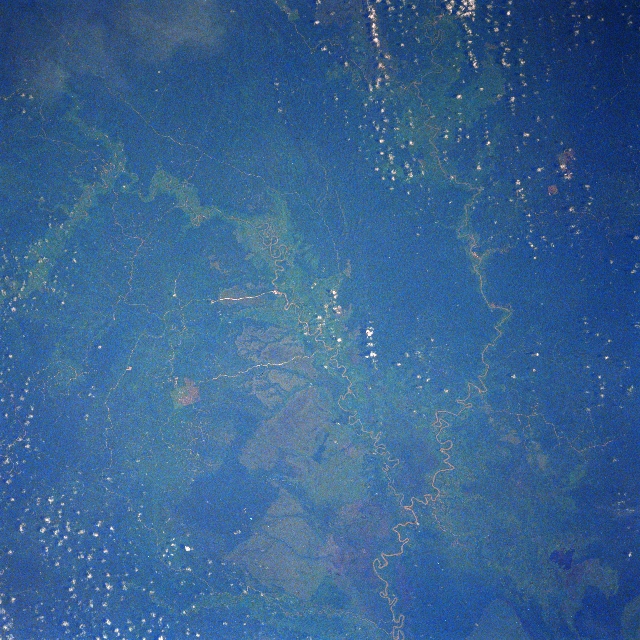 |
| STS61A-44-0090 East Kalimantan, Indonesia November 1985 Located near the central east coast of East Kalimantan, this once totally tropical rainforest landscape (darker areas) now exhibits the impact of recent human development (lighter-colored areas). The lighter-colored corridors that have been cleared for agriculture tend to follow the severely meandering rivers (light-colored, linear features). Several roads can be traced across jungle-covered terrain, connecting developing agricultural sites and towns (also light-colored, linear features). The uniform-looking (color wise) vegetative cover (bottom center) appears to be the result of the development of large plantations. The confluence of the Marah River (more easterly) and Kindjau River can be seen near the bottom center (lower right quadrant). Almost the entire bottom third of the image is a flat, swampy area. A lake (dark feature) is visible near the bottom right corner of the image. |
| Images: | All Available Images Low-Resolution 391k |
|
| Mission: | STS61A |
|
| Roll - Frame: | 44 - 90 |
|
| Geographical Name: | INDONESIA |
|
| Features: | BORNEO |
|
| Center Lat x Lon: | .5N x 116.5E |
|
| Film Exposure: | N | N=Normal exposure, U=Under exposed, O=Over exposed, F=out of Focus |
| Percentage of Cloud Cover-CLDP: | 20 |
|
| Camera:: | HB |
|
| Camera Tilt: | 12 | LO=Low Oblique, HO=High Oblique, NV=Near Vertical |
| Camera Focal Length: | 250 |
|
| Nadir to Photo Center Direction: | SW | The direction from the nadir to the center point, N=North, S=South, E=East, W=West |
| Stereo?: | Y | Y=Yes there is an adjacent picture of the same area, N=No there isn't |
| Orbit Number: | 54 |
|
| Date: | 19851103 | YYYYMMDD |
| Time: | 012122 | GMT HHMMSS |
| Nadir Lat: | 1.0N |
Latitude of suborbital point of spacecraft |
| Nadir Lon: | 116.9E |
Longitude of suborbital point of spacecraft |
| Sun Azimuth: | 114 | Clockwise angle in degrees from north to the sun measured at the nadir point |
| Space Craft Altitude: | 175 | nautical miles |
| Sun Elevation: | 48 | Angle in degrees between the horizon and the sun, measured at the nadir point |
| Land Views: | FOREST |
|
| Water Views: | RIVER |
|
| Atmosphere Views: | |
|
| Man Made Views: | |
|
| City Views: | |
|
Photo is not associated with any sequences | ||
| NASA Home Page |
JSC Home Page |
JSC Digital Image Collection |
Earth Science & Remote Sensing |
|
This service is provided by the International Space Station program and the JSC Earth Science & Remote Sensing Unit, ARES Division, Exploration Integration Science Directorate.

|