
Geographic Region: CANADA-Q
Feature: SAINT LAWRENCE RIVER
|
Geographic Region: CANADA-Q Feature: SAINT LAWRENCE RIVER |
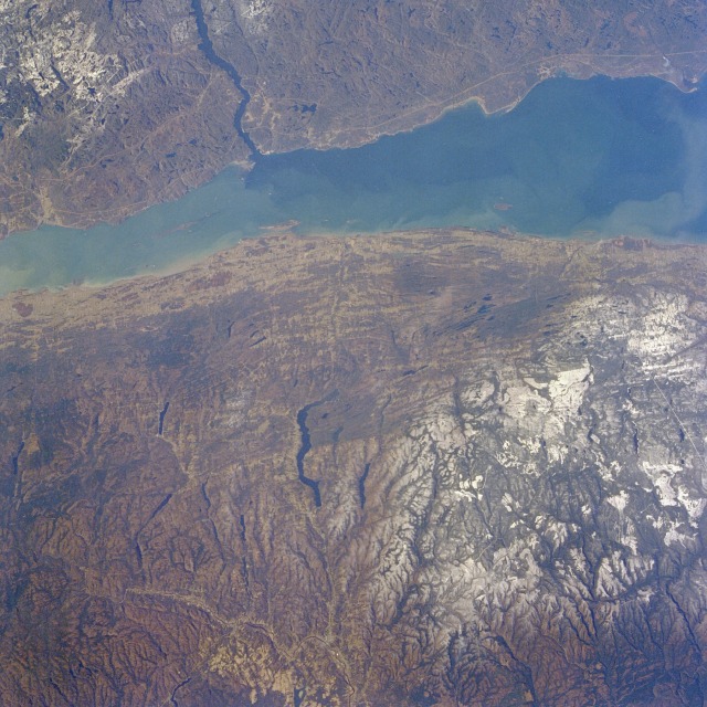 |
| STS61A-33-0057 Saint Lawrence River, Quebec, Canada November 1985 A 60-mile (97-kilometer) stretch of the Saint Lawrence River as it flows northeast toward the Gulf of Saint Lawrence and then into the Atlantic Ocean can be seen in this near-vertical photograph. As the river flows northeast, it increases in width from approximately 12 miles (20 kilometers) to almost 30 miles (50 kilometers) at its widest point. Bounded on either side by the Canadian province of Quebec, the Saint Lawrence River is the connecting link for shipping traffic between the Atlantic Ocean and the Great Lakes. The area shown in this photograph was covered by the Laurentide Ice Sheet that covered the northeastern part of North America 10 000 to 15 000 years ago. The effects of the erosive power of the ice sheet and the widespread scouring caused by the movement of the continental ice sheets are evident on this landscape. The glaciers created a chaotic drainage system both north and south of the river. A smooth-looking relief with many lakes is a remnant from the glacial action. Both the Laurentian Mountains north of the Saint Lawrence River and the Notre Dame Mountains south of the river are ancient, worn, low mountains with average elevations of approximately 2000 feet (610 meters); traces of snow are observed in both mountain ranges. The thin linear features primarily north of the river are power line rights-of-way. The Saguenay River enters the Saint Lawrence River from the northwest, and Lake Temisquate is the elongated lake south of the river. |
| Images: | All Available Images Low-Resolution 150k |
|
| Mission: | STS61A |
|
| Roll - Frame: | 33 - 57 |
|
| Geographical Name: | CANADA-Q |
|
| Features: | SAINT LAWRENCE RIVER |
|
| Center Lat x Lon: | 48.0N x 69W |
|
| Film Exposure: | N | N=Normal exposure, U=Under exposed, O=Over exposed, F=out of Focus |
| Percentage of Cloud Cover-CLDP: | 0 |
|
| Camera:: | HB |
|
| Camera Tilt: | 25 | LO=Low Oblique, HO=High Oblique, NV=Near Vertical |
| Camera Focal Length: | 100 |
|
| Nadir to Photo Center Direction: | W | The direction from the nadir to the center point, N=North, S=South, E=East, W=West |
| Stereo?: | Y | Y=Yes there is an adjacent picture of the same area, N=No there isn't |
| Orbit Number: | 17 |
|
| Date: | 19851031 | YYYYMMDD |
| Time: | 172756 | GMT HHMMSS |
| Nadir Lat: | 47.4N |
Latitude of suborbital point of spacecraft |
| Nadir Lon: | 67.7W |
Longitude of suborbital point of spacecraft |
| Sun Azimuth: | 199 | Clockwise angle in degrees from north to the sun measured at the nadir point |
| Space Craft Altitude: | 181 | nautical miles |
| Sun Elevation: | 26 | Angle in degrees between the horizon and the sun, measured at the nadir point |
| Land Views: | PLAIN, HILL |
|
| Water Views: | RIVER, CHANNEL |
|
| Atmosphere Views: | |
|
| Man Made Views: | |
|
| City Views: | |
|
Photo is not associated with any sequences | ||
| NASA Home Page |
JSC Home Page |
JSC Digital Image Collection |
Earth Science & Remote Sensing |
|
This service is provided by the International Space Station program and the JSC Earth Science & Remote Sensing Unit, ARES Division, Exploration Integration Science Directorate.

|