
Geographic Region: USA-NEW YORK
Feature: ALBANY
|
Geographic Region: USA-NEW YORK Feature: ALBANY |
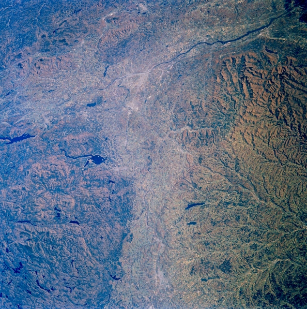 |
| STS61A-33-0044 Mohawk/Hudson River Valleys, New York November 1985 The valleys of the Mohawk and Hudson Rivers can be seen in this east-looking view. The Mohawk River, 148 miles (238 km) long enters the scene near Utica (bottom center) and flows east emptying into the Hudson River north of Albany (midway between the center and upper center of the image). The Mohawk River is the Hudson River's largest tributary. The New York State Barge Canal starts at the mouth of the Mohawk River and goes westward to near Rome, New York. This canal links the Hudson River with the Great Lakes. The beautiful and fertile Mohawk River Valley has long been an important transportation route from the cities of the northeast to the west. North (left) of the Mohawk River are the rugged Adirondack Mountains. The Great Sacandaga Lake is visible to the left of the center of the image. To the south (right) of the Mohawk River and covering the center and lower portions of the image are the beautiful, forested Catskill Mountains. Setting in the Albany Plain (former Lake Albany) is the valley of the north-south flowing Hudson River. The Taconic Hills lie to the east of the Hudson River in the upper left quadrant of the image. |
| Images: | All Available Images Low-Resolution 438k |
|
| Mission: | STS61A |
|
| Roll - Frame: | 33 - 44 |
|
| Geographical Name: | USA-NEW YORK |
|
| Features: | ALBANY |
|
| Center Lat x Lon: | 43.0N x 74.5W |
|
| Film Exposure: | N | N=Normal exposure, U=Under exposed, O=Over exposed, F=out of Focus |
| Percentage of Cloud Cover-CLDP: | 0 |
|
| Camera:: | HB |
|
| Camera Tilt: | 26 | LO=Low Oblique, HO=High Oblique, NV=Near Vertical |
| Camera Focal Length: | 100 |
|
| Nadir to Photo Center Direction: | NE | The direction from the nadir to the center point, N=North, S=South, E=East, W=West |
| Stereo?: | Y | Y=Yes there is an adjacent picture of the same area, N=No there isn't |
| Orbit Number: | 17 |
|
| Date: | 19851031 | YYYYMMDD |
| Time: | 172555 | GMT HHMMSS |
| Nadir Lat: | 42.3N |
Latitude of suborbital point of spacecraft |
| Nadir Lon: | 75.8W |
Longitude of suborbital point of spacecraft |
| Sun Azimuth: | 191 | Clockwise angle in degrees from north to the sun measured at the nadir point |
| Space Craft Altitude: | 180 | nautical miles |
| Sun Elevation: | 32 | Angle in degrees between the horizon and the sun, measured at the nadir point |
| Land Views: | MOUNTAIN, VALLEY, FAULT, FOREST |
|
| Water Views: | RIVER, LAKE |
|
| Atmosphere Views: | |
|
| Man Made Views: | |
|
| City Views: | |
|
Photo is not associated with any sequences | ||
| NASA Home Page |
JSC Home Page |
JSC Digital Image Collection |
Earth Science & Remote Sensing |
|
This service is provided by the International Space Station program and the JSC Earth Science & Remote Sensing Unit, ARES Division, Exploration Integration Science Directorate.

|