Geographic Region: KAZAKHSTAN
Feature: ARAL SEA
|
Geographic Region: KAZAKHSTAN Feature: ARAL SEA |
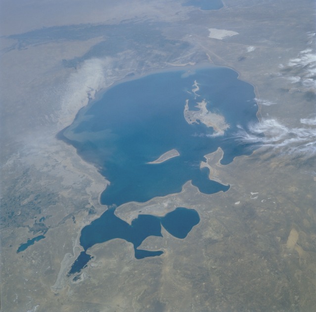 |
| STS51F-36-59 Aral Sea, Kazakhstan and Uzbekistan July 1985 The Aral Sea, the fourth largest lake in the world, can be seen in this low-oblique, south-looking view. When this photograph was taken, the Aral Sea covered an area of approximately 26 000 square miles (67 000 square kilometers), was approximately 260 miles (420 kilometers) long, 175 miles (280 kilometers) wide, and had an average depth of 33 feet (10 meters) and a maximum depth of 220 feet (70 meters). Separated from the Caspian Sea millions of years ago and landlocked at the center of a broad basin, the Aral Sea is surrounded on all sides by desert or steppe. Although two major rivers feed the sea, the Amu Darya from the south and the Syr Darya from the northeast, there is no outlet. Before 1960, the sea was only slightly saline. The development of agricultural irrigation projects along both river courses in the late 1950s impeded the flow of water, and little or no fresh water reaches the sea now. With reduced quantities of fresh water and constant evaporation, the sea has become more saline and has shrunk drastically since the early 1960s. It has also become polluted with numerous pesticides and fertilizers. Two islands can be seen emerging from the Aral Sea. Barsa-Kel'mes Island is the pointed island in the north-central part of the sea; Vozrozhdeniya Island is the broad island in the west part of the sea. To the south, the darker colored, irrigated agricultural lands along the Amu Darya are visible. East of the sea near the shoreline, a duststorm (whitish area) of exposed sea bottom sediments can be seen moving southwestward toward the darker agricultural areas. Sea bottom sediments and past shorelines are visible (whitish-gray areas) along all parts of the sea and the emerging islands. (See STS047-079-083 for a comparison of how the Aral Sea has continued to shrink in only seven years.) |
| Images: | All Available Images Low-Resolution 71k |
|
| Mission: | STS51F |
|
| Roll - Frame: | 36 - 59 |
|
| Geographical Name: | KAZAKHSTAN |
|
| Features: | ARAL SEA |
|
| Center Lat x Lon: | 45.5N x 60.0E |
|
| Film Exposure: | N | N=Normal exposure, U=Under exposed, O=Over exposed, F=out of Focus |
| Percentage of Cloud Cover-CLDP: | 10 |
|
| Camera:: | HB |
|
| Camera Tilt: | LO | LO=Low Oblique, HO=High Oblique, NV=Near Vertical |
| Camera Focal Length: | 100 |
|
| Nadir to Photo Center Direction: | S | The direction from the nadir to the center point, N=North, S=South, E=East, W=West |
| Stereo?: | N | Y=Yes there is an adjacent picture of the same area, N=No there isn't |
| Orbit Number: | 122 |
|
| Date: | 19850806 | YYYYMMDD |
| Time: | 121128 | GMT HHMMSS |
| Nadir Lat: | 49.5N |
Latitude of suborbital point of spacecraft |
| Nadir Lon: | 61.4E |
Longitude of suborbital point of spacecraft |
| Sun Azimuth: | 260 | Clockwise angle in degrees from north to the sun measured at the nadir point |
| Space Craft Altitude: | 178 | nautical miles |
| Sun Elevation: | 30 | Angle in degrees between the horizon and the sun, measured at the nadir point |
| Land Views: | DESERT, BASIN, PLATEAU |
|
| Water Views: | LAKE, SEDIMENT, RIVER, DELTA |
|
| Atmosphere Views: | DUST |
|
| Man Made Views: | AGRICULTURE, POLLUTION |
|
| City Views: | |
|
Associated Photos in Sequence:  Photo #: STS51F-36-59 ** Currently displayed photo ** Photo #: STS51F-36-59 ** Currently displayed photo ** Description: ARAL SEA-1985; DECREASING LAKE LEVELS Sequence ID: 1A  Photo #: STS047-79-83 Photo #: STS047-79-83Description: ARAL SEA-1992; DECREASING LAKE LEVELS Sequence ID: 1B  Photo #: STS059-L22-140 Photo #: STS059-L22-140Description: ARAL SEA-1994; DECREASING LAKE LEVELS Sequence ID: 1C | ||
| NASA Home Page |
JSC Home Page |
JSC Digital Image Collection |
Earth Science & Remote Sensing |
|
This service is provided by the International Space Station program and the JSC Earth Science & Remote Sensing Unit, ARES Division, Exploration Integration Science Directorate.

|