
Geographic Region: USA-TEXAS
Feature: AUSTIN
|
Geographic Region: USA-TEXAS Feature: AUSTIN |
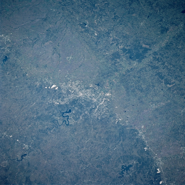 |
| STS095-716-46 Balcones Escarpment, Austin, Texas November 1998 The Balcones Escarpment can be seen extending from near Temple (upper left) through Austin (center of the image) and to just south of New Braunfels (bottom right). The Balcones Escarpment forms a distinct boundary between the topographically higher Edwards Plateau (dark, left side of the image) and the Gulf Coastal Plain (right). The escarpment, formed by faulting and erosion, extends from the Rio Grande near Del Rio eastward to San Antonio, northeastward to Austin, and finally northward toward the Red River. The terrain west and north of the escarpment is generally rounded with wooded hills and numerous small river valleys. The escarpment is highest near Del Rio (1000 feet, 300 meters). Austin, the capitol of Texas, is located on the intersection of the Balcones Escarpment and the Colorado River. Interstate Highway 35 parallels a section of the Balcones Escarpment from San Antonio to Temple. Lake Travis visible to the west-northwest of Austin. Canyon Lake can be seen to the right bottom center of the image. In the upper right corner, the letters "LOECKE" can be identified. The letters are 3100 ft high and were formed by clearing forest to spell the name of the landowner during the summer of 1997. The remaining adjacent forest is Buescher State Park. |
| Images: | All Available Images Low-Resolution 382k |
|
| Mission: | STS095 |
|
| Roll - Frame: | 716 - 46 |
|
| Geographical Name: | USA-TEXAS |
|
| Features: | AUSTIN |
|
| Center Lat x Lon: | 30.5N x 97.5W |
|
| Film Exposure: | N | N=Normal exposure, U=Under exposed, O=Over exposed, F=out of Focus |
| Percentage of Cloud Cover-CLDP: | 0 |
|
| Camera:: | HB |
|
| Camera Tilt: | 37 | LO=Low Oblique, HO=High Oblique, NV=Near Vertical |
| Camera Focal Length: | 250 |
|
| Nadir to Photo Center Direction: | NE | The direction from the nadir to the center point, N=North, S=South, E=East, W=West |
| Stereo?: | N | Y=Yes there is an adjacent picture of the same area, N=No there isn't |
| Orbit Number: | 61 |
|
| Date: | 19981102 | YYYYMMDD |
| Time: | 185833 | GMT HHMMSS |
| Nadir Lat: | 28.6N |
Latitude of suborbital point of spacecraft |
| Nadir Lon: | 100.7W |
Longitude of suborbital point of spacecraft |
| Sun Azimuth: | 191 | Clockwise angle in degrees from north to the sun measured at the nadir point |
| Space Craft Altitude: | 293 | nautical miles |
| Sun Elevation: | 46 | Angle in degrees between the horizon and the sun, measured at the nadir point |
| Land Views: | ESCARPMENT, HILL |
|
| Water Views: | LAKE, RIVER |
|
| Atmosphere Views: | |
|
| Man Made Views: | URBAN AREA, AGRICULTURE, MINING, HIGHWAY |
|
| City Views: | AUSTIN |
|
Photo is not associated with any sequences | ||
| NASA Home Page |
JSC Home Page |
JSC Digital Image Collection |
Earth Science & Remote Sensing |
|
This service is provided by the International Space Station program and the JSC Earth Science & Remote Sensing Unit, ARES Division, Exploration Integration Science Directorate.

|