Geographic Region: USA-TEXAS
Feature: HOUSTON
|
Geographic Region: USA-TEXAS Feature: HOUSTON |
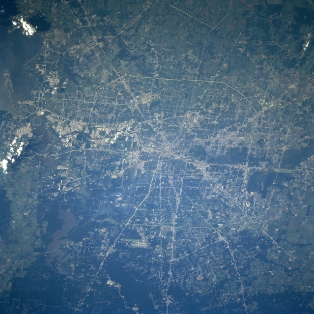 |
| STS094-753-046 Houston, Texas July 1997 The city of Houston is the fourth largest city in the United States. Houston is a port of entry and has the second busiest port in the United States. The city is a major financial, commercial, manufacturing, and transportation center in the southwestern United States. Houston boasts one of the worlds most comprehensive and competent medical centers. The city is located on a delta that was formed during the end of the last ice age some 10000-15000 years ago. Numerous Interstate Highways and other major transportation routes are visible traversing through and around the city. The runways of the George Bush Intercontinental Airport are discernible midway between the center and the bottom center of the image. Just to the left (east) of the airport, the sediment-laden waters of Lake Houston can be seen. A small part of upper Galveston Bay is visible in the upper left corner of the image. |
| Images: | All Available Images Low-Resolution 364k |
|
| Mission: | STS094 |
|
| Roll - Frame: | 753 - 46 |
|
| Geographical Name: | USA-TEXAS |
|
| Features: | HOUSTON |
|
| Center Lat x Lon: | 29.5N x 95.5W |
|
| Film Exposure: | N | N=Normal exposure, U=Under exposed, O=Over exposed, F=out of Focus |
| Percentage of Cloud Cover-CLDP: | 5 |
|
| Camera:: | HB |
|
| Camera Tilt: | 30 | LO=Low Oblique, HO=High Oblique, NV=Near Vertical |
| Camera Focal Length: | 250 |
|
| Nadir to Photo Center Direction: | NW | The direction from the nadir to the center point, N=North, S=South, E=East, W=West |
| Stereo?: | Y | Y=Yes there is an adjacent picture of the same area, N=No there isn't |
| Orbit Number: | 173 |
|
| Date: | 19970712 | YYYYMMDD |
| Time: | 130721 | GMT HHMMSS |
| Nadir Lat: | 28.6N |
Latitude of suborbital point of spacecraft |
| Nadir Lon: | 94.3W |
Longitude of suborbital point of spacecraft |
| Sun Azimuth: | 75 | Clockwise angle in degrees from north to the sun measured at the nadir point |
| Space Craft Altitude: | 157 | nautical miles |
| Sun Elevation: | 20 | Angle in degrees between the horizon and the sun, measured at the nadir point |
| Land Views: | PLAIN |
|
| Water Views: | BAY, LAKE, SEDIMENT |
|
| Atmosphere Views: | |
|
| Man Made Views: | URBAN AREA, AIRPORT, HIGHWAY |
|
| City Views: | HOUSTON |
|
Photo is not associated with any sequences | ||
| NASA Home Page |
JSC Home Page |
JSC Digital Image Collection |
Earth Science & Remote Sensing |
|
This service is provided by the International Space Station program and the JSC Earth Science & Remote Sensing Unit, ARES Division, Exploration Integration Science Directorate.

|