Geographic Region: BRAZIL
Feature: BRANCO RIVER, ACRE RIVER, DEFOR.
|
Geographic Region: BRAZIL Feature: BRANCO RIVER, ACRE RIVER, DEFOR. |
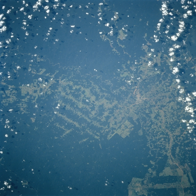 |
| STS094-746-011 Rio Branco, Acre State, Brazil July 1997 The rural town of Rio Branco (concentrated light area left of center), located near the eastern end of Acre State, is visible on this image that shows both cleared lands (lighter green terrain) and the remaining rainforest (darker green). The runway of Presidente Medici Airport (light colored, linear feature) south of the town helps to identify the location of the small urban area. The deforested areas show a variety of clear-cutting patterns that include large angular fields (possibly plantations), paralleling cuts through the densely forested landscape, and randomly spaced, generally smaller fields. |
| Images: | All Available Images Low-Resolution 340k |
|
| Mission: | STS094 |
|
| Roll - Frame: | 746 - 11 |
|
| Geographical Name: | BRAZIL |
|
| Features: | BRANCO RIVER, ACRE RIVER, DEFOR. |
|
| Center Lat x Lon: | N x E |
|
| Film Exposure: | N | N=Normal exposure, U=Under exposed, O=Over exposed, F=out of Focus |
| Percentage of Cloud Cover-CLDP: | 10 |
|
| Camera:: | HB |
|
| Camera Tilt: | LO=Low Oblique, HO=High Oblique, NV=Near Vertical |
|
| Camera Focal Length: | 100 |
|
| Nadir to Photo Center Direction: | The direction from the nadir to the center point, N=North, S=South, E=East, W=West |
|
| Stereo?: | Y | Y=Yes there is an adjacent picture of the same area, N=No there isn't |
| Orbit Number: | 145 |
|
| Date: | 19970710 | YYYYMMDD |
| Time: | 192537 | GMT HHMMSS |
| Nadir Lat: | 10S |
Latitude of suborbital point of spacecraft |
| Nadir Lon: | 68W |
Longitude of suborbital point of spacecraft |
| Sun Azimuth: | 308 | Clockwise angle in degrees from north to the sun measured at the nadir point |
| Space Craft Altitude: | 163 | nautical miles |
| Sun Elevation: | 38 | Angle in degrees between the horizon and the sun, measured at the nadir point |
| Land Views: | FOREST |
|
| Water Views: | RIVER |
|
| Atmosphere Views: | |
|
| Man Made Views: | DEFORESTATION |
|
| City Views: | |
|
Photo is not associated with any sequences | ||
| NASA Home Page |
JSC Home Page |
JSC Digital Image Collection |
Earth Science & Remote Sensing |
|
This service is provided by the International Space Station program and the JSC Earth Science & Remote Sensing Unit, ARES Division, Exploration Integration Science Directorate.

|