
Geographic Region: USA-MISSISSIPPI
Feature: MISSISSIPPI R.,AR. RIVER
|
Geographic Region: USA-MISSISSIPPI Feature: MISSISSIPPI R.,AR. RIVER |
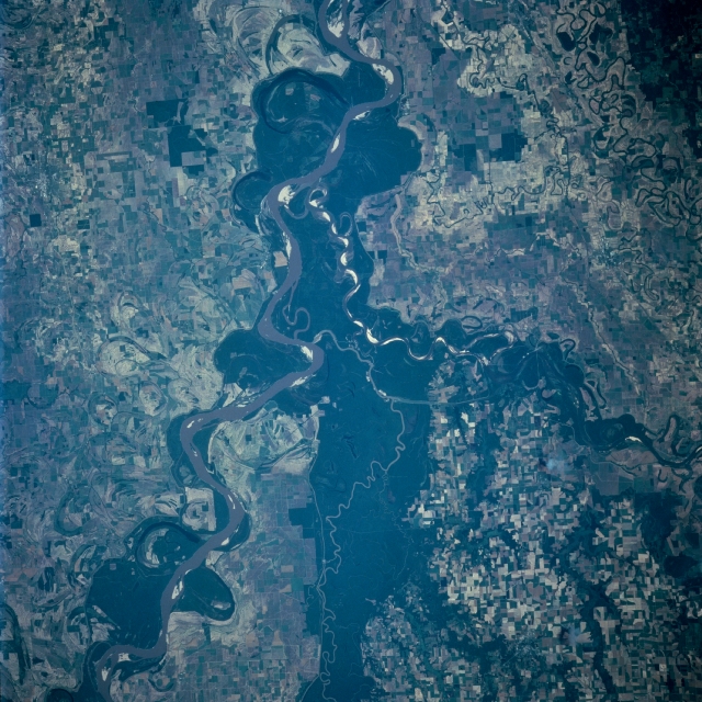 |
| STS091-707-024 White, Arkansas, and Mississippi Rivers, Mississippi June 1998 Near the center of the image is the confluence of the White, Arkansas, and Mississippi Rivers. The sediment-laden Mississippi River traverses the scene from the upper left (north) to the right center (south) of the image. The Arkansas River, 1450 miles (2335 km) long, enters the scene just to the left of the center bottom (west) of the image. The Arkansas River navigation system begins here making the river navigable northwestward 500 miles (805 km) upstream past Little Rock, Arkansas to Tulsa, Oklahoma. The 690 mile (1110 km) long White River enters the scene at the left center of the image. Forest cover (darker areas) abounds on either side of the river. Along the Mississippi River numerous oxbow patterns are visible. These patterns represent the changes in the course the river has taken over thousands of years. |
| Images: | All Available Images Low-Resolution 385k |
|
| Mission: | STS091 |
|
| Roll - Frame: | 707 - 24 |
|
| Geographical Name: | USA-MISSISSIPPI |
|
| Features: | MISSISSIPPI R.,AR. RIVER |
|
| Center Lat x Lon: | 34.0N x 91W |
|
| Film Exposure: | N | N=Normal exposure, U=Under exposed, O=Over exposed, F=out of Focus |
| Percentage of Cloud Cover-CLDP: | 0 |
|
| Camera:: | HB |
|
| Camera Tilt: | 22 | LO=Low Oblique, HO=High Oblique, NV=Near Vertical |
| Camera Focal Length: | 250 |
|
| Nadir to Photo Center Direction: | E | The direction from the nadir to the center point, N=North, S=South, E=East, W=West |
| Stereo?: | N | Y=Yes there is an adjacent picture of the same area, N=No there isn't |
| Orbit Number: | 79 |
|
| Date: | 19980607 | YYYYMMDD |
| Time: | 212752 | GMT HHMMSS |
| Nadir Lat: | 34.0N |
Latitude of suborbital point of spacecraft |
| Nadir Lon: | 92.3W |
Longitude of suborbital point of spacecraft |
| Sun Azimuth: | 269 | Clockwise angle in degrees from north to the sun measured at the nadir point |
| Space Craft Altitude: | 197 | nautical miles |
| Sun Elevation: | 45 | Angle in degrees between the horizon and the sun, measured at the nadir point |
| Land Views: | FLOOD PLAIN, FOREST |
|
| Water Views: | RIVER, LAKE |
|
| Atmosphere Views: | |
|
| Man Made Views: | AGRICULTURE |
|
| City Views: | |
|
Photo is not associated with any sequences | ||
| NASA Home Page |
JSC Home Page |
JSC Digital Image Collection |
Earth Science & Remote Sensing |
|
This service is provided by the International Space Station program and the JSC Earth Science & Remote Sensing Unit, ARES Division, Exploration Integration Science Directorate.

|