
Geographic Region: AFGHANISTAN
Feature: VALLEY, MAKRAN RA.,KABUL
|
Geographic Region: AFGHANISTAN Feature: VALLEY, MAKRAN RA.,KABUL |
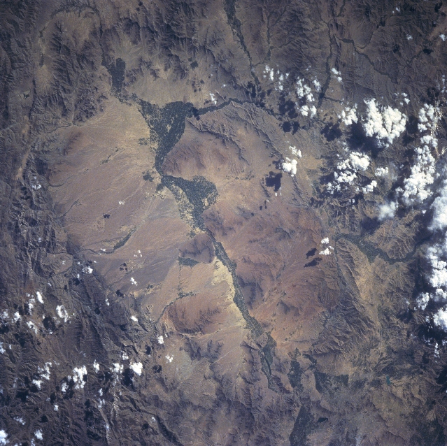 |
| STS091-703-084 Lowgar River Valley, Afghanistan June 1998 The Lowgar River Valley, visible as a dark corridor (aligned northeast-southwest) of varying widths, runs diagonally through the center of the image. The Lowgar River eventually merges with the easterly draining Kabul River just to the east of Kabul, the capital and largest city in Afghanistan. The city of Kabul (partially visible near upper right corner) is difficult to discern because the construction materials used to build the city blends in with the natural landscape. The dark corridor along the banks of the Lowgar River is the result of irrigated agricultural fields. Only 12 percent of the total land area in Afghanistan is considered arable land. Most of the mountain valleys are arid with most precipitation falling on the higher, mountainous elevations in the form of snow. Runoff from the mountains does provide some moisture for agriculture. The average elevation of the valleys around Kabul is 5900 feet (180 meters) above sea level, while many mountains peaks surrounding Kabul exceed 14000 feet (4270 meters). |
| Images: | All Available Images Low-Resolution 384k |
|
| Mission: | STS091 |
|
| Roll - Frame: | 703 - 84 |
|
| Geographical Name: | AFGHANISTAN |
|
| Features: | VALLEY, MAKRAN RA.,KABUL |
|
| Center Lat x Lon: | 34.0N x 69.0E |
|
| Film Exposure: | N | N=Normal exposure, U=Under exposed, O=Over exposed, F=out of Focus |
| Percentage of Cloud Cover-CLDP: | 5 |
|
| Camera:: | HB |
|
| Camera Tilt: | 28 | LO=Low Oblique, HO=High Oblique, NV=Near Vertical |
| Camera Focal Length: | 250 |
|
| Nadir to Photo Center Direction: | W | The direction from the nadir to the center point, N=North, S=South, E=East, W=West |
| Stereo?: | N | Y=Yes there is an adjacent picture of the same area, N=No there isn't |
| Orbit Number: | 72 |
|
| Date: | 19980607 | YYYYMMDD |
| Time: | 104354 | GMT HHMMSS |
| Nadir Lat: | 33.4N |
Latitude of suborbital point of spacecraft |
| Nadir Lon: | 70.6E |
Longitude of suborbital point of spacecraft |
| Sun Azimuth: | 271 | Clockwise angle in degrees from north to the sun measured at the nadir point |
| Space Craft Altitude: | 197 | nautical miles |
| Sun Elevation: | 44 | Angle in degrees between the horizon and the sun, measured at the nadir point |
| Land Views: | VALLEY |
|
| Water Views: | RIVER |
|
| Atmosphere Views: | |
|
| Man Made Views: | |
|
| City Views: | |
|
Photo is not associated with any sequences | ||
| NASA Home Page |
JSC Home Page |
JSC Digital Image Collection |
Earth Science & Remote Sensing |
|
This service is provided by the International Space Station program and the JSC Earth Science & Remote Sensing Unit, ARES Division, Exploration Integration Science Directorate.

|