
Geographic Region: USA-MISSOURI
Feature: ST. LOUIS
|
Geographic Region: USA-MISSOURI Feature: ST. LOUIS |
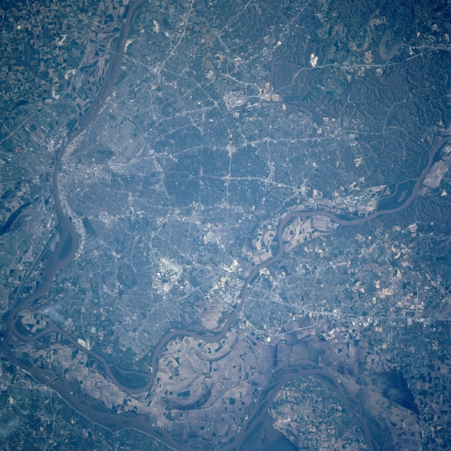 |
| STS090-755-060 St. Louis, Missouri April 1998 The metropolitan area of St. Louis can be seen in this near-vertical-looking view. Bounded to the north by the Missouri River and to the east and southeast by the Mississippi River, St. Louis is the largest city in the state of Missouri. It is a great river-freight handler and a major rail center. St. Louis is the major wholesale, commercial, industrial, financial, medical and cultural center for the eastern Missouri, southwest Illinois region. The metropolitan area of St. Louis is expanding to the west and southwest, and across the Missouri River to the west-northwest. The floodplain area shows almost full recovery from the devastating floods of the spring and summer of 1993. The famous Gateway Arch on the west bank of the Mississippi River symbolizes St. Louis as the 'gateway to the west'. |
| Images: | All Available Images Low-Resolution 389k |
|
| Mission: | STS090 |
|
| Roll - Frame: | 755 - 60 |
|
| Geographical Name: | USA-MISSOURI |
|
| Features: | ST. LOUIS |
|
| Center Lat x Lon: | 38.5N x 90.5W |
|
| Film Exposure: | N | N=Normal exposure, U=Under exposed, O=Over exposed, F=out of Focus |
| Percentage of Cloud Cover-CLDP: | 0 |
|
| Camera:: | HB |
|
| Camera Tilt: | 19 | LO=Low Oblique, HO=High Oblique, NV=Near Vertical |
| Camera Focal Length: | 250 |
|
| Nadir to Photo Center Direction: | SE | The direction from the nadir to the center point, N=North, S=South, E=East, W=West |
| Stereo?: | Y | Y=Yes there is an adjacent picture of the same area, N=No there isn't |
| Orbit Number: | 35 |
|
| Date: | 19980419 | YYYYMMDD |
| Time: | 212736 | GMT HHMMSS |
| Nadir Lat: | 39.1N |
Latitude of suborbital point of spacecraft |
| Nadir Lon: | 91W |
Longitude of suborbital point of spacecraft |
| Sun Azimuth: | 253 | Clockwise angle in degrees from north to the sun measured at the nadir point |
| Space Craft Altitude: | 140 | nautical miles |
| Sun Elevation: | 37 | Angle in degrees between the horizon and the sun, measured at the nadir point |
| Land Views: | FLOOD PLAIN, HILL |
|
| Water Views: | RIVER |
|
| Atmosphere Views: | |
|
| Man Made Views: | URBAN AREA, AIRPORT, HIGHWAY |
|
| City Views: | ST. LOUIS |
|
Photo is not associated with any sequences | ||
| NASA Home Page |
JSC Home Page |
JSC Digital Image Collection |
Earth Science & Remote Sensing |
|
This service is provided by the International Space Station program and the JSC Earth Science & Remote Sensing Unit, ARES Division, Exploration Integration Science Directorate.

|