Geographic Region: BALEARIC ISLANDS
Feature: MALLORCA,PALMA,B. ALCUDIA
|
Geographic Region: BALEARIC ISLANDS Feature: MALLORCA,PALMA,B. ALCUDIA |
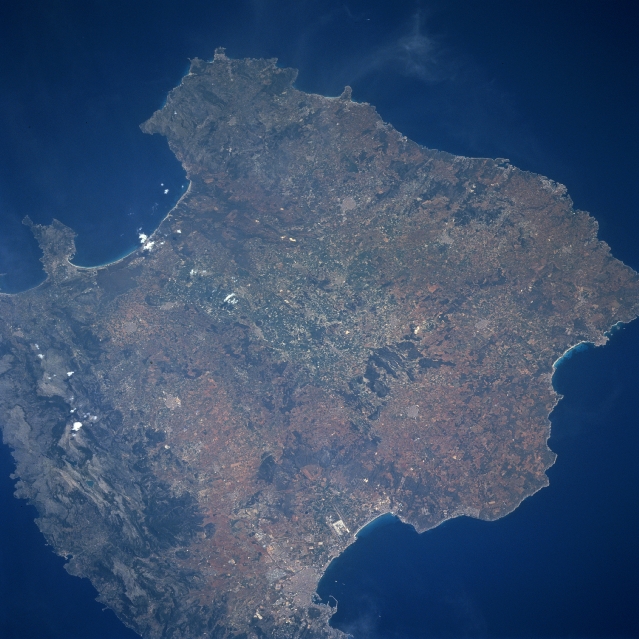 |
| STS090-714-074 Mallorca, Balearic Islands, Spain April 1998 Mallorca, the largest of the Balearic Arcihpelago (1405 square miles-3640 sq. km), which is located in the Mediterranean Sea east of Spain, is a natural bridge between the smaller islands of Menorca (northeast) and Ibiza (southwest). This chain of islands, popular tourist destinations, represent a continuation of the Sierra Nevada mountains of southern Spain which are part of the much larger Alpine system found throughout southern Europe. The Sierra De Tramontana, the most easily recognized mountain range on Mallorca, parallels the entire northwest coast of the island (center of image) and along the east, southwest coast. The rural landscape includes olive and almond trees, as well as strands of pine, fruit, and evergreen oak trees. Approximately half of the islands 650000 people live in he capital city of Polma. Polma is visible in this picture along the northern edge of the Bay of Polma (bottom-center). The two parallel runways (light colored, linear feature) of the busy Polma airport are visible immediately south of the city. |
| Images: | All Available Images Low-Resolution 321k |
|
| Mission: | STS090 |
|
| Roll - Frame: | 714 - 74 |
|
| Geographical Name: | BALEARIC ISLANDS |
|
| Features: | MALLORCA,PALMA,B. ALCUDIA |
|
| Center Lat x Lon: | 39.5N x 3.0E |
|
| Film Exposure: | N | N=Normal exposure, U=Under exposed, O=Over exposed, F=out of Focus |
| Percentage of Cloud Cover-CLDP: | 0 |
|
| Camera:: | HB |
|
| Camera Tilt: | LO | LO=Low Oblique, HO=High Oblique, NV=Near Vertical |
| Camera Focal Length: | 250 |
|
| Nadir to Photo Center Direction: | The direction from the nadir to the center point, N=North, S=South, E=East, W=West |
|
| Stereo?: | Y | Y=Yes there is an adjacent picture of the same area, N=No there isn't |
| Orbit Number: | |
|
| Date: | 1998____ | YYYYMMDD |
| Time: | GMT HHMMSS |
|
| Nadir Lat: | N |
Latitude of suborbital point of spacecraft |
| Nadir Lon: | E |
Longitude of suborbital point of spacecraft |
| Sun Azimuth: | Clockwise angle in degrees from north to the sun measured at the nadir point |
|
| Space Craft Altitude: | nautical miles |
|
| Sun Elevation: | Angle in degrees between the horizon and the sun, measured at the nadir point |
|
| Land Views: | ISLAND, MOUNTAIN |
|
| Water Views: | SEA, BAY |
|
| Atmosphere Views: | |
|
| Man Made Views: | |
|
| City Views: | |
|
Photo is not associated with any sequences | ||
| NASA Home Page |
JSC Home Page |
JSC Digital Image Collection |
Earth Science & Remote Sensing |
|
This service is provided by the International Space Station program and the JSC Earth Science & Remote Sensing Unit, ARES Division, Exploration Integration Science Directorate.

|