Geographic Region: CHILE
Feature: LAKE VILLARRICA
|
Geographic Region: CHILE Feature: LAKE VILLARRICA |
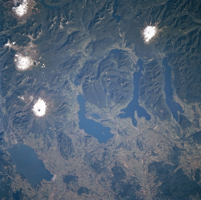 |
| STS089-707-088 Lakes Villarrica, Calafquen, Panguipulli, and Rnihue, Chile January 1998 The Piedmontane Lakes of Villarrica (lower left), Calafquen (near center), Panguipulli (just right of center), and Rinihue (right center) are in central Chile. All of these lakes evolved inside glacial troughs that descended from the Andes. These lakes were built by terminal moraines, behind which melting snow waters were dammed during de-glaciation thousands of years ago. The lakes enjoy a balanced water budget and clean, clear water due to the steady feeding by snowmelt in the high Andes Mountains (top portion of image). The lakes are rich in fish, particularly trout. The region is a renowned tourist attraction. Some snow-covered volcanoes are also visible in the image. Villarrica is a stratovolcano is located just to southeast of Lake Villarrica slightly below the left center of the image. About 20 explosive eruptions have occurred since 1558. The severe eruption in 1971 melted large volumes of snow and ice resulting in mudflows that killed 15 people. The last eruption of the volcano occurred late in 1992. In the upper left corner of the image is Lanin, a dormant stratovolcano, actually located in Argentina. Lanin Volcano, at 12388 feet (3807 meters) has not erupted during historical times. Finally, in the upper right portion of the image is Rinihue, a dormant 7946-foot (2424 meters) stratovolcano that also has not erupted during historical times. |
| Images: | All Available Images Low-Resolution 354k |
|
| Mission: | STS089 |
|
| Roll - Frame: | 707 - 88 |
|
| Geographical Name: | CHILE |
|
| Features: | LAKE VILLARRICA |
|
| Center Lat x Lon: | 39.5S x 72W |
|
| Film Exposure: | N | N=Normal exposure, U=Under exposed, O=Over exposed, F=out of Focus |
| Percentage of Cloud Cover-CLDP: | 0 |
|
| Camera:: | HB |
|
| Camera Tilt: | 4 | LO=Low Oblique, HO=High Oblique, NV=Near Vertical |
| Camera Focal Length: | 100 |
|
| Nadir to Photo Center Direction: | S | The direction from the nadir to the center point, N=North, S=South, E=East, W=West |
| Stereo?: | N | Y=Yes there is an adjacent picture of the same area, N=No there isn't |
| Orbit Number: | 28 |
|
| Date: | 19980124 | YYYYMMDD |
| Time: | 211402 | GMT HHMMSS |
| Nadir Lat: | 39.3S |
Latitude of suborbital point of spacecraft |
| Nadir Lon: | 71.9W |
Longitude of suborbital point of spacecraft |
| Sun Azimuth: | 271 | Clockwise angle in degrees from north to the sun measured at the nadir point |
| Space Craft Altitude: | 208 | nautical miles |
| Sun Elevation: | 32 | Angle in degrees between the horizon and the sun, measured at the nadir point |
| Land Views: | MOUNTAIN, VOLCANO, FOREST, GLACIER |
|
| Water Views: | LAKE |
|
| Atmosphere Views: | |
|
| Man Made Views: | AGRICULTURE |
|
| City Views: | |
|
Photo is not associated with any sequences | ||
| NASA Home Page |
JSC Home Page |
JSC Digital Image Collection |
Earth Science & Remote Sensing |
|
This service is provided by the International Space Station program and the JSC Earth Science & Remote Sensing Unit, ARES Division, Exploration Integration Science Directorate.

|