
Geographic Region: CANADA-Q
Feature: MONTREAL, OTTAWA RIVER
|
Geographic Region: CANADA-Q Feature: MONTREAL, OTTAWA RIVER |
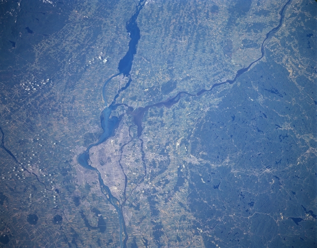 |
| STS085-506-081 Montreal Area, Quebec, Canada August 1997 Montreal is located just east of the confluence of the Ottawa River (the west-to-east dark feature) and the St. Lawrence River. While the small scale of the image precludes the identification of specific urban infrastructure within Montreal, the lighter, built up area can be located on the islands east of the Ottawa-St. Lawrence Rivers junction. The extensive dark-looking area with numerous lakes (very dark irregular shaped features) north of Montreal is forested and glaciated landscape. Similarly, the darker terrain along the southern edge (and south of the St. Lawrence River) of the picture is a glaciated and forested region in upstate New York. Lighter colored, angular land use patterns in the river floodplain are agricultural fields or pastureland. |
| Images: | All Available Images Low-Resolution 299k |
|
| Mission: | STS085 |
|
| Roll - Frame: | 506 - 81 |
|
| Geographical Name: | CANADA-Q |
|
| Features: | MONTREAL, OTTAWA RIVER |
|
| Center Lat x Lon: | 45.5N x 74W |
|
| Film Exposure: | N | N=Normal exposure, U=Under exposed, O=Over exposed, F=out of Focus |
| Percentage of Cloud Cover-CLDP: | 5 |
|
| Camera:: | LH |
|
| Camera Tilt: | 28 | LO=Low Oblique, HO=High Oblique, NV=Near Vertical |
| Camera Focal Length: | 250 |
|
| Nadir to Photo Center Direction: | SW | The direction from the nadir to the center point, N=North, S=South, E=East, W=West |
| Stereo?: | Y | Y=Yes there is an adjacent picture of the same area, N=No there isn't |
| Orbit Number: | 80 |
|
| Date: | 19970812 | YYYYMMDD |
| Time: | 135052 | GMT HHMMSS |
| Nadir Lat: | 46.2N |
Latitude of suborbital point of spacecraft |
| Nadir Lon: | 72.8W |
Longitude of suborbital point of spacecraft |
| Sun Azimuth: | 113 | Clockwise angle in degrees from north to the sun measured at the nadir point |
| Space Craft Altitude: | 155 | nautical miles |
| Sun Elevation: | 40 | Angle in degrees between the horizon and the sun, measured at the nadir point |
| Land Views: | FOREST, ISLAND |
|
| Water Views: | RIVER |
|
| Atmosphere Views: | |
|
| Man Made Views: | |
|
| City Views: | |
|
Photo is not associated with any sequences | ||
| NASA Home Page |
JSC Home Page |
JSC Digital Image Collection |
Earth Science & Remote Sensing |
|
This service is provided by the International Space Station program and the JSC Earth Science & Remote Sensing Unit, ARES Division, Exploration Integration Science Directorate.

|