Geographic Region: THAILAND
Feature: BANGKOK
|
Geographic Region: THAILAND Feature: BANGKOK |
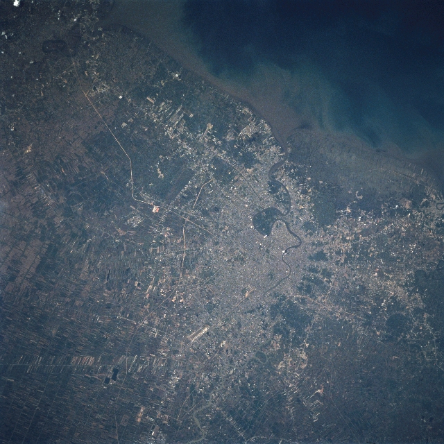 |
| STS084-708-088 Bangkok Area, Thailand May 1997 The Chao Phraya River (dark, thin line) meanders through the metropolitan area (slightly right of center) and empties into the Bight of Bangkok. The population of the metropolitan Bangkok (capital city) is estimated (1998) to be in excess of 10 million people, making it the largest city on mainland Southeast Asia and one of the largest city's in the world. Sediment plumes (brownish-looking water) are visible along the shoreline in the Bay of Bangkok. The Chao Phraya River has created an extensive, flat delta that is used either for agriculture or urban development (lighter areas). The predominant crop is rice but fruits and vegetables are also grown on the vast delta. There is an elaborate system of irrigation ditches and canals that crisscross the rural landscape, furnishing an adequate water supply for Thailand's successful agricultural economy. Thailand is the world's largest producer of rice. Most of the elongated (white-looking), linear features are canals. Some of the less distinct linear features are either highway or railroad right of ways. The broad but short (highly reflective) parallel lines (bottom center) are runways at Don Muang Airport. |
| Images: | All Available Images Low-Resolution 372k |
|
| Mission: | STS084 |
|
| Roll - Frame: | 708 - 88 |
|
| Geographical Name: | THAILAND |
|
| Features: | BANGKOK |
|
| Center Lat x Lon: | 13.5N x 100.5E |
|
| Film Exposure: | N | N=Normal exposure, U=Under exposed, O=Over exposed, F=out of Focus |
| Percentage of Cloud Cover-CLDP: | 0 |
|
| Camera:: | HB |
|
| Camera Tilt: | 15 | LO=Low Oblique, HO=High Oblique, NV=Near Vertical |
| Camera Focal Length: | 250 |
|
| Nadir to Photo Center Direction: | W | The direction from the nadir to the center point, N=North, S=South, E=East, W=West |
| Stereo?: | N | Y=Yes there is an adjacent picture of the same area, N=No there isn't |
| Orbit Number: | 107 |
|
| Date: | 19970522 | YYYYMMDD |
| Time: | 025753 | GMT HHMMSS |
| Nadir Lat: | 13.8N |
Latitude of suborbital point of spacecraft |
| Nadir Lon: | 101.4E |
Longitude of suborbital point of spacecraft |
| Sun Azimuth: | 74 | Clockwise angle in degrees from north to the sun measured at the nadir point |
| Space Craft Altitude: | 208 | nautical miles |
| Sun Elevation: | 58 | Angle in degrees between the horizon and the sun, measured at the nadir point |
| Land Views: | PLAIN |
|
| Water Views: | RIVER, SEDIMENT, DELTA |
|
| Atmosphere Views: | |
|
| Man Made Views: | URBAN AREA, AIRPORT |
|
| City Views: | BANGKOK |
|
Photo is not associated with any sequences | ||
| NASA Home Page |
JSC Home Page |
JSC Digital Image Collection |
Earth Science & Remote Sensing |
|
This service is provided by the International Space Station program and the JSC Earth Science & Remote Sensing Unit, ARES Division, Exploration Integration Science Directorate.

|