 Photo #: STS081-713-86 Date: Jan. 1997
Geographic Region: AUSTRALIA-T
Feature: ENTIRE ISLAND, SMOKE

 Photo #: STS081-713-86 Date: Jan. 1997 Photo #: STS081-713-86 Date: Jan. 1997Geographic Region: AUSTRALIA-T Feature: ENTIRE ISLAND, SMOKE |
 |
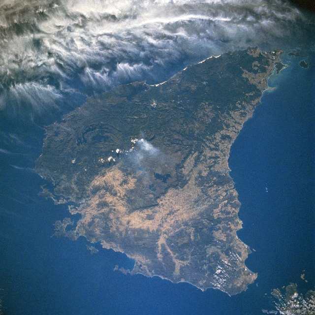
| STS081-713-086 Tasmania, Australia January 1997 Separated from the mainland of Australia by the Bass Strait, the island state of Tasmania lies about 150 miles (240 km) south of Victoria. Tasmania also includes many of the surrounding, offshore islands. Tasmania is Australia's most heavily forested (darker landscape) and least populated state (less than 500000 people). Over 40 percent of the island is protected as World Heritage Sites, National Parks, or private forest reserves. Mountains in the west are covered by rainforest while the central plateau of the state has hundreds of lakes (very dark features). Rainfall amounts generally decrease west to east. Notice in this image that a large area of cloudiness is just off of the west coast. Several large bays are visible around the periphery of the island; including Macquaric Harbor (central west coast), Great Oyster Bay (central east coast), and Storm Bay (along southeast coast). Hobart, the capital of Tasmania, is located at the northwest end of Storm Bay. A smoke plume is visible in the center of the central plateau. |
| Images: | All Available Images Low-Resolution 379k |
|
| Mission: | STS081 |
|
| Roll - Frame: | 713 - 86 |
|
| Geographical Name: | AUSTRALIA-T |
|
| Features: | ENTIRE ISLAND, SMOKE |
|
| Center Lat x Lon: | 42S x 147.0E |
|
| Film Exposure: | N | N=Normal exposure, U=Under exposed, O=Over exposed, F=out of Focus |
| Percentage of Cloud Cover-CLDP: | 20 |
|
| Camera:: | HB |
|
| Camera Tilt: | 14 | LO=Low Oblique, HO=High Oblique, NV=Near Vertical |
| Camera Focal Length: | 40 |
|
| Nadir to Photo Center Direction: | SE | The direction from the nadir to the center point, N=North, S=South, E=East, W=West |
| Stereo?: | N | Y=Yes there is an adjacent picture of the same area, N=No there isn't |
| Orbit Number: | 15 |
|
| Date: | 19970113 | YYYYMMDD |
| Time: | 071828 | GMT HHMMSS |
| Nadir Lat: | 41.4S |
Latitude of suborbital point of spacecraft |
| Nadir Lon: | 146.7E |
Longitude of suborbital point of spacecraft |
| Sun Azimuth: | 263 | Clockwise angle in degrees from north to the sun measured at the nadir point |
| Space Craft Altitude: | 161 | nautical miles |
| Sun Elevation: | 26 | Angle in degrees between the horizon and the sun, measured at the nadir point |
| Land Views: | MOUNTAIN, FOREST |
|
| Water Views: | LAKE, BAY |
|
| Atmosphere Views: | |
|
| Man Made Views: | |
|
| City Views: | |
|
Photo is not associated with any sequences | ||
| NASA Home Page |
JSC Home Page |
JSC Digital Image Collection |
Earth Science & Remote Sensing |
|
|