
Geographic Region: USA-MISSISSIPPI
Feature: CORINTH, WHEELER L.,AGR.
|
Geographic Region: USA-MISSISSIPPI Feature: CORINTH, WHEELER L.,AGR. |
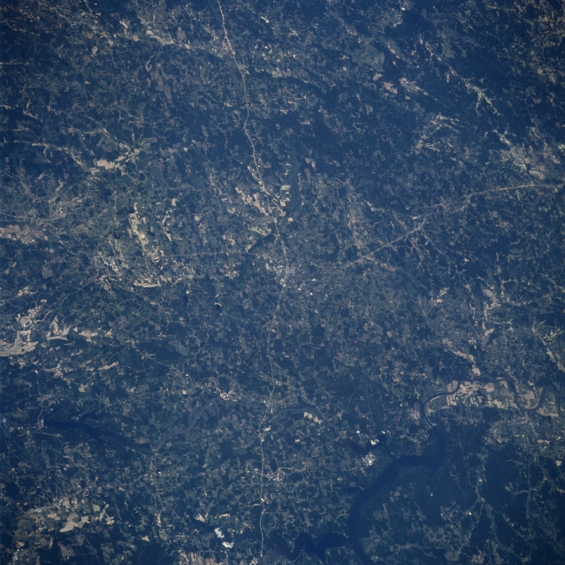 |
| STS078-736-074 Pickwick Lake, Corinth, Mississippi June 1996 The rolling terrain of northeastern Mississippi, with its scattered agricultural fields, can be seen in this west-looking low-oblique view. The small city of Corinth is discernible at the center of the image. Highway 45 traverses north-south through the city, and highway 72 traverses east-west through the city. Corinth is a trade and processing center for lumbering, livestock, and grain industries of the area. During the American Civil War, Corinth was a strategic railroad center. Near the bottom left of the image, Bay Springs Lake is visible. Near the bottom right of the image, the Tennessee River and Pickwick Lake are discernible. |
| Images: | All Available Images Low-Resolution 374k |
|
| Mission: | STS078 |
|
| Roll - Frame: | 736 - 74 |
|
| Geographical Name: | USA-MISSISSIPPI |
|
| Features: | CORINTH, WHEELER L.,AGR. |
|
| Center Lat x Lon: | 35.0N x 88.5W |
|
| Film Exposure: | N | N=Normal exposure, U=Under exposed, O=Over exposed, F=out of Focus |
| Percentage of Cloud Cover-CLDP: | 0 |
|
| Camera:: | HB |
|
| Camera Tilt: | 42 | LO=Low Oblique, HO=High Oblique, NV=Near Vertical |
| Camera Focal Length: | 250 |
|
| Nadir to Photo Center Direction: | NW | The direction from the nadir to the center point, N=North, S=South, E=East, W=West |
| Stereo?: | N | Y=Yes there is an adjacent picture of the same area, N=No there isn't |
| Orbit Number: | 99 |
|
| Date: | 19960626 | YYYYMMDD |
| Time: | 175202 | GMT HHMMSS |
| Nadir Lat: | 33.1N |
Latitude of suborbital point of spacecraft |
| Nadir Lon: | 87.4W |
Longitude of suborbital point of spacecraft |
| Sun Azimuth: | 180 | Clockwise angle in degrees from north to the sun measured at the nadir point |
| Space Craft Altitude: | 145 | nautical miles |
| Sun Elevation: | 80 | Angle in degrees between the horizon and the sun, measured at the nadir point |
| Land Views: | FOREST |
|
| Water Views: | LAKE, RIVER |
|
| Atmosphere Views: | |
|
| Man Made Views: | AGRICULTURE |
|
| City Views: | |
|
Photo is not associated with any sequences | ||
| NASA Home Page |
JSC Home Page |
JSC Digital Image Collection |
Earth Science & Remote Sensing |
|
This service is provided by the International Space Station program and the JSC Earth Science & Remote Sensing Unit, ARES Division, Exploration Integration Science Directorate.

|