Geographic Region: GREECE
Feature: B. OF ALKIONIDHON, MTS.
|
Geographic Region: GREECE Feature: B. OF ALKIONIDHON, MTS. |
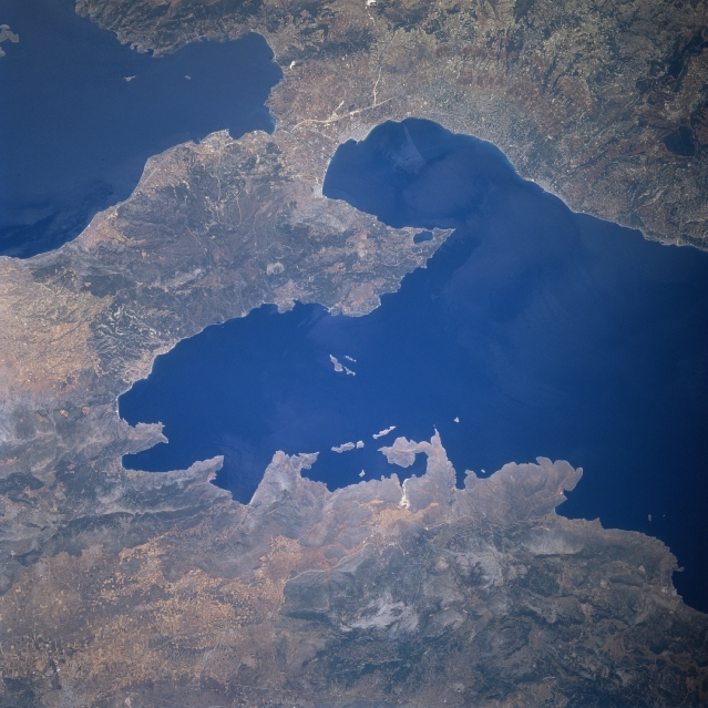 |
| STS078-732-049 Isthmus of Corinth, Greece June 1996 The historical Isthmus of Corinth can be seen in this southwest-looking view. The Isthmus of Corinth is 20 miles (32 km) long and 4 to 8 miles (6 to 13 km) wide, and connects central Greece (bottom left and bottom center of the image) with the Peloponnesus (upper right of the image). The isthmus lies between the Saronic Gulf (upper left) and the Gulf of Corinth (center and right center). The Corinth Canal (not discernible on the image), 4 miles (6 km) long, crosses the isthmus and connects the Adriatic and Aegean Seas. The Gulf of Corinth, an inlet to the Ionian Sea, is 80 miles (130 km) long and from 3 to 20 (5 to 32 km) wide. The gulf separates the Greek mainland from the Peloponnesus. The city of Corinth is located at the southeastern end of the Gulf of Corinth. Corinth is a port and major transportation center trading in olives, tobacco, raisins, and wine. The city was destroyed by an earthquake in 1928 and rebuilt. |
| Images: | All Available Images Low-Resolution 330k |
|
| Mission: | STS078 |
|
| Roll - Frame: | 732 - 49 |
|
| Geographical Name: | GREECE |
|
| Features: | B. OF ALKIONIDHON, MTS. |
|
| Center Lat x Lon: | 38.0N x 23.0E |
|
| Film Exposure: | N | N=Normal exposure, U=Under exposed, O=Over exposed, F=out of Focus |
| Percentage of Cloud Cover-CLDP: | 0 |
|
| Camera:: | HB |
|
| Camera Tilt: | 16 | LO=Low Oblique, HO=High Oblique, NV=Near Vertical |
| Camera Focal Length: | 250 |
|
| Nadir to Photo Center Direction: | NW | The direction from the nadir to the center point, N=North, S=South, E=East, W=West |
| Stereo?: | Y | Y=Yes there is an adjacent picture of the same area, N=No there isn't |
| Orbit Number: | 62 |
|
| Date: | 19960624 | YYYYMMDD |
| Time: | 102637 | GMT HHMMSS |
| Nadir Lat: | 37.7N |
Latitude of suborbital point of spacecraft |
| Nadir Lon: | 23.6E |
Longitude of suborbital point of spacecraft |
| Sun Azimuth: | 179 | Clockwise angle in degrees from north to the sun measured at the nadir point |
| Space Craft Altitude: | 145 | nautical miles |
| Sun Elevation: | 76 | Angle in degrees between the horizon and the sun, measured at the nadir point |
| Land Views: | HILL |
|
| Water Views: | BAY, GULF |
|
| Atmosphere Views: | |
|
| Man Made Views: | AGRICULTURE |
|
| City Views: | |
|
Photo is not associated with any sequences | ||
| NASA Home Page |
JSC Home Page |
JSC Digital Image Collection |
Earth Science & Remote Sensing |
|
This service is provided by the International Space Station program and the JSC Earth Science & Remote Sensing Unit, ARES Division, Exploration Integration Science Directorate.

|