Geographic Region: PERU
Feature: COASTAL PLAIN,ANDES MTS.
|
Geographic Region: PERU Feature: COASTAL PLAIN,ANDES MTS. |
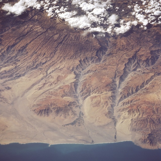 |
| STS077-728-057 Yauca and Acari River Canyons, Peru May 1996 The dry, canyonlike terrain of the Peruvian coast is visible in this northeast-looking, low-oblique photograph. Clouds cover the western Andes Mountains, the longest mountain system in the world, which began to form 600 million years ago. Uplifted coastal plains deeply grooved the coastal areas, sculpturing deep canyons, some of which extend to the coast. A slow uplift continues to build the Andes, which are rising approximately 4 inches (10 centimeters) each century. Visible are many small canyons and two major ones--the Acari River Canyon (center of photograph) and the Yauca River Canyon to its south. Some irrigation is discernible in both river valleys and near the coast where the rivers empty into the Pacific Ocean. Point Chala appears at the bottom right of the photograph. |
| Images: | All Available Images Low-Resolution 130k |
|
| Mission: | STS077 |
|
| Roll - Frame: | 728 - 57 |
|
| Geographical Name: | PERU |
|
| Features: | COASTAL PLAIN,ANDES MTS. |
|
| Center Lat x Lon: | 15S x 74.5W |
|
| Film Exposure: | N | N=Normal exposure, U=Under exposed, O=Over exposed, F=out of Focus |
| Percentage of Cloud Cover-CLDP: | 10 |
|
| Camera:: | HB |
|
| Camera Tilt: | LO | LO=Low Oblique, HO=High Oblique, NV=Near Vertical |
| Camera Focal Length: | 100 |
|
| Nadir to Photo Center Direction: | N | The direction from the nadir to the center point, N=North, S=South, E=East, W=West |
| Stereo?: | N | Y=Yes there is an adjacent picture of the same area, N=No there isn't |
| Orbit Number: | 70 |
|
| Date: | 19960523 | YYYYMMDD |
| Time: | 184950 | GMT HHMMSS |
| Nadir Lat: | 20.4S |
Latitude of suborbital point of spacecraft |
| Nadir Lon: | 72.4W |
Longitude of suborbital point of spacecraft |
| Sun Azimuth: | 322 | Clockwise angle in degrees from north to the sun measured at the nadir point |
| Space Craft Altitude: | 153 | nautical miles |
| Sun Elevation: | 39 | Angle in degrees between the horizon and the sun, measured at the nadir point |
| Land Views: | COAST, MOUNTAIN, FAULT |
|
| Water Views: | |
|
| Atmosphere Views: | |
|
| Man Made Views: | |
|
| City Views: | |
|
Photo is not associated with any sequences | ||
| NASA Home Page |
JSC Home Page |
JSC Digital Image Collection |
Earth Science & Remote Sensing |
|
This service is provided by the International Space Station program and the JSC Earth Science & Remote Sensing Unit, ARES Division, Exploration Integration Science Directorate.

|