Geographic Region: MYANMAR (BURMA)
Feature: MANDALAY,IRRAWADDY RIVER
|
Geographic Region: MYANMAR (BURMA) Feature: MANDALAY,IRRAWADDY RIVER |
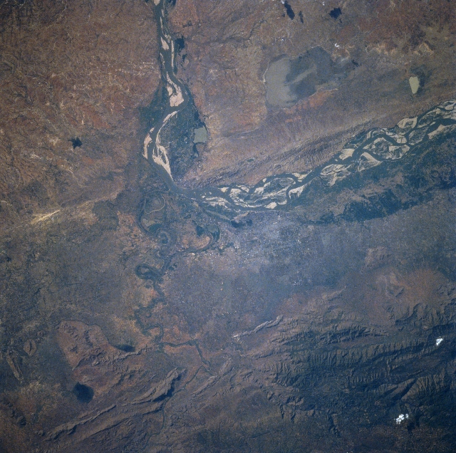 |
| STS075-709-005 Manadalay, Irrawaddy River, Myanmar (Burma) March 1996 The Irrawaddy River, with numerous sandbars and an extremely wide floodplain can be seen in this near-nadir view. The Irrawaddy River is formed by the confluence of the Nmai and Maui Rivers in northern Burma. The river flows generally southward 1300 miles (2100 km) before branching into several mouths that forms an extensive delta that empties into the Andaman Sea. The Irrawaddy provides the main means of communication between cities in the north, like Mandalay, and cities in the south, like Rangoon. Mandalay, a commercial center, a port city, and a railroad terminus is located along the east bank of the river where the river makes a dramatic course change. The only bridge crossing the Irrawaddy connects the city of Mandalay on the east bank of the river with the small city of Sangang on the northwest bank of the river. Mandalay is the center for Burmese Buddhism and is noted for its Arakan Pagoda or temple. The city has a population in excess of 425000. Heavily vegetated green hillsides contrast with the mostly white buildings and pagodas within the city. |
| Images: | All Available Images Low-Resolution 375k |
|
| Mission: | STS075 |
|
| Roll - Frame: | 709 - 5 |
|
| Geographical Name: | MYANMAR (BURMA) |
|
| Features: | MANDALAY,IRRAWADDY RIVER |
|
| Center Lat x Lon: | 22.0N x 96.0E |
|
| Film Exposure: | N | N=Normal exposure, U=Under exposed, O=Over exposed, F=out of Focus |
| Percentage of Cloud Cover-CLDP: | 0 |
|
| Camera:: | HB |
|
| Camera Tilt: | 9 | LO=Low Oblique, HO=High Oblique, NV=Near Vertical |
| Camera Focal Length: | 100 |
|
| Nadir to Photo Center Direction: | E | The direction from the nadir to the center point, N=North, S=South, E=East, W=West |
| Stereo?: | N | Y=Yes there is an adjacent picture of the same area, N=No there isn't |
| Orbit Number: | 73 |
|
| Date: | 19960227 | YYYYMMDD |
| Time: | 085247 | GMT HHMMSS |
| Nadir Lat: | 22.0N |
Latitude of suborbital point of spacecraft |
| Nadir Lon: | 95.6E |
Longitude of suborbital point of spacecraft |
| Sun Azimuth: | 241 | Clockwise angle in degrees from north to the sun measured at the nadir point |
| Space Craft Altitude: | 158 | nautical miles |
| Sun Elevation: | 36 | Angle in degrees between the horizon and the sun, measured at the nadir point |
| Land Views: | PLAIN, MOUNTAIN |
|
| Water Views: | RIVER, LAKE |
|
| Atmosphere Views: | |
|
| Man Made Views: | URBAN AREA |
|
| City Views: | |
|
Photo is not associated with any sequences | ||
| NASA Home Page |
JSC Home Page |
JSC Digital Image Collection |
Earth Science & Remote Sensing |
|
This service is provided by the International Space Station program and the JSC Earth Science & Remote Sensing Unit, ARES Division, Exploration Integration Science Directorate.

|