
Geographic Region: CHINA
Feature: TAKLA MAKAN DESERT,DUNES
|
Geographic Region: CHINA Feature: TAKLA MAKAN DESERT,DUNES |
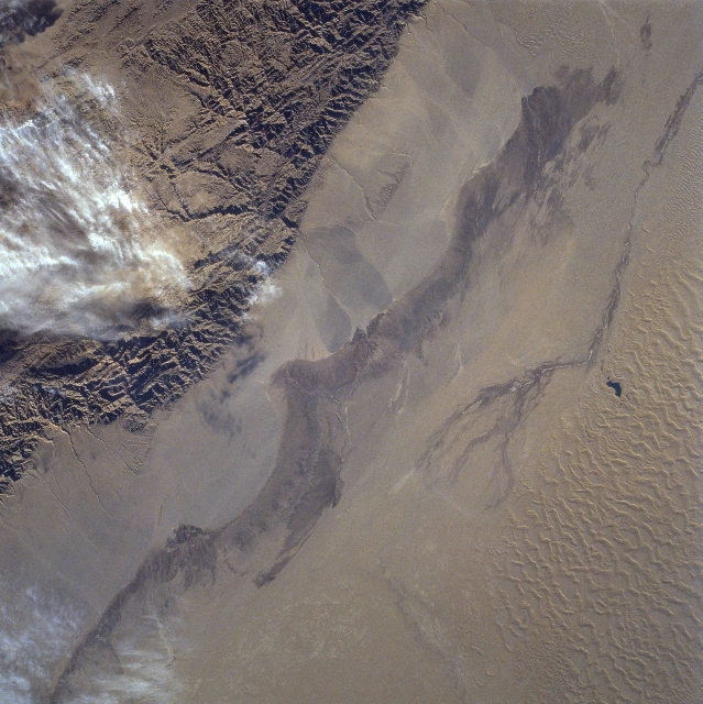 |
| STS074-706-023 Takla Makan Desert, China November 1995 The rugged texture of the Altun Mountains (upper left) that forms part of the northern boundary of the Tibetan Plateau contrasts dramatically with the Takla Makan Desert of western China. Immediately north of the mountains there are large alluvial fans on the north facing slopes, gradually sloping downward in elevation. The elevations from the mountains to the desert floor vary from over 9000 feet (2743 meters) to slightly more than 3000 feet (914 meters) above sea level. The darker swath (diagonal, linear-looking feature) found at the base of the alluvial deposits has more moisture with sparse vegetation. Sand dunes and sand ridges are visible along the northern (lower right) margin of the image. The small dark feature (right center) appears to be a pool of water. The narrow dark swath that parallels the larger swath is a section of the southern route of the Silk Road that was once one of the major corridors linking western China with central Asia. |
| Images: | All Available Images Low-Resolution 363k |
|
| Mission: | STS074 |
|
| Roll - Frame: | 706 - 23 |
|
| Geographical Name: | CHINA |
|
| Features: | TAKLA MAKAN DESERT,DUNES |
|
| Center Lat x Lon: | 39.0N x 88.0E |
|
| Film Exposure: | N | N=Normal exposure, U=Under exposed, O=Over exposed, F=out of Focus |
| Percentage of Cloud Cover-CLDP: | 5 |
|
| Camera:: | HB |
|
| Camera Tilt: | 15 | LO=Low Oblique, HO=High Oblique, NV=Near Vertical |
| Camera Focal Length: | 100 |
|
| Nadir to Photo Center Direction: | SW | The direction from the nadir to the center point, N=North, S=South, E=East, W=West |
| Stereo?: | Y | Y=Yes there is an adjacent picture of the same area, N=No there isn't |
| Orbit Number: | 14 |
|
| Date: | 19951113 | YYYYMMDD |
| Time: | 083802 | GMT HHMMSS |
| Nadir Lat: | 39.7N |
Latitude of suborbital point of spacecraft |
| Nadir Lon: | 88.4E |
Longitude of suborbital point of spacecraft |
| Sun Azimuth: | 223 | Clockwise angle in degrees from north to the sun measured at the nadir point |
| Space Craft Altitude: | 176 | nautical miles |
| Sun Elevation: | 21 | Angle in degrees between the horizon and the sun, measured at the nadir point |
| Land Views: | MOUNTAIN, DESERT, ALLUVIAL FAN |
|
| Water Views: | |
|
| Atmosphere Views: | |
|
| Man Made Views: | |
|
| City Views: | |
|
Photo is not associated with any sequences | ||
| NASA Home Page |
JSC Home Page |
JSC Digital Image Collection |
Earth Science & Remote Sensing |
|
This service is provided by the International Space Station program and the JSC Earth Science & Remote Sensing Unit, ARES Division, Exploration Integration Science Directorate.

|