
Geographic Region: USA-CALIFORNIA
Feature: AGR., MEXICO BORDER,DES.
|
Geographic Region: USA-CALIFORNIA Feature: AGR., MEXICO BORDER,DES. |
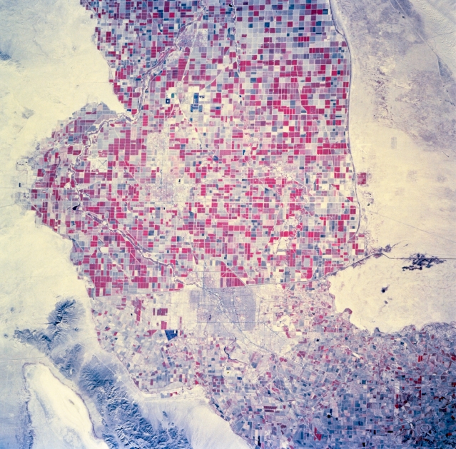 |
| STS073-744-060 Imperial Valley, California, U.S.A., and U.S.-Mexico Border October 1995 This photograph, with vegetation recorded as reds on the color infrared film, features the cultivated, irrigated field patterns at the southern end of the Imperial Valley. The landscapes of the United States and Mexico delineate the differences in agricultural management practices--patterns south of the border become smaller and more irregular. The general outline of Mexicali, surrounded by agricultural field patterns, is discernible immediately south of the border. |
| Images: | All Available Images Low-Resolution 399k |
|
| Mission: | STS073 |
|
| Roll - Frame: | 744 - 60 |
|
| Geographical Name: | USA-CALIFORNIA |
|
| Features: | AGR., MEXICO BORDER,DES. |
|
| Center Lat x Lon: | 33.0N x 115.5W |
|
| Film Exposure: | N | N=Normal exposure, U=Under exposed, O=Over exposed, F=out of Focus |
| Percentage of Cloud Cover-CLDP: | 0 |
|
| Camera:: | HB |
|
| Camera Tilt: | 16 | LO=Low Oblique, HO=High Oblique, NV=Near Vertical |
| Camera Focal Length: | 250 |
|
| Nadir to Photo Center Direction: | NW | The direction from the nadir to the center point, N=North, S=South, E=East, W=West |
| Stereo?: | Y | Y=Yes there is an adjacent picture of the same area, N=No there isn't |
| Orbit Number: | 117 |
|
| Date: | 19951027 | YYYYMMDD |
| Time: | 182031 | GMT HHMMSS |
| Nadir Lat: | 32.5N |
Latitude of suborbital point of spacecraft |
| Nadir Lon: | 115W |
Longitude of suborbital point of spacecraft |
| Sun Azimuth: | 159 | Clockwise angle in degrees from north to the sun measured at the nadir point |
| Space Craft Altitude: | 144 | nautical miles |
| Sun Elevation: | 42 | Angle in degrees between the horizon and the sun, measured at the nadir point |
| Land Views: | VALLEY, DESERT |
|
| Water Views: | |
|
| Atmosphere Views: | |
|
| Man Made Views: | AGRICULTURE |
|
| City Views: | |
|
Photo is not associated with any sequences | ||
| NASA Home Page |
JSC Home Page |
JSC Digital Image Collection |
Earth Science & Remote Sensing |
|
This service is provided by the International Space Station program and the JSC Earth Science & Remote Sensing Unit, ARES Division, Exploration Integration Science Directorate.

|