
Geographic Region: USA-CALIFORNIA
Feature: MOJAVE DESERT, SALT PANS
|
Geographic Region: USA-CALIFORNIA Feature: MOJAVE DESERT, SALT PANS |
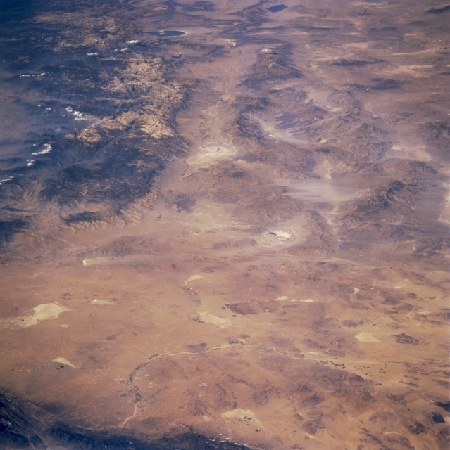 |
| STS073-726-075 Owens River Valley and Central Mojave Desert, California U.S.A. October 1995 This low-oblique, north-looking photograph features the Owens River Valley, the north-central Mojave Desert, Mono Lake, and Walker Lake (Nevada). The fault valley is bordered on the west by the massive Sierra Nevada Mountains and on the east by a series of lower mountain ranges (part of the basin range region). The generally north-south-trending Kern River fault traverses the Sierra Nevada Mountains. Visible are several dry lakes (Owens Lake, the large, white feature in the upper center of the photograph; Searles Lake to the south; Rodgers Dry Lake to the southwest; and Harper Lake to the southeast), isolated low mountains, flat plains, and valleys. The arc of the intermittently flowing Mojave River is apparent near the bottom of the photograph. |
| Images: | All Available Images Low-Resolution 318k |
|
| Mission: | STS073 |
|
| Roll - Frame: | 726 - 75 |
|
| Geographical Name: | USA-CALIFORNIA |
|
| Features: | MOJAVE DESERT, SALT PANS |
|
| Center Lat x Lon: | 35.5N x 117.5W |
|
| Film Exposure: | N | N=Normal exposure, U=Under exposed, O=Over exposed, F=out of Focus |
| Percentage of Cloud Cover-CLDP: | 5 |
|
| Camera:: | HB |
|
| Camera Tilt: | LO | LO=Low Oblique, HO=High Oblique, NV=Near Vertical |
| Camera Focal Length: | 100 |
|
| Nadir to Photo Center Direction: | The direction from the nadir to the center point, N=North, S=South, E=East, W=West |
|
| Stereo?: | N | Y=Yes there is an adjacent picture of the same area, N=No there isn't |
| Orbit Number: | |
|
| Date: | 1995____ | YYYYMMDD |
| Time: | GMT HHMMSS |
|
| Nadir Lat: | N |
Latitude of suborbital point of spacecraft |
| Nadir Lon: | E |
Longitude of suborbital point of spacecraft |
| Sun Azimuth: | Clockwise angle in degrees from north to the sun measured at the nadir point |
|
| Space Craft Altitude: | nautical miles |
|
| Sun Elevation: | Angle in degrees between the horizon and the sun, measured at the nadir point |
|
| Land Views: | MOUNTAIN, RIFT, BASIN, DESERT |
|
| Water Views: | PLAYA |
|
| Atmosphere Views: | |
|
| Man Made Views: | |
|
| City Views: | |
|
Photo is not associated with any sequences | ||
| NASA Home Page |
JSC Home Page |
JSC Digital Image Collection |
Earth Science & Remote Sensing |
|
This service is provided by the International Space Station program and the JSC Earth Science & Remote Sensing Unit, ARES Division, Exploration Integration Science Directorate.

|