
Geographic Region: USA-CALIFORNIA
Feature: SAND DEPOSIT,AGR.,ROADS
|
Geographic Region: USA-CALIFORNIA Feature: SAND DEPOSIT,AGR.,ROADS |
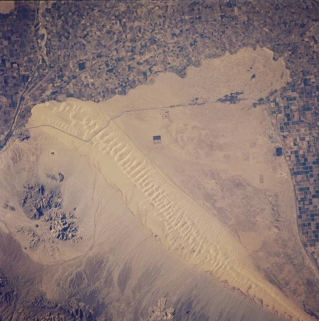 |
| STS073-712-091 Sand Hills, Southern California, U.S.A. October 1995 Almost the entire 35-mile (56-kilometer) length of the northwest-southwest-trending Sand Hills is visible in this near-vertical photograph. The rocky outcrops east of the sand dunes are part of the Chocolate Mountains. The dark, east-west-aligned feature is the All American Canal, which, along with connecting canals, carries water for irrigation into the Imperial Valley of southern California. A small section of the Colorado River and cultivated field patterns in both the United States and Mexico is discernible. |
| Images: | All Available Images Low-Resolution 332k |
|
| Mission: | STS073 |
|
| Roll - Frame: | 712 - 91 |
|
| Geographical Name: | USA-CALIFORNIA |
|
| Features: | SAND DEPOSIT,AGR.,ROADS |
|
| Center Lat x Lon: | 33.0N x 115W |
|
| Film Exposure: | N | N=Normal exposure, U=Under exposed, O=Over exposed, F=out of Focus |
| Percentage of Cloud Cover-CLDP: | 0 |
|
| Camera:: | HB |
|
| Camera Tilt: | 10 | LO=Low Oblique, HO=High Oblique, NV=Near Vertical |
| Camera Focal Length: | 250 |
|
| Nadir to Photo Center Direction: | NW | The direction from the nadir to the center point, N=North, S=South, E=East, W=West |
| Stereo?: | Y | Y=Yes there is an adjacent picture of the same area, N=No there isn't |
| Orbit Number: | 50 |
|
| Date: | 19951023 | YYYYMMDD |
| Time: | 152115 | GMT HHMMSS |
| Nadir Lat: | 32.8N |
Latitude of suborbital point of spacecraft |
| Nadir Lon: | 114.6W |
Longitude of suborbital point of spacecraft |
| Sun Azimuth: | 117 | Clockwise angle in degrees from north to the sun measured at the nadir point |
| Space Craft Altitude: | 145 | nautical miles |
| Sun Elevation: | 18 | Angle in degrees between the horizon and the sun, measured at the nadir point |
| Land Views: | DESERT, DUNE, VALLEY |
|
| Water Views: | |
|
| Atmosphere Views: | |
|
| Man Made Views: | AGRICULTURE |
|
| City Views: | |
|
Photo is not associated with any sequences | ||
| NASA Home Page |
JSC Home Page |
JSC Digital Image Collection |
Earth Science & Remote Sensing |
|
This service is provided by the International Space Station program and the JSC Earth Science & Remote Sensing Unit, ARES Division, Exploration Integration Science Directorate.

|