
Geographic Region: USA-NEW JERSEY
Feature: ATLANTIC CITY, COAST, R.
|
Geographic Region: USA-NEW JERSEY Feature: ATLANTIC CITY, COAST, R. |
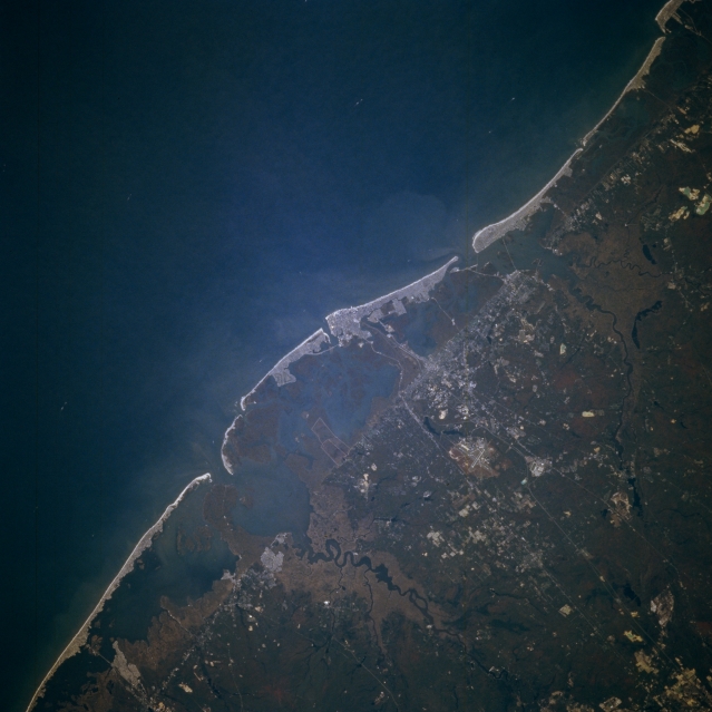 |
| STS073-705-055 Atlantic City Area, New Jersey, U.S.A October 1995 Although the city is not discernible, the famous seaside resort city, Atlantic City, is located in the midst of the light-colored feature in the center of the picture. The location of Atlantic City can be ascertained by noting the several highways (thin, light-colored lines) that converge on the bright area and by looking at the general drainage patterns, including the two most prominent rivers (dark features)-the Mullica River north of Atlantic City and the Great Egg Harbor River south of the city. The extent of the barrier island beach is marked by the almost straight, naturally occurring, northeast-southwest line that extends across the image. A cross section of the landscape from the Atlantic Ocean inland is made up of extensive sandy beaches (light colored); sand dunes; barrier flats; salt marshes; and lagoons. Northwest of the barrier island beaches the land becomes more elevated and forested. |
| Images: | All Available Images Low-Resolution 267k |
|
| Mission: | STS073 |
|
| Roll - Frame: | 705 - 55 |
|
| Geographical Name: | USA-NEW JERSEY |
|
| Features: | ATLANTIC CITY, COAST, R. |
|
| Center Lat x Lon: | 39.5N x 74.5W |
|
| Film Exposure: | N | N=Normal exposure, U=Under exposed, O=Over exposed, F=out of Focus |
| Percentage of Cloud Cover-CLDP: | 0 |
|
| Camera:: | HB |
|
| Camera Tilt: | 20 | LO=Low Oblique, HO=High Oblique, NV=Near Vertical |
| Camera Focal Length: | 250 |
|
| Nadir to Photo Center Direction: | NE | The direction from the nadir to the center point, N=North, S=South, E=East, W=West |
| Stereo?: | Y | Y=Yes there is an adjacent picture of the same area, N=No there isn't |
| Orbit Number: | 82 |
|
| Date: | 19951025 | YYYYMMDD |
| Time: | 135038 | GMT HHMMSS |
| Nadir Lat: | 39.0N |
Latitude of suborbital point of spacecraft |
| Nadir Lon: | 75.2W |
Longitude of suborbital point of spacecraft |
| Sun Azimuth: | 132 | Clockwise angle in degrees from north to the sun measured at the nadir point |
| Space Craft Altitude: | 144 | nautical miles |
| Sun Elevation: | 25 | Angle in degrees between the horizon and the sun, measured at the nadir point |
| Land Views: | ISLAND, COAST, PLAIN |
|
| Water Views: | RIVER, OCEAN, LAGOON |
|
| Atmosphere Views: | |
|
| Man Made Views: | HIGHWAY, AIRPORT |
|
| City Views: | ATLANTIC CITY |
|
Photo is not associated with any sequences | ||
| NASA Home Page |
JSC Home Page |
JSC Digital Image Collection |
Earth Science & Remote Sensing |
|
This service is provided by the International Space Station program and the JSC Earth Science & Remote Sensing Unit, ARES Division, Exploration Integration Science Directorate.

|