Geographic Region: MEXICO
Feature: ALVARA OBRAGON RES.
|
Geographic Region: MEXICO Feature: ALVARA OBRAGON RES. |
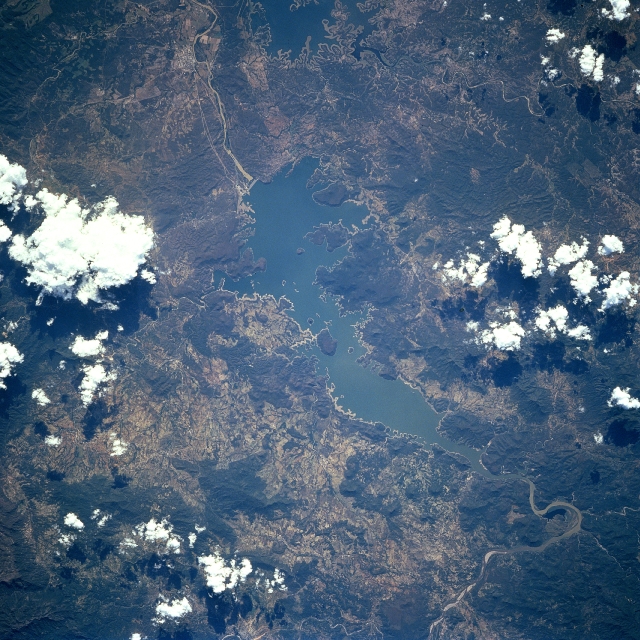 |
| STS068-273-056 Lake Ouiachic, Mexico October 1994 Located in the foothills of the Sierra Madre Occidental, Lake Ouiachic (also referred to as the Lever Obregon Reservoir) can be seen in this south-southwest looking view. Lake Ouiachic is fed by and drained by the Yaqui River. The dam was completed in 1952 with the purpose to regulate water flow of the Yaqui River, prevent floods, and generate electricity. Lake Ouiachic is also an expanding tourist and resort area specializing in fishing, boating, and water skiing. |
| Images: | All Available Images Low-Resolution 398k |
|
| Mission: | STS068 |
|
| Roll - Frame: | 273 - 56 |
|
| Geographical Name: | MEXICO |
|
| Features: | ALVARA OBRAGON RES. |
|
| Center Lat x Lon: | 28.0N x 110W |
|
| Film Exposure: | N | N=Normal exposure, U=Under exposed, O=Over exposed, F=out of Focus |
| Percentage of Cloud Cover-CLDP: | 10 |
|
| Camera:: | HB |
|
| Camera Tilt: | 45 | LO=Low Oblique, HO=High Oblique, NV=Near Vertical |
| Camera Focal Length: | 250 |
|
| Nadir to Photo Center Direction: | NW | The direction from the nadir to the center point, N=North, S=South, E=East, W=West |
| Stereo?: | N | Y=Yes there is an adjacent picture of the same area, N=No there isn't |
| Orbit Number: | 56 |
|
| Date: | 19941003 | YYYYMMDD |
| Time: | 211503 | GMT HHMMSS |
| Nadir Lat: | 26.8N |
Latitude of suborbital point of spacecraft |
| Nadir Lon: | 108.4W |
Longitude of suborbital point of spacecraft |
| Sun Azimuth: | 231 | Clockwise angle in degrees from north to the sun measured at the nadir point |
| Space Craft Altitude: | 118 | nautical miles |
| Sun Elevation: | 46 | Angle in degrees between the horizon and the sun, measured at the nadir point |
| Land Views: | MOUNTAIN |
|
| Water Views: | LAKE, RIVER |
|
| Atmosphere Views: | |
|
| Man Made Views: | DAM |
|
| City Views: | |
|
Photo is not associated with any sequences | ||
| NASA Home Page |
JSC Home Page |
JSC Digital Image Collection |
Earth Science & Remote Sensing |
|
This service is provided by the International Space Station program and the JSC Earth Science & Remote Sensing Unit, ARES Division, Exploration Integration Science Directorate.

|