
Geographic Region: USA-OREGON
Feature: MT. JEFFERSON, MT. HOOD
|
Geographic Region: USA-OREGON Feature: MT. JEFFERSON, MT. HOOD |
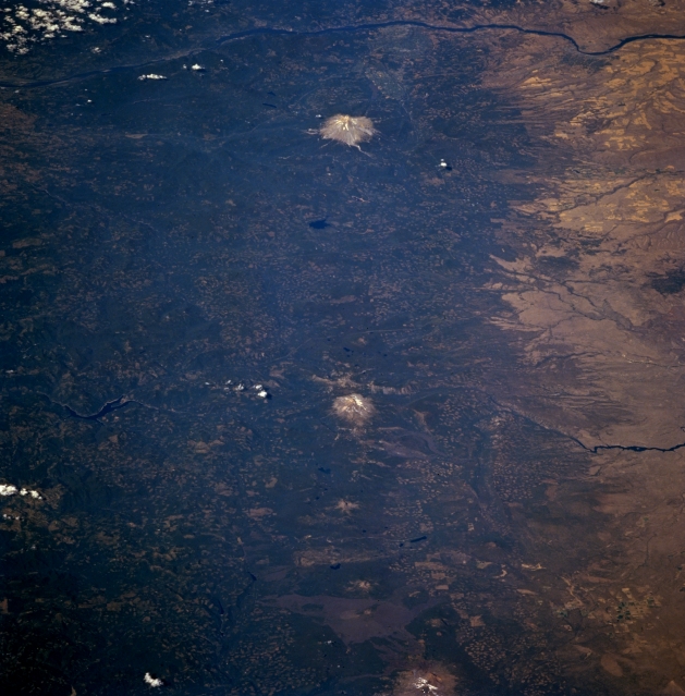 |
| STS068-262-032 Cascade Range, Oregon, U.S.A. October 1994 This spectacular low-oblique, north-looking photograph features the Cascade Range of northern Oregon from North Sister Volcano at the bottom center to Mount Hood at the top center. Along the top portion of the photograph, the Columbia River is visible traversing east to west through the gorge it has cut. The Pacific Ocean shoreline was formed along the western edge of the mountain range, which began forming approximately 65 million years ago as rising magma boiled to the surface and built layer upon layer. Roughly 17 million years ago, the Cascade volcanoes became increasingly active, opening numerous fissures and pouring out lava. Approximately 2 million years later, dozens of the volcanoes erupted simultaneously, building the mountains in the Cascade Range to their present heights. Stratovolcanoes like Mount Hood, Mount Jefferson (the snow-covered peak near the center of the image), and North Sister are visible with less discernible shield volcanoes like Mount Washington and Three Fingered Jack located between North Sister and Mount Jefferson. Lava flows north of North Sister, mostly from Belknap Crater, a new, inactive, shield volcano, encompass areas around McKenzie Pass. Discernible east of Mount Jefferson (center right) are the Metolius River and Lake Chinook and west (left center) are the North Santiam River and Detroit Reservoir. |
| Images: | All Available Images Low-Resolution 322k |
|
| Mission: | STS068 |
|
| Roll - Frame: | 262 - 32 |
|
| Geographical Name: | USA-OREGON |
|
| Features: | MT. JEFFERSON, MT. HOOD |
|
| Center Lat x Lon: | 45.0N x 121.5W |
|
| Film Exposure: | N | N=Normal exposure, U=Under exposed, O=Over exposed, F=out of Focus |
| Percentage of Cloud Cover-CLDP: | 5 |
|
| Camera:: | HB |
|
| Camera Tilt: | LO | LO=Low Oblique, HO=High Oblique, NV=Near Vertical |
| Camera Focal Length: | 250 |
|
| Nadir to Photo Center Direction: | N | The direction from the nadir to the center point, N=North, S=South, E=East, W=West |
| Stereo?: | N | Y=Yes there is an adjacent picture of the same area, N=No there isn't |
| Orbit Number: | 40 |
|
| Date: | 19941002 | YYYYMMDD |
| Time: | 212906 | GMT HHMMSS |
| Nadir Lat: | 41.7N |
Latitude of suborbital point of spacecraft |
| Nadir Lon: | 122.3W |
Longitude of suborbital point of spacecraft |
| Sun Azimuth: | 210 | Clockwise angle in degrees from north to the sun measured at the nadir point |
| Space Craft Altitude: | 117 | nautical miles |
| Sun Elevation: | 40 | Angle in degrees between the horizon and the sun, measured at the nadir point |
| Land Views: | RANGE, VOLCANO, FOREST |
|
| Water Views: | RIVER |
|
| Atmosphere Views: | |
|
| Man Made Views: | |
|
| City Views: | |
|
Photo is not associated with any sequences | ||
| NASA Home Page |
JSC Home Page |
JSC Digital Image Collection |
Earth Science & Remote Sensing |
|
This service is provided by the International Space Station program and the JSC Earth Science & Remote Sensing Unit, ARES Division, Exploration Integration Science Directorate.

|