
Geographic Region: USA-OHIO
Feature: CLEVELAND, LAKE ERIE
|
Geographic Region: USA-OHIO Feature: CLEVELAND, LAKE ERIE |
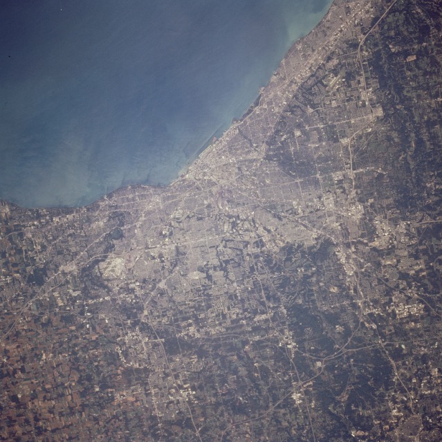 |
| STS068-237-047 Cleveland, Ohio, U.S.A. October 1994 The city of Cleveland, a port of entry and a commercial and industrial center, appears on the southern shore of Lake Erie at the mouth of the Cuyahoga River in this southwest-looking, low-oblique photograph. With a metropolitan population of 2.7 million, the city is a Great Lakes shipping point and one of the nation's leading iron and steel centers. Cleveland is the headquarters for 7 of the approximately 15 shipping lines that own the Great Lakes fleet. The city's industries include metallurgical manufacturing, electrical equipment and chemical production, oil refining, automobile assembly, garment manufacturing, and food processing. Cleveland's central location midway between the coal and oil fields of Pennsylvania and the Minnesota iron mines (via the Great Lakes) spurred the city's industrialization in the 1800s. John D. Rockefeller began his oil dynasty in Cleveland in the late 1870s. West of center in the photograph, the runways of the Cleveland-Hopkins International Airport can be seen. Pollution in the Cuyahoga River and Lake Erie has improved dramatically since the 1960s and early 1970s when flammable products floating on the Cuyahoga River ignited. |
| Images: | All Available Images Low-Resolution 143k |
|
| Mission: | STS068 |
|
| Roll - Frame: | 237 - 47 |
|
| Geographical Name: | USA-OHIO |
|
| Features: | CLEVELAND, LAKE ERIE |
|
| Center Lat x Lon: | 41.5N x 81.5W |
|
| Film Exposure: | N | N=Normal exposure, U=Under exposed, O=Over exposed, F=out of Focus |
| Percentage of Cloud Cover-CLDP: | 0 |
|
| Camera:: | HB |
|
| Camera Tilt: | 23 | LO=Low Oblique, HO=High Oblique, NV=Near Vertical |
| Camera Focal Length: | 250 |
|
| Nadir to Photo Center Direction: | S | The direction from the nadir to the center point, N=North, S=South, E=East, W=West |
| Stereo?: | N | Y=Yes there is an adjacent picture of the same area, N=No there isn't |
| Orbit Number: | 102 |
|
| Date: | 19941006 | YYYYMMDD |
| Time: | 171319 | GMT HHMMSS |
| Nadir Lat: | 42.3N |
Latitude of suborbital point of spacecraft |
| Nadir Lon: | 81.4W |
Longitude of suborbital point of spacecraft |
| Sun Azimuth: | 180 | Clockwise angle in degrees from north to the sun measured at the nadir point |
| Space Craft Altitude: | 116 | nautical miles |
| Sun Elevation: | 43 | Angle in degrees between the horizon and the sun, measured at the nadir point |
| Land Views: | COAST, PLAIN |
|
| Water Views: | RIVER, LAKE |
|
| Atmosphere Views: | |
|
| Man Made Views: | URBAN AREA, AIRPORT, AGRICULTURE |
|
| City Views: | CLEVELAND |
|
Photo is not associated with any sequences | ||
| NASA Home Page |
JSC Home Page |
JSC Digital Image Collection |
Earth Science & Remote Sensing |
|
This service is provided by the International Space Station program and the JSC Earth Science & Remote Sensing Unit, ARES Division, Exploration Integration Science Directorate.

|