
Geographic Region: USA-MONTANA
Feature: FT. PECK LAKE, MISSOURI R
|
Geographic Region: USA-MONTANA Feature: FT. PECK LAKE, MISSOURI R |
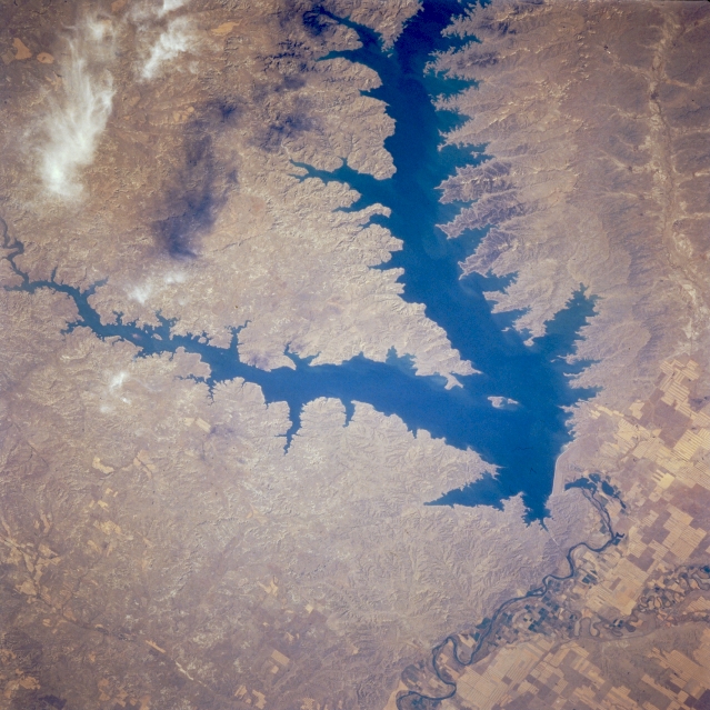 |
| STS068-227-007 Fort Peck Reservoir, Montana, U.S.A. October 1994 Fort Peck Dam, one of the world's largest earth-filled dams, and Fort Peck Reservoir are featured in this west-southwest-looking, low-oblique photograph. Fort Peck Dam was completed in 1940 as one in a series of dams built in the 1930s, 1940s, and 1950s along the upper watershed of the Missouri River. Besides providing flood control, hydroelectric power, irrigation water, and recreation facilities, the dam serves to impound water for later use from spring rains and snowmelt that swell the Missouri River. Fort Peck Reservoir is approximately 135 miles (217 kilometers) long and a maximum of 16 miles (26 kilometers) wide. The broad valley of the Milk River (upper right) served as the course of the Missouri River before ice age glaciers changed the river to its present course further south. The Milk River is shown joining the Missouri River that meanders eastward toward North Dakota. |
| Images: | All Available Images Low-Resolution 347k |
|
| Mission: | STS068 |
|
| Roll - Frame: | 227 - 7 |
|
| Geographical Name: | USA-MONTANA |
|
| Features: | FT. PECK LAKE, MISSOURI R |
|
| Center Lat x Lon: | 48.0N x 106.5W |
|
| Film Exposure: | N | N=Normal exposure, U=Under exposed, O=Over exposed, F=out of Focus |
| Percentage of Cloud Cover-CLDP: | 5 |
|
| Camera:: | HB |
|
| Camera Tilt: | 44 | LO=Low Oblique, HO=High Oblique, NV=Near Vertical |
| Camera Focal Length: | 250 |
|
| Nadir to Photo Center Direction: | E | The direction from the nadir to the center point, N=North, S=South, E=East, W=West |
| Stereo?: | N | Y=Yes there is an adjacent picture of the same area, N=No there isn't |
| Orbit Number: | 23 |
|
| Date: | 19941001 | YYYYMMDD |
| Time: | 201636 | GMT HHMMSS |
| Nadir Lat: | 47.8N |
Latitude of suborbital point of spacecraft |
| Nadir Lon: | 108.4W |
Longitude of suborbital point of spacecraft |
| Sun Azimuth: | 203 | Clockwise angle in degrees from north to the sun measured at the nadir point |
| Space Craft Altitude: | 117 | nautical miles |
| Sun Elevation: | 37 | Angle in degrees between the horizon and the sun, measured at the nadir point |
| Land Views: | |
|
| Water Views: | RESERVOIR, RIVER |
|
| Atmosphere Views: | |
|
| Man Made Views: | DAM, AGRICULTURE |
|
| City Views: | |
|
Photo is not associated with any sequences | ||
| NASA Home Page |
JSC Home Page |
JSC Digital Image Collection |
Earth Science & Remote Sensing |
|
This service is provided by the International Space Station program and the JSC Earth Science & Remote Sensing Unit, ARES Division, Exploration Integration Science Directorate.

|