Geographic Region: MONGOLIA
Feature: ALTAI MTS.,DRAINAGE, R.
|
Geographic Region: MONGOLIA Feature: ALTAI MTS.,DRAINAGE, R. |
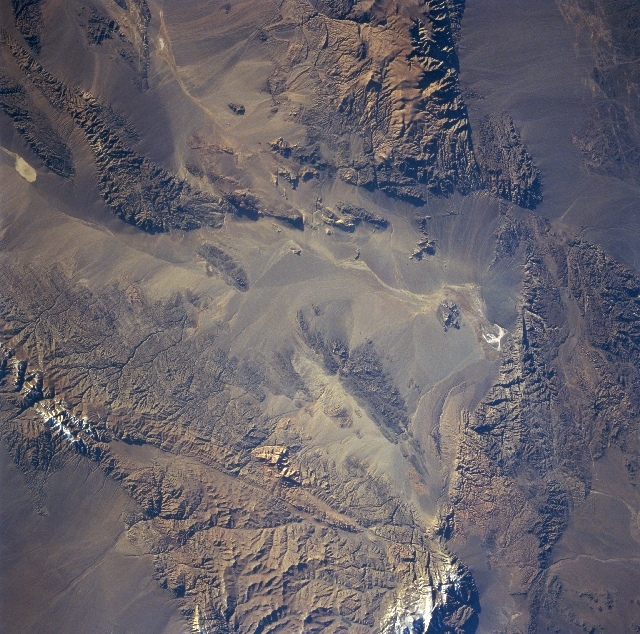 |
| STS068-218-042 Altai Mountains, Mongolia October 1994 The southern ranges of the Altai Mountains are visible in this near-nadir view. A geologically complex mountain system, the Altai extend in a generally southeast direction from south-central Russia to north-central China. Deposits of gold, silver, mercury, iron, lead, zinc, and copper are found throughout the range. The snow-covered 12160 foot (3709 meters) Bus Hayrhan Peak can be seen near the left center of the image. Most of the peaks seen in this view exceed 10000 feet (3050 meters). The basin (center of the view) generally lies at 4000 feet (1220 meters). The whole region of southwest Mongolia is semi-arid to arid. The area in the upper left is part of the Tsagaan Basin where a dry lakebed of the same name is located. The entire region is considered to be part of the vast Gobi Desert. Faults are discernible throughout the scene, but one extending in toward the center basin from just below the right center of the image is clearly visible. |
| Images: | All Available Images Low-Resolution 406k |
|
| Mission: | STS068 |
|
| Roll - Frame: | 218 - 42 |
|
| Geographical Name: | MONGOLIA |
|
| Features: | ALTAI MTS.,DRAINAGE, R. |
|
| Center Lat x Lon: | 45.5N x 94.5E |
|
| Film Exposure: | N | N=Normal exposure, U=Under exposed, O=Over exposed, F=out of Focus |
| Percentage of Cloud Cover-CLDP: | 0 |
|
| Camera:: | HB |
|
| Camera Tilt: | 15 | LO=Low Oblique, HO=High Oblique, NV=Near Vertical |
| Camera Focal Length: | 100 |
|
| Nadir to Photo Center Direction: | W | The direction from the nadir to the center point, N=North, S=South, E=East, W=West |
| Stereo?: | N | Y=Yes there is an adjacent picture of the same area, N=No there isn't |
| Orbit Number: | 10 |
|
| Date: | 19941001 | YYYYMMDD |
| Time: | 004639 | GMT HHMMSS |
| Nadir Lat: | 45.3N |
Latitude of suborbital point of spacecraft |
| Nadir Lon: | 95.0E |
Longitude of suborbital point of spacecraft |
| Sun Azimuth: | 106 | Clockwise angle in degrees from north to the sun measured at the nadir point |
| Space Craft Altitude: | 118 | nautical miles |
| Sun Elevation: | 11 | Angle in degrees between the horizon and the sun, measured at the nadir point |
| Land Views: | MOUNTAIN, FAULT, BASIN, DESERT |
|
| Water Views: | |
|
| Atmosphere Views: | |
|
| Man Made Views: | |
|
| City Views: | |
|
Photo is not associated with any sequences | ||
| NASA Home Page |
JSC Home Page |
JSC Digital Image Collection |
Earth Science & Remote Sensing |
|
This service is provided by the International Space Station program and the JSC Earth Science & Remote Sensing Unit, ARES Division, Exploration Integration Science Directorate.

|