Geographic Region: JAPAN
Feature: E HOKAIDO ISLAND
|
Geographic Region: JAPAN Feature: E HOKAIDO ISLAND |
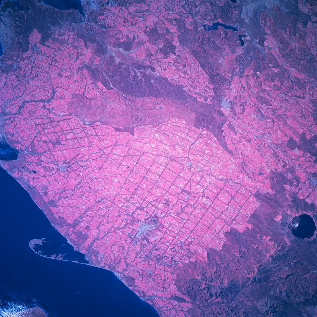 |
| STS068-205-064 Agriculture, Eastern Hokkaido, Japan October 1994 This color infrared image covers almost the same area of eastern Hokkaido as STS68-200-023; however, this image includes large sand spit (lower left) that extends into the Nemuro Strait along the east coast of Hokkaido. A line of northeast to southwest aligned volcanic mountains, including the water-filled caldera, Lake Moshuko (dark, oval feature), and the wooden slopes (deeper reds) are identifiable in the lower right corner of the image. The gridded (dark, intersecting lines) man made pattern that is widespread throughout eastern Hokkaido appears to be an extensive irrigation project to increase agricultural productivity for this region. The lighter colored rural lands highlights the extensive landscape that is being used for the dairy farms and crop production. The darker reds show low-lying, swampy river basins and some hilly topography (near the center of the image). The dark features near the top center are lakes that are part of the Kushiro River drainage basin. A small city is visible along the northern shoreline of Akkeshi Bay (dark feature upper left). |
| Images: | All Available Images Low-Resolution 393k |
|
| Mission: | STS068 |
|
| Roll - Frame: | 205 - 64 |
|
| Geographical Name: | JAPAN |
|
| Features: | E HOKAIDO ISLAND |
|
| Center Lat x Lon: | 43.5N x 145.0E |
|
| Film Exposure: | N | N=Normal exposure, U=Under exposed, O=Over exposed, F=out of Focus |
| Percentage of Cloud Cover-CLDP: | 0 |
|
| Camera:: | HB |
|
| Camera Tilt: | 52 | LO=Low Oblique, HO=High Oblique, NV=Near Vertical |
| Camera Focal Length: | 250 |
|
| Nadir to Photo Center Direction: | NE | The direction from the nadir to the center point, N=North, S=South, E=East, W=West |
| Stereo?: | N | Y=Yes there is an adjacent picture of the same area, N=No there isn't |
| Orbit Number: | 172 |
|
| Date: | 19941011 | YYYYMMDD |
| Time: | 003533 | GMT HHMMSS |
| Nadir Lat: | 42.1N |
Latitude of suborbital point of spacecraft |
| Nadir Lon: | 143.1E |
Longitude of suborbital point of spacecraft |
| Sun Azimuth: | 149 | Clockwise angle in degrees from north to the sun measured at the nadir point |
| Space Craft Altitude: | 111 | nautical miles |
| Sun Elevation: | 36 | Angle in degrees between the horizon and the sun, measured at the nadir point |
| Land Views: | PLAIN, MOUNTAIN, VOLCANO, CALDERA |
|
| Water Views: | LAKE, RIVER, BAY |
|
| Atmosphere Views: | |
|
| Man Made Views: | DEFORESTATION |
|
| City Views: | |
|
Photo is not associated with any sequences | ||
| NASA Home Page |
JSC Home Page |
JSC Digital Image Collection |
Earth Science & Remote Sensing |
|
This service is provided by the International Space Station program and the JSC Earth Science & Remote Sensing Unit, ARES Division, Exploration Integration Science Directorate.

|