
Geographic Region: USA-OKLAHOMA
Feature: BROKEN BOW LAKE
|
Geographic Region: USA-OKLAHOMA Feature: BROKEN BOW LAKE |
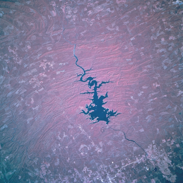 |
| STS068-204-048 Broken Bow Lake, Oklahoma, U.S.A. October 1994 Broken Bow Lake, a recreational area surrounded by forests at the western end of the Ouachita Mountains, is featured in this north-looking, low-oblique, color infrared photograph. The lake is drained by the Mountain Fork River that joins the Little River south of the lake. The McCurtain County Wilderness Area covers the northeastern portion of the lake and expands into the surrounding forested areas. A portion of the small city of Broken Bow is visible south of the lake. |
| Images: | All Available Images Low-Resolution 341k |
|
| Mission: | STS068 |
|
| Roll - Frame: | 204 - 48 |
|
| Geographical Name: | USA-OKLAHOMA |
|
| Features: | BROKEN BOW LAKE |
|
| Center Lat x Lon: | 34.0N x 95W |
|
| Film Exposure: | N | N=Normal exposure, U=Under exposed, O=Over exposed, F=out of Focus |
| Percentage of Cloud Cover-CLDP: | 0 |
|
| Camera:: | HB |
|
| Camera Tilt: | 3 | LO=Low Oblique, HO=High Oblique, NV=Near Vertical |
| Camera Focal Length: | 250 |
|
| Nadir to Photo Center Direction: | N | The direction from the nadir to the center point, N=North, S=South, E=East, W=West |
| Stereo?: | N | Y=Yes there is an adjacent picture of the same area, N=No there isn't |
| Orbit Number: | 151 |
|
| Date: | 19941009 | YYYYMMDD |
| Time: | 173822 | GMT HHMMSS |
| Nadir Lat: | 33.9N |
Latitude of suborbital point of spacecraft |
| Nadir Lon: | 95W |
Longitude of suborbital point of spacecraft |
| Sun Azimuth: | 169 | Clockwise angle in degrees from north to the sun measured at the nadir point |
| Space Craft Altitude: | 111 | nautical miles |
| Sun Elevation: | 49 | Angle in degrees between the horizon and the sun, measured at the nadir point |
| Land Views: | HILL, FOREST |
|
| Water Views: | LAKE |
|
| Atmosphere Views: | |
|
| Man Made Views: | |
|
| City Views: | |
|
Photo is not associated with any sequences | ||
| NASA Home Page |
JSC Home Page |
JSC Digital Image Collection |
Earth Science & Remote Sensing |
|
This service is provided by the International Space Station program and the JSC Earth Science & Remote Sensing Unit, ARES Division, Exploration Integration Science Directorate.

|