
Geographic Region: USA-CALIFORNIA
Feature: LASSEN PEAK, L. ALMANOR
|
Geographic Region: USA-CALIFORNIA Feature: LASSEN PEAK, L. ALMANOR |
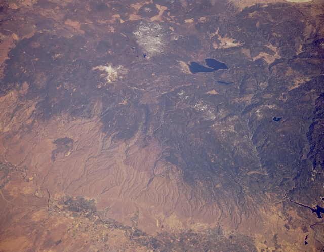 |
| STS068-173-124 Lassen Peak Volcano and Lake Almanor, California, U.S.A. October 1994 This synoptic, low-oblique, northeast-looking photograph captures the timber-covered mountains of the extreme southern Cascades. Snowcapped Lassen Peak, a stratovolcano, is visible north-northwest of dark blue Lake Almanor. Grass- and scrub-covered alluvial fans, with red soil on some of the upper slopes, descend west of the Cascades to the Sacramento Valley. The Sacramento River traverses Red Bluff west of the lake. |
| Images: | All Available Images Low-Resolution 274k |
|
| Mission: | STS068 |
|
| Roll - Frame: | 173 - 124 |
|
| Geographical Name: | USA-CALIFORNIA |
|
| Features: | LASSEN PEAK, L. ALMANOR |
|
| Center Lat x Lon: | 40.5N x 122W |
|
| Film Exposure: | N | N=Normal exposure, U=Under exposed, O=Over exposed, F=out of Focus |
| Percentage of Cloud Cover-CLDP: | 0 |
|
| Camera:: | LH |
|
| Camera Tilt: | 45 | LO=Low Oblique, HO=High Oblique, NV=Near Vertical |
| Camera Focal Length: | 250 |
|
| Nadir to Photo Center Direction: | N | The direction from the nadir to the center point, N=North, S=South, E=East, W=West |
| Stereo?: | Y | Y=Yes there is an adjacent picture of the same area, N=No there isn't |
| Orbit Number: | 120 |
|
| Date: | 19941007 | YYYYMMDD |
| Time: | 195112 | GMT HHMMSS |
| Nadir Lat: | 38.8N |
Latitude of suborbital point of spacecraft |
| Nadir Lon: | 122.7W |
Longitude of suborbital point of spacecraft |
| Sun Azimuth: | 177 | Clockwise angle in degrees from north to the sun measured at the nadir point |
| Space Craft Altitude: | 111 | nautical miles |
| Sun Elevation: | 46 | Angle in degrees between the horizon and the sun, measured at the nadir point |
| Land Views: | VOLCANO, MOUNTAIN, VALLEY |
|
| Water Views: | LAKE |
|
| Atmosphere Views: | |
|
| Man Made Views: | AGRICULTURE |
|
| City Views: | |
|
Photo is not associated with any sequences | ||
| NASA Home Page |
JSC Home Page |
JSC Digital Image Collection |
Earth Science & Remote Sensing |
|
This service is provided by the International Space Station program and the JSC Earth Science & Remote Sensing Unit, ARES Division, Exploration Integration Science Directorate.

|