Geographic Region: MONGOLIA
Feature: L. HOVSGOL, MOUNTAINS
|
Geographic Region: MONGOLIA Feature: L. HOVSGOL, MOUNTAINS |
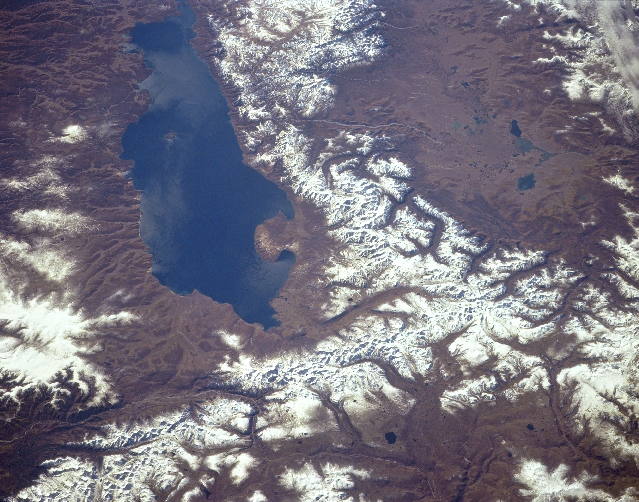 |
| STS068-154-087 Lake Khubsugul, Mongolia October 1994 One of the largest fresh water lakes in Asia, Lake Khubsugul (Hovsgol) can be seen in this south-looking view. Lake Khubsugul is 83 miles (133 km) long and 21 miles (34 km) wide. The Selenga-Moron River drains Lake Khubsugul to the south. The Selenga River, which is one of the main rivers of Mongolia, eventually empties into Lake Baykal to the north. Lake Khubsugul, which is frozen almost six months of the year, supports a major fishing industry. The lake is located in the Eastern Sayan Mountains and the region around the lake suffers from frequent earthquakes. Efforts by the Mongolian Ministry of Environmental Protection has made great progress in keeping the waters of Lake Khubsugul mostly pollution free. The Valley of the Dood Lake is visible to the right (west) of Lake Khubsugul. |
| Images: | All Available Images Low-Resolution 325k |
|
| Mission: | STS068 |
|
| Roll - Frame: | 154 - 87 |
|
| Geographical Name: | MONGOLIA |
|
| Features: | L. HOVSGOL, MOUNTAINS |
|
| Center Lat x Lon: | 51.5N x 100.0E |
|
| Film Exposure: | N | N=Normal exposure, U=Under exposed, O=Over exposed, F=out of Focus |
| Percentage of Cloud Cover-CLDP: | 0 |
|
| Camera:: | LH |
|
| Camera Tilt: | 51 | LO=Low Oblique, HO=High Oblique, NV=Near Vertical |
| Camera Focal Length: | 250 |
|
| Nadir to Photo Center Direction: | SW | The direction from the nadir to the center point, N=North, S=South, E=East, W=West |
| Stereo?: | Y | Y=Yes there is an adjacent picture of the same area, N=No there isn't |
| Orbit Number: | 45 |
|
| Date: | 19941003 | YYYYMMDD |
| Time: | 044817 | GMT HHMMSS |
| Nadir Lat: | 53.2N |
Latitude of suborbital point of spacecraft |
| Nadir Lon: | 101.7E |
Longitude of suborbital point of spacecraft |
| Sun Azimuth: | 176 | Clockwise angle in degrees from north to the sun measured at the nadir point |
| Space Craft Altitude: | 117 | nautical miles |
| Sun Elevation: | 33 | Angle in degrees between the horizon and the sun, measured at the nadir point |
| Land Views: | MOUNTAIN, VALLEY |
|
| Water Views: | LAKE, RIVER |
|
| Atmosphere Views: | |
|
| Man Made Views: | |
|
| City Views: | |
|
Photo is not associated with any sequences | ||
| NASA Home Page |
JSC Home Page |
JSC Digital Image Collection |
Earth Science & Remote Sensing |
|
This service is provided by the International Space Station program and the JSC Earth Science & Remote Sensing Unit, ARES Division, Exploration Integration Science Directorate.

|