Geographic Region: RUSSIAN FEDERATION
Feature: KLYUCHEVSKAYA ERUPTING
|
Geographic Region: RUSSIAN FEDERATION Feature: KLYUCHEVSKAYA ERUPTING |
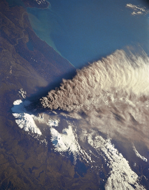 |
| STS068-150-045 Klyuchevskaya Volcano Eruption, Russia October 1994 When this image was obtained, an eruption of Klyuchevskaya Volcano, one of the most active volcanoes on the Kamchatka Peninsula, was underway. Klyuchevskaya Volcano reaches an altitude of 15580 feet (4752 meters) and is the highest mountain in eastern Russia. The volcano is located on the Kamchatka peninsula and is a part of the Pacific "Ring of Fire." The large eruption plume, coming from the summit of the volcano, can be seen spreading ash on the snow-covered regions to the east and southeast. The eruption cloud reached 60000 feet (18300 meters) above sea level, and winds carried ash as far as 640 miles (1030 km) southeast from the volcano into the North Pacific air-routes-impacting up to 70 flights per day. This eruption of Klyuchevskaya was considered to be its largest for the volcano in the past 45 years. Minor eruptions have occurred into the late 1990's from the volcano. |
| Images: | All Available Images Low-Resolution 282k |
|
| Mission: | STS068 |
|
| Roll - Frame: | 150 - 45 |
|
| Geographical Name: | RUSSIAN FEDERATION |
|
| Features: | KLYUCHEVSKAYA ERUPTING |
|
| Center Lat x Lon: | 55.5N x 161.0E |
|
| Film Exposure: | N | N=Normal exposure, U=Under exposed, O=Over exposed, F=out of Focus |
| Percentage of Cloud Cover-CLDP: | 10 |
|
| Camera:: | HB |
|
| Camera Tilt: | LO | LO=Low Oblique, HO=High Oblique, NV=Near Vertical |
| Camera Focal Length: | 250 |
|
| Nadir to Photo Center Direction: | E | The direction from the nadir to the center point, N=North, S=South, E=East, W=West |
| Stereo?: | Y | Y=Yes there is an adjacent picture of the same area, N=No there isn't |
| Orbit Number: | 9 |
|
| Date: | 19940930 | YYYYMMDD |
| Time: | 232441 | GMT HHMMSS |
| Nadir Lat: | 56.9N |
Latitude of suborbital point of spacecraft |
| Nadir Lon: | 157.1E |
Longitude of suborbital point of spacecraft |
| Sun Azimuth: | 147 | Clockwise angle in degrees from north to the sun measured at the nadir point |
| Space Craft Altitude: | 118 | nautical miles |
| Sun Elevation: | 26 | Angle in degrees between the horizon and the sun, measured at the nadir point |
| Land Views: | |
|
| Water Views: | |
|
| Atmosphere Views: | |
|
| Man Made Views: | |
|
| City Views: | |
|
Photo is not associated with any sequences | ||
| NASA Home Page |
JSC Home Page |
JSC Digital Image Collection |
Earth Science & Remote Sensing |
|
This service is provided by the International Space Station program and the JSC Earth Science & Remote Sensing Unit, ARES Division, Exploration Integration Science Directorate.

|