
Geographic Region: USA-OKLAHOMA
Feature: WICHITA FALLS, LAWTON
|
Geographic Region: USA-OKLAHOMA Feature: WICHITA FALLS, LAWTON |
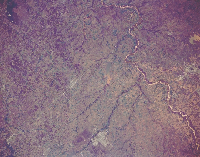 |
| STS066-152-117 Red River Valley; Waurika Lake, Oklahoma November 1994 The plains of southwestern Oklahoma can be seen in this southeast-looking view. The Red river is visible traversing the image from the bottom right (west) to the top center (east). Near the bottom center of the image, the small city of Lawton, Oklahoma and the nearby Wichita Mountains are discernible. Lawton is the commercial center for a surrounding cotton, wheat, and cattle area. The silt-laden waters of Lake Waurika, a recreational lake, can be seen near the center of the image. The Arbuckle Mountains are discernible in the upper left corner of the image. Near the right center of the image, the city of Wichita Falls, Texas can be seen. Wichita Falls has oil refineries and petro-chemical plants. Agriculture and ranching are also important to the city's economy as is Sheppard Air Force Base, which is located to the north of the city. This area is prone to tornadoes during the late winter and early spring of each year. |
| Images: | All Available Images Low-Resolution 305k |
|
| Mission: | STS066 |
|
| Roll - Frame: | 152 - 117 |
|
| Geographical Name: | USA-OKLAHOMA |
|
| Features: | WICHITA FALLS, LAWTON |
|
| Center Lat x Lon: | 34.5N x 98.5W |
|
| Film Exposure: | U | N=Normal exposure, U=Under exposed, O=Over exposed, F=out of Focus |
| Percentage of Cloud Cover-CLDP: | 0 |
|
| Camera:: | LH |
|
| Camera Tilt: | 8 | LO=Low Oblique, HO=High Oblique, NV=Near Vertical |
| Camera Focal Length: | 90 |
|
| Nadir to Photo Center Direction: | SW | The direction from the nadir to the center point, N=North, S=South, E=East, W=West |
| Stereo?: | N | Y=Yes there is an adjacent picture of the same area, N=No there isn't |
| Orbit Number: | 49 |
|
| Date: | 19941106 | YYYYMMDD |
| Time: | 173206 | GMT HHMMSS |
| Nadir Lat: | 34.7N |
Latitude of suborbital point of spacecraft |
| Nadir Lon: | 98.2W |
Longitude of suborbital point of spacecraft |
| Sun Azimuth: | 166 | Clockwise angle in degrees from north to the sun measured at the nadir point |
| Space Craft Altitude: | 162 | nautical miles |
| Sun Elevation: | 38 | Angle in degrees between the horizon and the sun, measured at the nadir point |
| Land Views: | PLAIN |
|
| Water Views: | RIVER |
|
| Atmosphere Views: | |
|
| Man Made Views: | URBAN AREA, AGRICULTURE |
|
| City Views: | |
|
Photo is not associated with any sequences | ||
| NASA Home Page |
JSC Home Page |
JSC Digital Image Collection |
Earth Science & Remote Sensing |
|
This service is provided by the International Space Station program and the JSC Earth Science & Remote Sensing Unit, ARES Division, Exploration Integration Science Directorate.

|