Geographic Region: RUSSIAN FEDERATION
Feature: LAKE BAIKAL
|
Geographic Region: RUSSIAN FEDERATION Feature: LAKE BAIKAL |
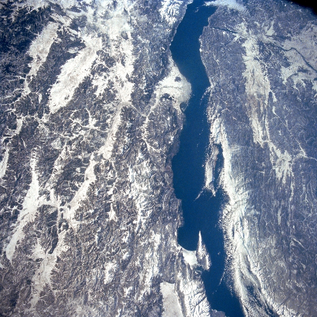 |
| STS066-113-072 Lake Baykal, Russia November 1994 Most of Lake Baykal (elongated, dark feature) is visible in this synoptic southwest view of southeast Siberia. Lake Baykal is a long (400 miles - 650 km), deep (maximum depth 5714 feet - 1742 meters) freshwater lake that covers a fault trench that is generally aligned in a northeast-southwest arc. The lake contains 20 percent of the worlds unfrozen fresh water. Over 365 rivers flow into Lake Baykal and only one river, the Angara River (dark, linear feature near upper right corner of image), flows out of the lake (southwest end of the lake). The lake is so large both in area and depth that it creates its own microclimate within a 15-mile (25 km) radius of the lake. As a result of the moderating effect of the lake winter temperatures are less severe and summer temperatures tend to be slightly cooler. The paralleling, snow-covered valleys on the east (left) side of the lake are a series of rift valleys. The Selenga River Delta (white, roughly triangular-shaped feature) is visible along the eastern shoreline of the lake (slightly above center). Clouds obscure a part of the western coast of Lake Baykal. |
| Images: | All Available Images Low-Resolution 448k |
|
| Mission: | STS066 |
|
| Roll - Frame: | 113 - 72 |
|
| Geographical Name: | RUSSIAN FEDERATION |
|
| Features: | LAKE BAIKAL |
|
| Center Lat x Lon: | 53.0N x 108.0E |
|
| Film Exposure: | N | N=Normal exposure, U=Under exposed, O=Over exposed, F=out of Focus |
| Percentage of Cloud Cover-CLDP: | 0 |
|
| Camera:: | HB |
|
| Camera Tilt: | LO | LO=Low Oblique, HO=High Oblique, NV=Near Vertical |
| Camera Focal Length: | 100 |
|
| Nadir to Photo Center Direction: | W | The direction from the nadir to the center point, N=North, S=South, E=East, W=West |
| Stereo?: | Y | Y=Yes there is an adjacent picture of the same area, N=No there isn't |
| Orbit Number: | 151 |
|
| Date: | 19941113 | YYYYMMDD |
| Time: | 032101 | GMT HHMMSS |
| Nadir Lat: | 44.2N |
Latitude of suborbital point of spacecraft |
| Nadir Lon: | 79.4W |
Longitude of suborbital point of spacecraft |
| Sun Azimuth: | 313 | Clockwise angle in degrees from north to the sun measured at the nadir point |
| Space Craft Altitude: | 695 | nautical miles |
| Sun Elevation: | -56 | Angle in degrees between the horizon and the sun, measured at the nadir point |
| Land Views: | MOUNTAIN |
|
| Water Views: | LAKE |
|
| Atmosphere Views: | |
|
| Man Made Views: | |
|
| City Views: | |
|
Photo is not associated with any sequences | ||
| NASA Home Page |
JSC Home Page |
JSC Digital Image Collection |
Earth Science & Remote Sensing |
|
This service is provided by the International Space Station program and the JSC Earth Science & Remote Sensing Unit, ARES Division, Exploration Integration Science Directorate.

|