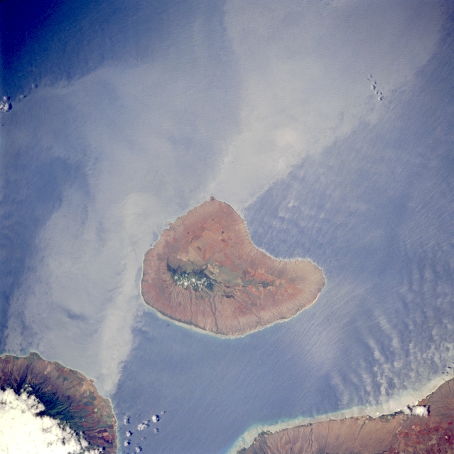
 Photo #: STS065-96-10 Date: Jul. 1994
Geographic Region: USA-HAWAII
Feature: LANAI ISLAND

 Photo #: STS065-96-10 Date: Jul. 1994 Photo #: STS065-96-10 Date: Jul. 1994Geographic Region: USA-HAWAII Feature: LANAI ISLAND |
 |
| STS065-096-010 Lanai, Hawaii, U.S.A. July 1994 Lanai, located west of Maui and south of Molokai, is separated by the Auau and Kalohi Channels, respectively. Volcanic in origin, Lanai's highest elevation [4714 feet (1437 meters)] is near the north-central part of the island. Island wakes trail to the southwest of Lanai and on the leeward side of Maui. Scientists are interested in mapping the turbulent areas on the leeward side of the islands to help document processes by which energy is transported downstream from these and other islands. The extensive use of Lanai for the development of the pineapple industry during the mid-1900s has recently been replaced by resort development. |
| Images: | All Available Images Low-Resolution 278k |
|
| Mission: | STS065 |
|
| Roll - Frame: | 96 - 10 |
|
| Geographical Name: | USA-HAWAII |
|
| Features: | LANAI ISLAND |
|
| Center Lat x Lon: | 20.5N x 157W |
|
| Film Exposure: | N | N=Normal exposure, U=Under exposed, O=Over exposed, F=out of Focus |
| Percentage of Cloud Cover-CLDP: | 10 |
|
| Camera:: | HB |
|
| Camera Tilt: | 18 | LO=Low Oblique, HO=High Oblique, NV=Near Vertical |
| Camera Focal Length: | 250 |
|
| Nadir to Photo Center Direction: | SE | The direction from the nadir to the center point, N=North, S=South, E=East, W=West |
| Stereo?: | Y | Y=Yes there is an adjacent picture of the same area, N=No there isn't |
| Orbit Number: | 84 |
|
| Date: | 19940713 | YYYYMMDD |
| Time: | 215720 | GMT HHMMSS |
| Nadir Lat: | 21.2N |
Latitude of suborbital point of spacecraft |
| Nadir Lon: | 157.5W |
Longitude of suborbital point of spacecraft |
| Sun Azimuth: | 84 | Clockwise angle in degrees from north to the sun measured at the nadir point |
| Space Craft Altitude: | 160 | nautical miles |
| Sun Elevation: | 81 | Angle in degrees between the horizon and the sun, measured at the nadir point |
| Land Views: | ISLAND |
|
| Water Views: | ISLAND WAKE |
|
| Atmosphere Views: | |
|
| Man Made Views: | |
|
| City Views: | |
|
Photo is not associated with any sequences | ||
| NASA Home Page |
JSC Home Page |
JSC Digital Image Collection |
Earth Science & Remote Sensing |
|
|