
Geographic Region: USA-FLORIDA
Feature: JACKSONVILLE
|
Geographic Region: USA-FLORIDA Feature: JACKSONVILLE |
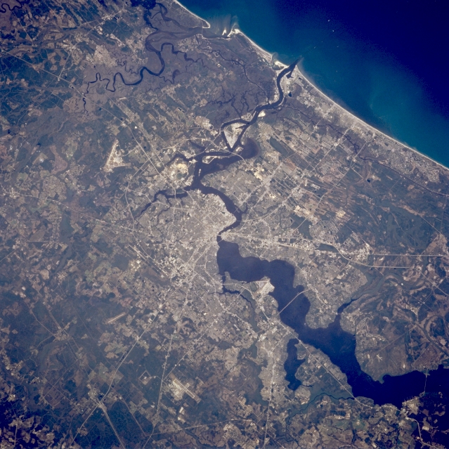 |
| STS062-089-038 Jacksonville, Florida, U.S.A. March 1994 Much of the early history and development of Jacksonville, northeast Florida's largest city, was tied to dark Saint Johns River that cuts through this expanding urban area. South of downtown, before the river narrows and changes direction, the river exceeds 5 miles (8 kilometers) in width. North of the city, meandering Saint Marys River and its broad floodplain form the border between northeast Florida and southeast Georgia before it empties into the Atlantic Ocean. Discernible are several highways (Interstate Highways 95, 295, and 10 and U.S. Highway 1) and three major airports--Jacksonville International Airport north of the city, Cecil Field Naval Air Station southwest of the city, and Jacksonville Naval Air Station south of the city along the west bank of the Saint Johns River. The darker landscape throughout the photograph shows concentrations of natural stands of vegetation, which, in many instances are poorly drained swamplands. |
| Images: | All Available Images Low-Resolution 374k |
|
| Mission: | STS062 |
|
| Roll - Frame: | 89 - 38 |
|
| Geographical Name: | USA-FLORIDA |
|
| Features: | JACKSONVILLE |
|
| Center Lat x Lon: | 30.5N x 81.5W |
|
| Film Exposure: | N | N=Normal exposure, U=Under exposed, O=Over exposed, F=out of Focus |
| Percentage of Cloud Cover-CLDP: | 0 |
|
| Camera:: | HB |
|
| Camera Tilt: | 0 | LO=Low Oblique, HO=High Oblique, NV=Near Vertical |
| Camera Focal Length: | 250 |
|
| Nadir to Photo Center Direction: | The direction from the nadir to the center point, N=North, S=South, E=East, W=West |
|
| Stereo?: | Y | Y=Yes there is an adjacent picture of the same area, N=No there isn't |
| Orbit Number: | 36 |
|
| Date: | 19940306 | YYYYMMDD |
| Time: | 190128 | GMT HHMMSS |
| Nadir Lat: | 30.5N |
Latitude of suborbital point of spacecraft |
| Nadir Lon: | 81.5W |
Longitude of suborbital point of spacecraft |
| Sun Azimuth: | 213 | Clockwise angle in degrees from north to the sun measured at the nadir point |
| Space Craft Altitude: | 162 | nautical miles |
| Sun Elevation: | 49 | Angle in degrees between the horizon and the sun, measured at the nadir point |
| Land Views: | |
|
| Water Views: | RIVER, SWAMP |
|
| Atmosphere Views: | |
|
| Man Made Views: | URBAN AREA, AIRPORT, HIGHWAY |
|
| City Views: | |
|
Photo is not associated with any sequences | ||
| NASA Home Page |
JSC Home Page |
JSC Digital Image Collection |
Earth Science & Remote Sensing |
|
This service is provided by the International Space Station program and the JSC Earth Science & Remote Sensing Unit, ARES Division, Exploration Integration Science Directorate.

|