
Geographic Region: USA-CALIFORNIA
Feature: MARYSVILLE AREA
|
Geographic Region: USA-CALIFORNIA Feature: MARYSVILLE AREA |
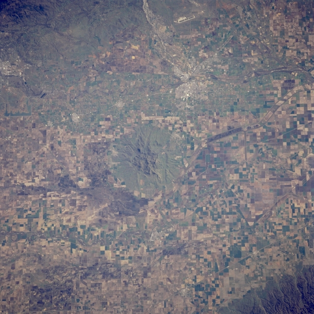 |
| STS062-089-014 Sutter Buttes and Sacramento Valley, California, U.S.A. March 1994 This near-vertical photograph features Sutter Buttes [2132 feet (605 meters)] with the Sacramento River to the west, the Feather River to the east, and Yuba City and Marysville east-southeast at the junction of the Feather and Yuba Rivers. The Yuba River Valley, extending eastward into the foothills of the northern Sierra Nevada Mountains, lies north of the long runways of Beale Air Force Base. Multicolored, rectangular agricultural patterns are visible throughout the Sacramento Valley. |
| Images: | All Available Images Low-Resolution 357k |
|
| Mission: | STS062 |
|
| Roll - Frame: | 89 - 14 |
|
| Geographical Name: | USA-CALIFORNIA |
|
| Features: | MARYSVILLE AREA |
|
| Center Lat x Lon: | 39.0N x 122W |
|
| Film Exposure: | N | N=Normal exposure, U=Under exposed, O=Over exposed, F=out of Focus |
| Percentage of Cloud Cover-CLDP: | 0 |
|
| Camera:: | HB |
|
| Camera Tilt: | 19 | LO=Low Oblique, HO=High Oblique, NV=Near Vertical |
| Camera Focal Length: | 250 |
|
| Nadir to Photo Center Direction: | E | The direction from the nadir to the center point, N=North, S=South, E=East, W=West |
| Stereo?: | Y | Y=Yes there is an adjacent picture of the same area, N=No there isn't |
| Orbit Number: | 36 |
|
| Date: | 19940306 | YYYYMMDD |
| Time: | 185216 | GMT HHMMSS |
| Nadir Lat: | 39.2N |
Latitude of suborbital point of spacecraft |
| Nadir Lon: | 122.9W |
Longitude of suborbital point of spacecraft |
| Sun Azimuth: | 150 | Clockwise angle in degrees from north to the sun measured at the nadir point |
| Space Craft Altitude: | 161 | nautical miles |
| Sun Elevation: | 41 | Angle in degrees between the horizon and the sun, measured at the nadir point |
| Land Views: | VALLEY, HILL |
|
| Water Views: | RIVER, CANAL |
|
| Atmosphere Views: | |
|
| Man Made Views: | AGRICULTURE, AIRPORT |
|
| City Views: | |
|
Photo is not associated with any sequences | ||
| NASA Home Page |
JSC Home Page |
JSC Digital Image Collection |
Earth Science & Remote Sensing |
|
This service is provided by the International Space Station program and the JSC Earth Science & Remote Sensing Unit, ARES Division, Exploration Integration Science Directorate.

|